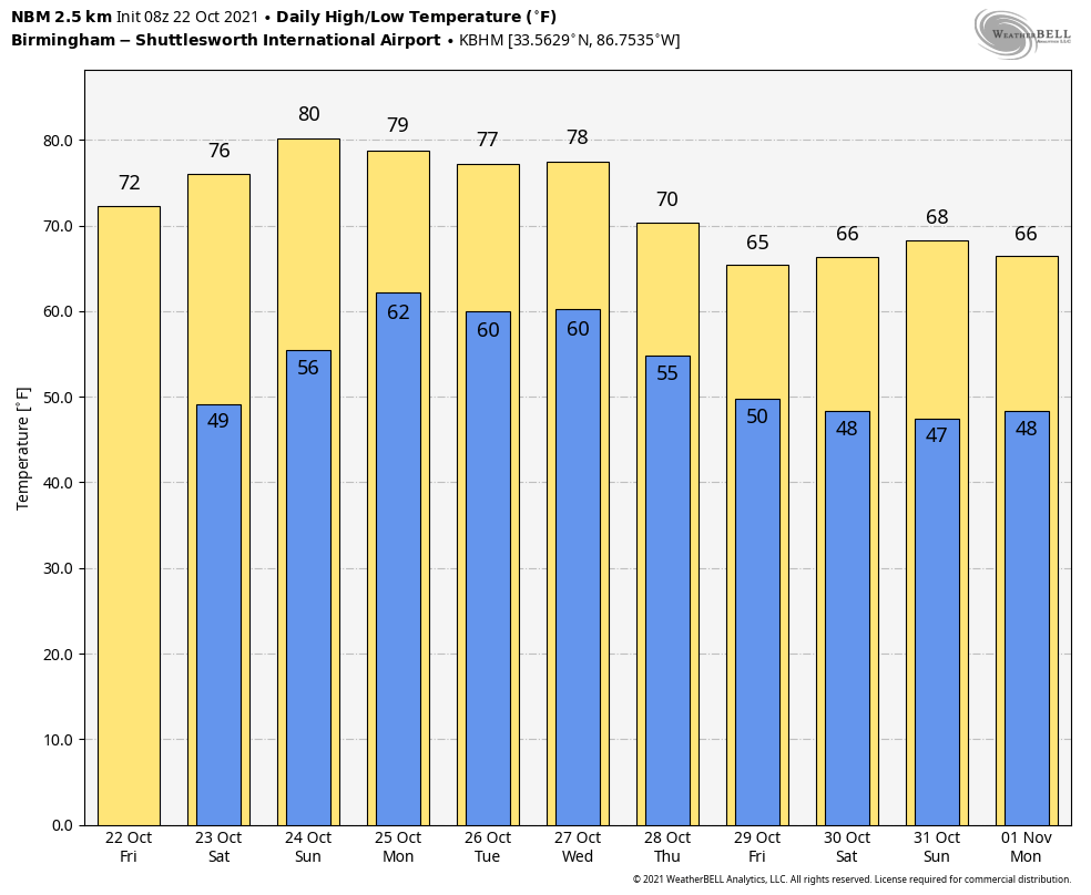
Dry Through Sunday; Active Weather Returns Next Week
RADAR CHECK: A band of showers and storms is over the southeast corner of Alabama early this morning ahead of a cold front; those storms will be out of the state by the time you read this as dry air takes over. We also note there is a dense fog advisory for much of north and central Alabama early this morning; that fog will dissipate by mid-morning as dew points drop. The sky will be sunny today with a high between 72 and 75 degrees; the average high for Birmingham on October 22 is 74.
Tonight will be clear with a low in the mid to upper 40s. And, dry weather will continue through the weekend with lots of sun both days. The high tomorrow will be in the upper 70s, and close to 80 degrees Sunday.
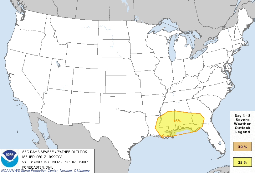
NEXT WEEK: A weather system will bring the chance of a few showers and thunderstorms to Alabama Monday. The main dynamic support will be lifting northward, away from Alabama, and instability will be limited, but a few strong storms are possible. Then, after a mostly dry day Tuesday, a rather robust weather system will impact the Deep South Wednesday. This one will feature good upper air support, strong wind fields, and some instability. SPC has defined a risk of severe thunderstorms for about the southern half of Alabama Wednesday in the their “Day 6” severe weather outlook… but it is too early to discuss specific threats or the timing, but no doubt that could very well be an active weather day for the state.
Then, a surge of cool, dry air rolls into the Deep South Thursday and Friday with highs dropping into the 60s, and lows in the 40s. See the Weather Xtreme video for maps, graphics, and more details.
TROPICS: Tropical storm formation is not expected across the Atlantic basin through next week.
YESTERDAY’S RAIN: The cold front overachieved concerning rain totals across Alabama yesterday. Here are some examples…
Rock Creek 2.23″
Oak Grove 2.17″
Hueytown 2.00″
Bluff Park 1.43″
Crestwood 1.28″
Mountain Brook 1.08″
Remlap 0.84″
FOOTBALL WEATHER: The sky will be clear for high school football games across Alabama tonight with temperatures falling through the 60s.
For the college games tomorrow…
CHATTANOOGA AT SAMFORD (12:00p CT kickoff at Seibert Stadium): Dry and mild with a mostly sunny sky… temperatures will be in the mid to upper 70s.
JACKSONVILLE STATE AT SAM HOUSTON STATE (2:00p CT kickoff in Huntsville, Texas): It will be sunny day; expect a temperature near 77 at kickoff, falling back into the low 70s by the final whistle.
CHARLESTON SOUTHERN AT NORTH ALABAMA (2:00p CT kickoff at Braly Stadium): The sky will be sunny… the kickoff temperature will be close to 75 degrees, falling into the upper 60s by the end of the game.
RICE AT UAB (2:30p CT kickoff at Protective Stadium): The sky will be mostly sunny with a kickoff temperature near 77 degrees, falling into the low 70s by the fourth quarter.
DELTA STATE AT WEST ALABAMA (4:00p CT kickoff at Tiger Stadium): The sky will be mostly clear. About 79 degrees at kickoff, low 70s by the final whistle.
RHODES COLLEGE AT BIRMINGHAM SOUTHERN (4:30p CT kickoff at General Krulak Stadium): The sky will be clear during the game… temperatures will fall from near 77 at kickoff into the 60s by the fourth quarter.
TENNESSEE AT ALABAMA (6:00p kickoff at Bryant-Denny Stadium): We expect a clear sky with temperatures falling from near 74 at kickoff, into the mid 60s by the final whistle.
SOUTH ALABAMA AT LOUISIANA-MONROE (6:00p CT kickoff in Monroe, LA): Expect a clear sky… temperatures will fall from 82 at kickoff, then through the 70s during the game.
ON THIS DATE IN 1997: Game 4 of the World Series between the Cleveland Indians and the Florida Marlins was the coldest game in World Series history. The official game-time temperature was 38 degrees at Jacobs Field in Cleveland. Wind chills as low as 18 degrees was reported during the game.
ON THIS DATE IN 1998: Tropical Depression Thirteen formed on October 22 over the southwestern the Caribbean Sea. By the 24th, this tropical depression became Hurricane Mitch. This hurricane would rapidly intensify over the next two days, reaching Category 5 strength on the 26th. Hurricane Mitch would end up being the second deadliest hurricane in the history of the Atlantic Ocean.
BEACH FORECAST: Click here to see the AlabamaWx Beach Forecast Center page.
WEATHER BRAINS: Don’t forget you can listen to our weekly 90 minute show anytime on your favorite podcast app. This is the show all about weather featuring many familiar voices, including our meteorologists here at ABC 33/40.
CONNECT: You can find me on all of the major social networks…
Look for the next Weather Xtreme video here by 3:00 this afternoon… enjoy the day!
Category: Alabama's Weather, ALL POSTS, Weather Xtreme Videos
About the Author (Author Profile)
James Spann is one of the most recognized and trusted television meteorologists in the industry. He holds the AMS CCM designation and television seals from the AMS and NWA. He is a past winner of the Broadcast Meteorologist of the Year from both professional organizations.Subscribe
If you enjoyed this article, subscribe to receive more just like it.


