Sunny Today; Rain Returns Late Tomorrow Night
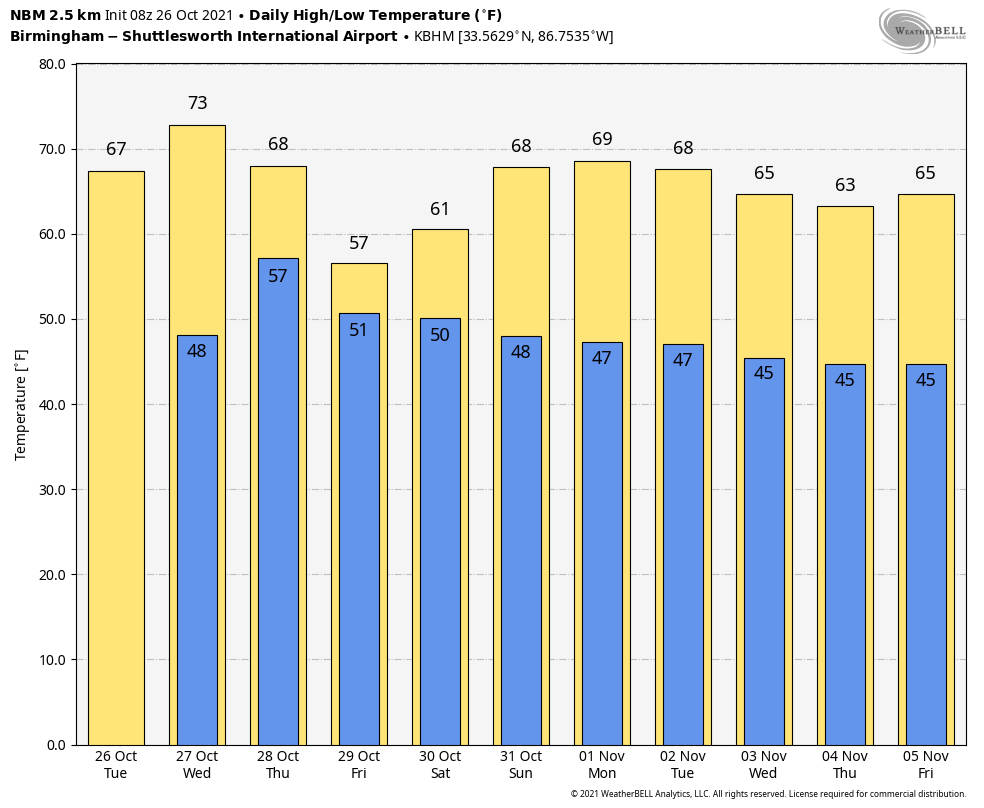
FINE FALL WEATHER: We expect sunshine in full supply across Alabama today with a high in the 67-71 degree range this afternoon. Tonight will be clear and cool… most communities will dip into the 40-45 degree range by daybreak tomorrow. The day tomorrow will be dry, but clouds will increase late in the day… the high tomorrow afternoon will be in the mid 70s.
RAIN RETURNS: A dynamic weather system will bring rain into Alabama late tomorrow night, mostly after midnight. SPC maintains a “slight risk” (level 2/5) of severe thunderstorms for Mobile and Baldwin counties, along with “marginal risk” (level 1/5) as far north as Thomasville, Evergreen, and Brewton.
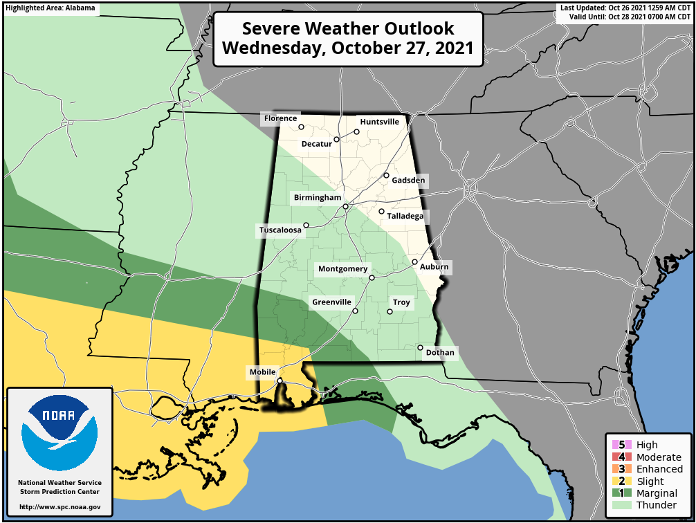
A few storms over Southwest Alabama late tomorrow night could produce strong winds, and an isolated tornado can’t be ruled out. But, for most of Alabama the air will be stable and no severe storms are expected over the northern 2/3 of the state.
Thursday and Friday will be much cooler… temperatures Thursday over North/Central Alabama will hover in the low 60s all day, and on Friday most communities won’t get out of the 50s; it will feel more like winter. The sky will be cloudy both days, and periods of light rain are likely over the northern half of the state thanks to a deep upper low just to the northeast.
THE ALABAMA WEEKEND: Saturday will be a mostly sunny day for the southern counties of the state, but clouds will linger over North Alabama, and some lingering light rain is possible for areas north and east of Birmingham. The high will be in the low 60s over the northern half of the state, and close to 70 over South Alabama. Then, on Sunday, look for sunshine in full supply statewide with a high around 70 degrees.
NEXT WEEK: A cold front has potential to bring a little light rain to the state late Tuesday or Tuesday night, otherwise the week looks cool and dry with highs in the 60s and lows in the 40s. See the Weather Xtreme video for maps, graphics, and more details.
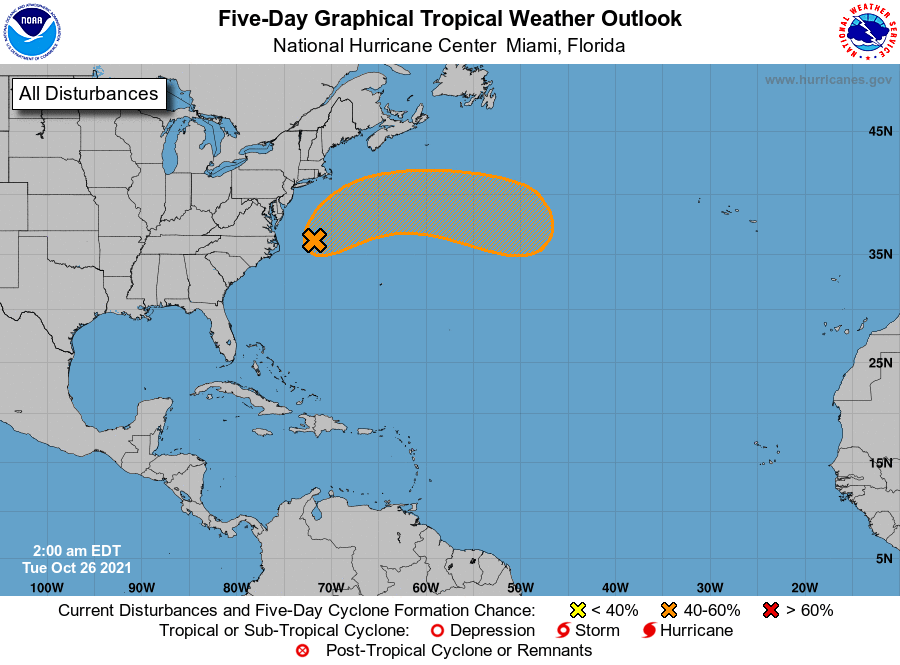
TROPICS: A nor’easter is developing off the upper Atlantic coast; there is some chance it acquires sub-tropical characteristics over the next few days as it moves over the North Atlantic away from the U.S. Otherwise, the Atlantic basin is very quiet.
ON THIS DATE IN 1952: There have been thousands of weather reconnaissance and research flights into hurricanes in the Atlantic and Pacific since the mid-1940s. There have been several close calls, but only four flights have been lost. A B-29 Super-fortress flight into Super Typhoon Wilma 350 miles east of Leyte in the Philippines disappeared on this date. No trace was ever found of the plane or crew. In the last report, the flight was in the Super typhoon’s strongest winds, which were around 160 mph.
ON THIS DATE IN 1998: Hurricane Mitch, the second deadliest hurricane in the Atlantic Ocean, reached Category 5 strength on this day.
BEACH FORECAST: Click here to see the AlabamaWx Beach Forecast Center page.
WEATHER BRAINS: Don’t forget you can listen to our weekly 90 minute show anytime on your favorite podcast app. This is the show all about weather featuring many familiar voices, including our meteorologists here at ABC 33/40.
CONNECT: You can find me on all of the major social networks…
Look for the next Weather Xtreme video here by 3:00 this afternoon… enjoy the day!
Category: Alabama's Weather, ALL POSTS, Weather Xtreme Videos
About the Author (Author Profile)
James Spann is one of the most recognized and trusted television meteorologists in the industry. He holds the AMS CCM designation and television seals from the AMS and NWA. He is a past winner of the Broadcast Meteorologist of the Year from both professional organizations.Subscribe
If you enjoyed this article, subscribe to receive more just like it.


