Rain Moves Out This Evening; Dry, Colder Weekend Ahead
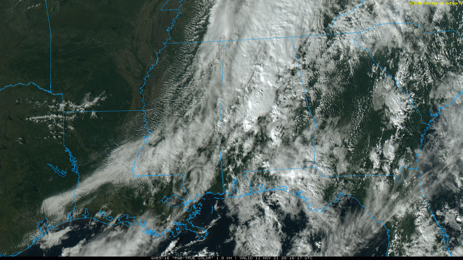
RADAR CHECK: Rain and a few thunderstorms continue to push across Alabama this afternoon ahead of a cold front. The rain is heavy in spots, but the storms are well below severe limits. Rain will end from west to east over the next few hours as the front moves eastward and dry air returns.
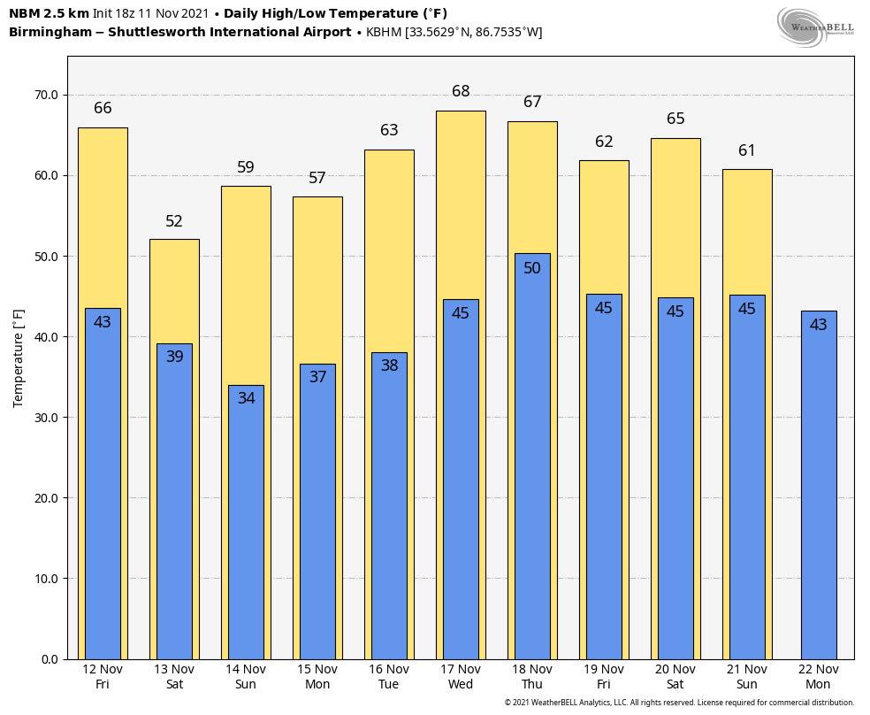
TOMORROW THROUGH THE WEEKEND: Tomorrow will be a sunny day with a high in the 60s… then a secondary push of colder air rolls in tomorrow night. Sunny weather continues over the weekend, but the high Saturday will drop into the 50-55 degree range, followed by mid to upper 50s Sunday. Lows will be in the 30s, and many spots will see a freeze early Sunday morning. Colder spots will drop into the 20s.
NEXT WEEK: Dry weather continues during the first half of the week with sunny days and fair nights; the high Monday will be in the upper 50s, followed by 60s Tuesday and Wednesday. A cold front will bring showers back to the state late Thursday and Thursday night… See the Weather Xtreme video for maps, graphics, and more details.
TROPICS: A large and powerful non-tropical area of low pressure located several hundred miles southeast of Cape Race Newfoundland is producing a broad area of showers, gale to near-hurricane-force winds, and dangerous seas across portions of the north-central Atlantic. Although the chance for subtropical development continues to decrease as it moves over much cooler waters, this system is forecast to intensify into a hurricane-force extratropical low by tonight. It won’t get a name since it is a cold core system.
The rest of the Atlantic basin is very quiet.
FOOTBALL WEATHER: For the high school playoff games Friday night, the sky will be clear with temperatures mostly in the 40s.
For the college games Saturday…
NEW MEXICO STATE AT ALABAMA (11:00a CT kickoff at Bryant-Denny Stadium): Expect a sunny sky with temperatures rising from near 48 at kickoff, into the mid 50s by the second half.
MISSISSIPPI STATE AT AUBURN (11:00a CT kickoff at Jordan-hare Stadium): With a sunny sky, temperatures will rise from 50 degrees at kickoff, to near 56 by the final whistle.
SAMFORD AT FLORIDA (11a CT kickoff at Gainesville, FL): The sky will be partly sunny, and a brief shower is possible during the game, especially during the second half. Temperatures will be in the low 70s.
MISSISSIPPI COLLEGE AT WEST ALABAMA (1:00p CT kickoff at Tiger Stadium): The sky will be sunny with temperatures in the 50s during the game.
BIRMINGHAM SOUTHERN AT MILLSAPS COLLEGE (1:00p CT kickoff at Jackson, MS): A sunny day for the game with temperatures in the 50s.
SOUTH ALABAMA AT APPALACHIAN STATE (1:30p CT kickoff at Boone, NC): Cold and dry weather. Despite a sunny sky, temperatures will be only in the low to mid 40s.
KENNESAW STATE AT NORTH ALABAMA (2:00p CT kickoff at Tom Braly Stadium): With a clear sky temperatures will drop from near 52 at kickoff into the 40s by the fourth quarter.
UAB AT MARSHALL (2:30p CT kickoff at Huntington, WV): The weather will be dry and cold… a clear sky with temperatures in the 40s.
LOUISIANA AT TROY (2:30p CT kickoff at Veterans Memorial Stadium): The day will be cool and dry; with a clear sky temperatures will fall from 58 degrees at kickoff to near 50 by the fourth quarter.
JACKSONVILLE STATE AT LAMAR (4:00p CT kickoff at Beaumont, TX): The sky will be clear with temperatures falling from near 65 at kickoff into the 50s by the second half.
ON THIS DATE IN 1911: A powerful cold front, known as the Great Blue Norther of 1911, produced some of the most extreme temperature changes to the nation’s midsection. In association with this front some cities set both a record high and a record low in the same day. Temperature plunges that have never been recorded before or since shocked the people who were in the cold blast’s path.
Ahead of the cold front, a warm and moist environment caused a severe weather outbreak with several strong tornadoes reported in Iowa, Illinois, Indiana, Wisconsin, and Michigan. An estimated F4 tornado occurred from Janesville to Milton, Wisconsin, and caused extensive damage to several farms and killed nine people. The citizens of Janesville, Wisconsin, reported blizzard conditions with a temperature near zero within an hour of the tornado.
ON THIS DATE IN 1940: An Armistice Day storm raged across the Great Lakes Region and the Upper Midwest. A blizzard left 49 dead in Minnesota, and gales on Lake Michigan caused shipwrecks resulting in 59 deaths. Up to seventeen inches of snow fell in Iowa, and at Duluth MN, the barometric pressure reached 28.66 inches. The blizzard claimed a total of 154 lives and killed thousands of cattle in Iowa. Huge snowdrifts isolated whole towns.
BEACH FORECAST: Click here to see the AlabamaWx Beach Forecast Center page.
WEATHER BRAINS: Don’t forget you can listen to our weekly 90 minute show anytime on your favorite podcast app. This is the show all about weather featuring many familiar voices, including our meteorologists here at ABC 33/40.
CONNECT: You can find me on all of the major social networks…
Look for the next Weather Xtreme video here by 6:00 a.m. tomorrow…
Category: Alabama's Weather, ALL POSTS, Weather Xtreme Videos
About the Author (Author Profile)
James Spann is one of the most recognized and trusted television meteorologists in the industry. He holds the AMS CCM designation and television seals from the AMS and NWA. He is a past winner of the Broadcast Meteorologist of the Year from both professional organizations.Subscribe
If you enjoyed this article, subscribe to receive more just like it.


