Warming Trend Continues; A Few Showers Thursday
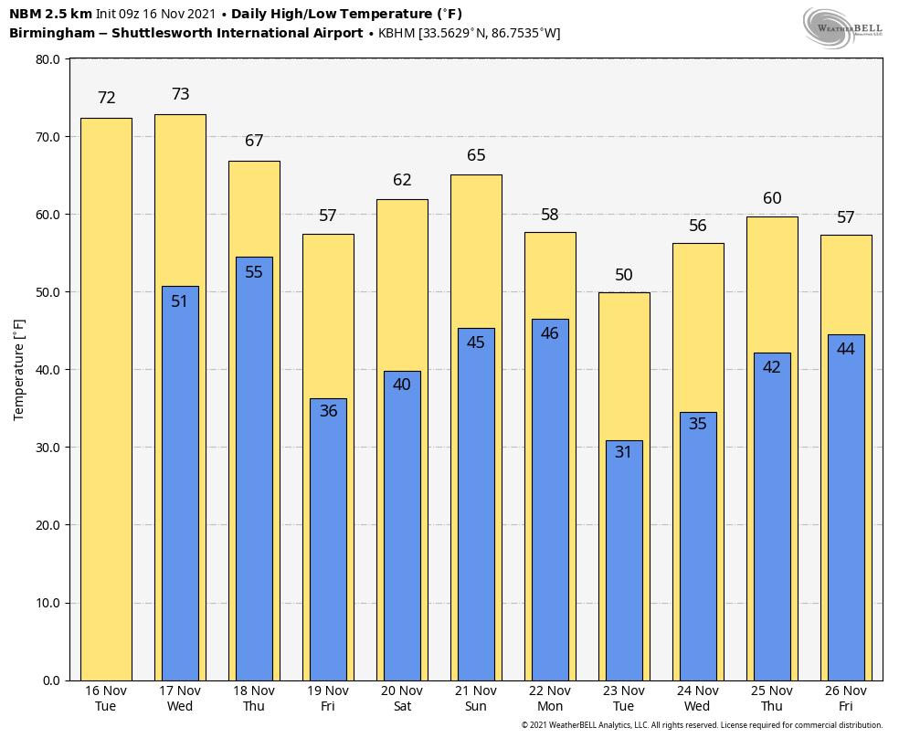
MILD AFTERNOONS: Dry weather continues across Alabama through tomorrow with partly to mostly sunny days. The warming trend continues; afternoon highs will be in the 70-75 degree range for most places, about 5 to 10 degrees above average.
Clouds return to the state Thursday as a cold front approaches, and a few scattered light rain showers are possible over the northern half of the state by afternoon. Moisture will be very limited, and rain amounts should be under a quarter of an inch for most communities. Thursday’s high will be in the mid to upper 60s.
FRIDAY AND THE WEEKEND: Cooler air returns to the state Friday… despite sunshine in full force temperatures won’t get out of the 50s. Then, Saturday promises to be a beautiful fall day; after a morning low between 36 and 44 we project a high in the mid 60s. The weather stay dry Sunday… the sky will be partly sunny with a high in the upper 60s. Clouds will increase Sunday night.
THANKSGIVING WEEK: A cold front will push a band of showers into the state Monday. Again, moisture will be limited, and rain amounts should be fairly light (under 1/4 inch for most places). Tuesday and Wednesday will be dry with cold mornings; looks like temperatures will be in the 25-32 degree range early Tuesday, followed by a high around 50. Then, we reach the mid to upper 50s Wednesday with a good supply of sunshine.
The latest model trends look dry and cool for Thanksgiving Day; some rain is possible by Friday (November 26). See the Weather Xtreme video for maps, graphics, and more details.
RAIN UPDATE: Here are rain totals since January 1, and the departure from average…
Mobile 77.58″ (+18.20″)
Birmingham 64.01″ (+14.45″)
Tuscaloosa 62.55″ (+16.45″)
Huntsville 58.30″ (+12.26″)
Muscle Shoals 56.74″ (+10.37″)
Dothan 56.69″ (+9.79″)
Montgomery 50.96″ (+6.84″)
Anniston 43.13″ (-2.08″)
ON THIS DATE IN 1989: Snow squalls moved across North Alabama with temperatures in the low 30s, making for challenging conditions for tornado recovery efforts in Huntsville. The day before an F4 tornado tore through the southern part of the city, killing 21 people and injuring almost 500.
ON THIS DATE IN 2006: An early morning F3 tornado killed eight people, injured 20 others and left 100 people homeless in Riegelwood, North Carolina. This storm was the second deadliest tornado in the state in the past 50 years.
ON THIS DATE IN 2011: An EF-1 tornado touched down in northeast Macon County near Notasulga… it continued northeastward into Lee County and caused extensive tree damage which resulted in damage to dozens of homes and mobile homes on the western side of Auburn. Several residences were totally destroyed. The tornado crossed the southern edge of Auburn University’s Campus and caused damage to homes and the baseball facilities at Auburn High School. The tornado moved across Lake Harding and into Georgia. The tornado moved across Harris County Georgia for another 26 miles and strengthened to an EF2. The total tornado path length was 59 miles long.
BEACH FORECAST: Click here to see the AlabamaWx Beach Forecast Center page.
WEATHER BRAINS: Don’t forget you can listen to our weekly 90 minute show anytime on your favorite podcast app. This is the show all about weather featuring many familiar voices, including our meteorologists here at ABC 33/40.
CONNECT: You can find me on all of the major social networks…
Look for the next Weather Xtreme video here by 3:00 this afternoon… enjoy the day!
Category: Alabama's Weather, ALL POSTS, Weather Xtreme Videos
About the Author (Author Profile)
James Spann is one of the most recognized and trusted television meteorologists in the industry. He holds the AMS CCM designation and television seals from the AMS and NWA. He is a past winner of the Broadcast Meteorologist of the Year from both professional organizations.Subscribe
If you enjoyed this article, subscribe to receive more just like it.


