Warmer Days Ahead; No Rain Anytime Soon
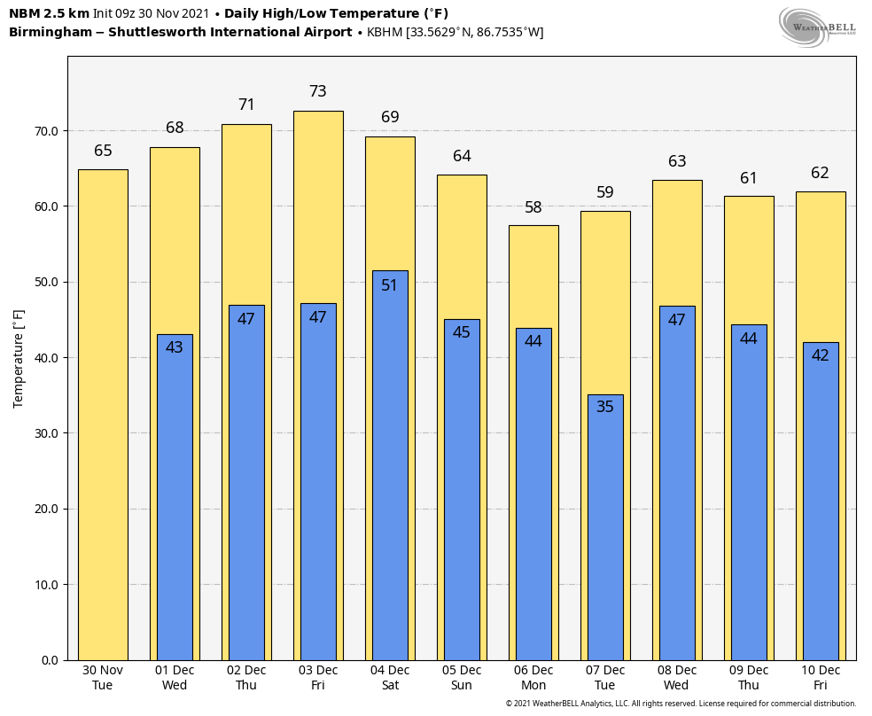
NICE WARM-UP TODAY: Temperatures are in the 25-35 degree range across Alabama early this morning, but despite the morning chill we project a nice warm-up today. With sunshine in full supply, we project a high in the mid 60s for most places this afternoon. The average high for Birmingham on November 30 is 61.
For the rest of the week, look for sunny days, clear nights, and a warming trend. Temperatures reach the upper 60s tomorrow, followed by low 70s Thursday and Friday.
THE ALABAMA WEEKEND: New global model data suggests the weather weather will continue into the weekend. Look for a partly sunny sky Saturday and Sunday with afternoon highs remaining about ten degrees above average for early December, in the 70-73 degree range. Clouds will increase late Sunday, and a cold front will bring rain to the state late Sunday night and early Monday morning. Moisture will be limited, and rain amounts should be 1/4 inch or less for most communities.
NEXT WEEK: After the rain ends early Monday, look for a clearing sky and cooler temperatures; the high Monday will be in the mid to upper 50s. Tuesday will be dry with a high in the 60s, then a disturbance will bring a chance of rain Wednesday. Rain at times will remain possible Thursday and Friday as an unsettled pattern develops… See the Weather Xtreme video for maps, graphics, and more details.
HURRICANE SEASON ENDS: Today marks the last day of the 2021 hurricane season. There were a total of 21 named storms, although a number of them were weak, short lived systems far from land. There were seven hurricanes, four of them reaching “major” status. Of those, only one U.S. hurricane landfall involved a major storm: Hurricane Ida, which slammed into Port Fourchon, Louisiana on Aug. 29 with Category 4 maximum sustained winds of 150 mph. Ida killed 91 people in the U.S., according to the CDC. NOAA estimated Ida inflicted just under $65 billion in damage. That’s the fifth-costliest tropical cyclone in U.S. history behind only Katrina, Harvey, Maria and Sandy.
ON THIS DATE IN 1925: An extremely rare late November hurricane began to affect the west coast of Florida as it strengthened during the day. The storm made landfall very early on December 1st south of Tampa Bay, weakened to a tropical storm as it crossed central Florida, and exited around St. Augustine. The storm regained Hurricane strength off Jacksonville late on the 1st. Heavy rain continued over northeast Florida on the 2nd. Gale force winds were reported from the Keys to Jacksonville and over 50 people lost their lives, mostly on ships at sea. Damage along the coast south of Jacksonville was heavy and excessive rain and wind seriously damaged citrus and truck crops.
BEACH FORECAST: Click here to see the AlabamaWx Beach Forecast Center page.
WEATHER BRAINS: Don’t forget you can listen to our weekly 90 minute show anytime on your favorite podcast app. This is the show all about weather featuring many familiar voices, including our meteorologists here at ABC 33/40.
CONNECT: You can find me on all of the major social networks…
Look for the next Weather Xtreme video here by 3:00 this afternoon… enjoy the day!
Category: Alabama's Weather, ALL POSTS, Weather Xtreme Videos
About the Author (Author Profile)
James Spann is one of the most recognized and trusted television meteorologists in the industry. He holds the AMS CCM designation and television seals from the AMS and NWA. He is a past winner of the Broadcast Meteorologist of the Year from both professional organizations.Subscribe
If you enjoyed this article, subscribe to receive more just like it.


