Saturday Weather Xtreme — Rain Today; Dry & Much Cooler on Sunday
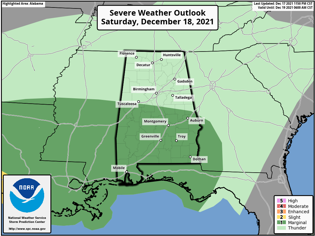
A cold front will move through the area today with showers and storms, but we’ll also have some activity out ahead of the front in the warm and moist sector. We do have just enough instability out ahead of the front that a strong to severe storm is possible, mainly south of a line from Selma to Clanton to Alexander City to Auburn. The Storm Prediction Center has a Marginal Risk for severe storms up for the southern half of the area as there is the potential for isolated damaging wind gusts within any stronger thunderstorm. Tornadoes should not be an issue as the best shear remains out to our west. Highs will be in the lower to mid-70s.
Sunday will be a much calmer day, with much cooler temperatures behind the cold front. It may be breezy at times, as winds may gust up to as high as 20 mph out of the north. Skies will be partly cloudy, with highs reaching the upper 40s to the mid-60s across the area.
A surface low will form and start to move across the Gulf Coast on Monday that will bring a chance of showers to the southern half of the area late on Monday evening and eventually into the rest of Central Alabama on Tuesday. Much of the activity looks to move out of the area before daybreak on Wednesday. Monday’s highs will be in the lower 50s to the lower 60s, while staying in the 50s on Tuesday.
Ridging will begin to build back in over the southeast starting on Wednesday and will continue to strengthen throughout the remainder of the workweek. Skies will be mostly clear on each day with highs in the mid-50s to the lower 60s on Wednesday, upper 50s to the mid-60s on Thursday, and into the lower 60s to the lower 70s on Friday.
BEACH FORECAST
Get the latest weather and rip current forecasts for the beaches from Dauphin Island, AL, to Panama City Beach, FL, on our Beach Forecast Center page. There, you can select the forecast of the region that you are interested in.
ADVERTISE ON THE BLOG
We had a record-breaking year in 2020 with over 20 million page views! We are on a record-shattering pace to break that mark, as we are already over 17.4 million page views through the first half of 2021! Don’t miss out! We can customize a creative, flexible, and affordable package that will suit your organization’s needs. Contact Bill Murray at (205) 687-0782.
E-FORECAST SIGN UP
Get the Alabama Weather Blog’s Seven-Day Forecast delivered directly to your inbox by email twice daily. It is the most detailed weather forecast available in Central Alabama. Subscribe here… It’s free!
CONNECT WITH THE BLOG ON SOCIAL MEDIA
You can find the AlabamaWx Weather Blog on Facebook and Twitter.
WEATHERBRAINS
WeatherBrains is the official netcast for people who love weather featuring our very own James Spann and Bill Murray, along with notable geeks such as Troy Kimmel, Aubrey Urbanowicz, Jen Narramore, Rick Smith, Dr. Neil Jacobs, and Kim Klockow-McClain. They bring together a wealth of weather knowledge and experience for a fascinating netcast about the weather. Watch live starting at 7:00 pm CT on Monday nights at live.bigbrainsmedia.com or live on James Spann’s YouTube channel. Listeners can find the recorded audio versions at WeatherBrains.com or on your favorite podcast platform (Apple Podcasts, Stitcher, Spotify, etc.).
Category: Alabama's Weather, ALL POSTS, Severe Weather, Weather Xtreme Videos
About the Author (Author Profile)
Scott Martin is an operational meteorologist, professional graphic artist, musician, husband, and father. Not only is Scott a member of the National Weather Association, but he is also the Central Alabama Chapter of the NWA president. Scott is also the co-founder of Racecast Weather, which provides forecasts for many racing series across the USA. He also supplies forecasts for the BassMaster Elite Series events including the BassMaster Classic.Subscribe
If you enjoyed this article, subscribe to receive more just like it.


