Cold Start Today; Warmer Days Ahead
COLD START: Here are some temperatures across Alabama just before sunrise…
Gadsden 23
Haleyville 24
Black Creek 24
Pell City 25
Decatur 25
Fort Payne 25
Oxford 26
Hueytown 26
Cullman 27
Talladega 27
Huntsville 27
Anniston 27
Remlap 27
Muscle Shoals 29
Alexander City 29
Prattville 29
Tuscaloosa 30
Selma 30
Birmingham 31
Montgomery 31
Dothan 36
Mobile 38
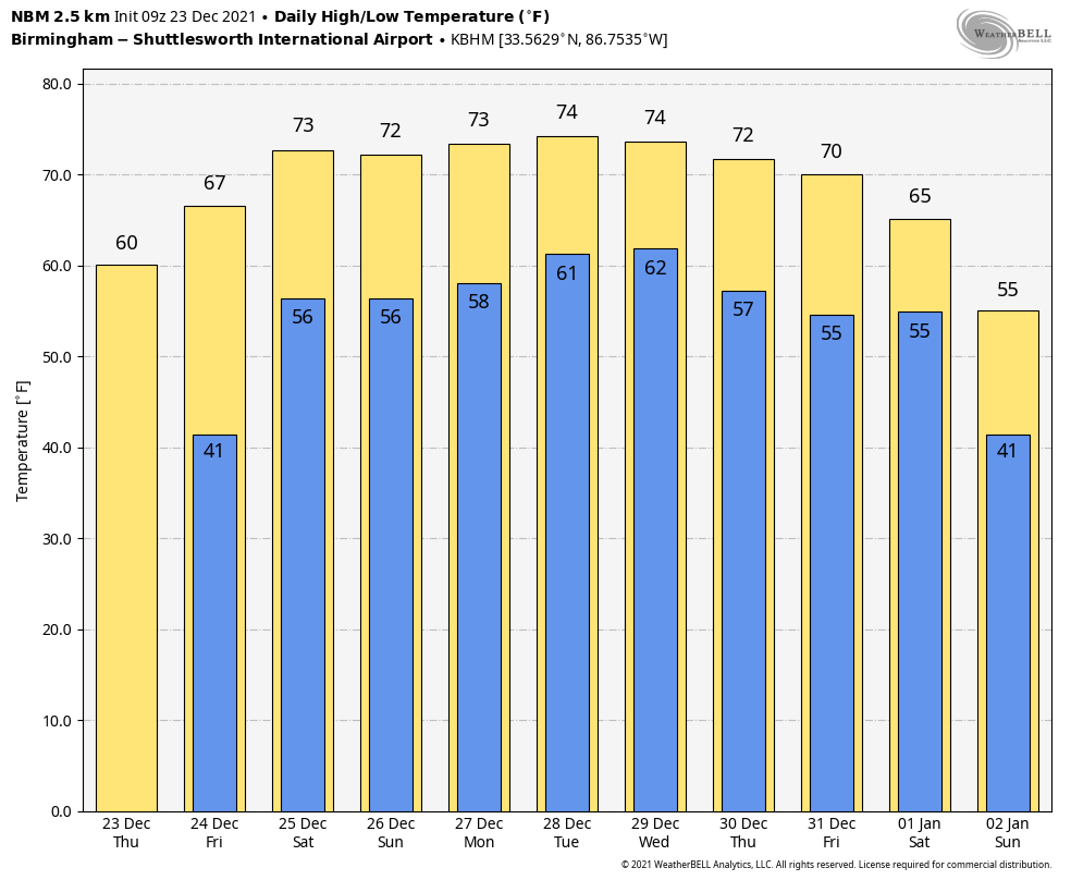
This will be our last morning with sub-freezing temperatures until 2022… a warming trend begins later today as temperatures rise into the low 60s with a sunny sky. Tomorrow will be a partly to mostly sunny day with a high in the upper 60s.
Christmas Day will be dry and warm with a high in the low to mid 70s. The latest NBM (National Blend of Models) is printing a high of 73 degrees for Birmingham Saturday. If we reach that, it will be a tie for the fourth warmest Christmas Day on record (tied with 1982 and 1943, when the high was also 73). Temperatures have reached or exceeded 70 degrees in Birmingham on December 25 ten times since 1900…
2016 78
2015 77
1987 74
1982 73
1942 73
1964 72
1926 71
1922 71
2019 70
1901 70
Sunday will be dry as well… we are forecasting a partly to mostly sunny sky with a high in the low 70s.
NEXT WEEK: The weather will remain unseasonably mild through the week with highs mostly in the low 70s, thanks to an upper ridge over the Gulf Coast region. Moisture levels will rise by mid-week, and we will need to mention a chance of showers Wednesday, Thursday, and possibly Friday. On the positive side, we don’t expect any severe weather issues.
We will continue to watch brutally cold air that will be in place next week over the Northern Plains and the Northwest U.S.. at some point it will have to move, but it will remain north of Alabama for the next 7-10 days, most likely. See the Weather Xtreme video for maps, graphics, and more details.
ON THIS DATE IN 1921: An estimated F3 tornado struck the town of Clarkedale, Arkansas, killing six and injuring 60 others. Four people died in the destruction of the Banks and Danner store, where 50 people were doing their Christmas shopping.
ON THIS DATE IN 1998: A major ice storm struck central and southeast Virginia and much of North Carolina beginning on Wednesday, December 23, and lasting until Christmas Day morning. Icy conditions caused injuries from slips and falls and numerous vehicle accidents. Ice accumulations of up to an inch brought down trees.
ON THIS DATE IN 2015: A violent EF-4 tornado moved along a path from near Holly Springs, MS to Selmer, Tennessee, killing nine people two days before Christmas.
BEACH FORECAST: Click here to see the AlabamaWx Beach Forecast Center page.
WEATHER BRAINS: Don’t forget you can listen to our weekly 90 minute show anytime on your favorite podcast app. This is the show all about weather featuring many familiar voices, including our meteorologists here at ABC 33/40.
CONNECT: You can find me on all of the major social networks…
Look for the next Weather Xtreme video here by 3:00 this afternoon… enjoy the day!
Category: Alabama's Weather, ALL POSTS, Weather Xtreme Videos
About the Author (Author Profile)
James Spann is one of the most recognized and trusted television meteorologists in the industry. He holds the AMS CCM designation and television seals from the AMS and NWA. He is a past winner of the Broadcast Meteorologist of the Year from both professional organizations.Subscribe
If you enjoyed this article, subscribe to receive more just like it.


