SPC Mesoscale Discussion — Moisture Levels Will Play a Major Role in Tornado Risk Over the Next Couple of Hours
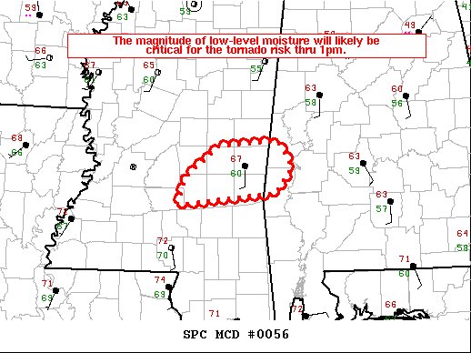
Storms have begun to organize during the past hour over the central parts of Mississippi. The amount of low-level moisture, and whether that richer moisture reaches the I-20 corridor, will likely prove critical for the tornado risk over the next 1-2 hours. Here is the latest Mesoscale Discussion text:
Radar imagery from KDGX (Jackson, MS) shows a south-southwest to north-northeast band of intensifying thunderstorms (echo tops increasing to 35-40 kft) as storms begin to organize. The primary uncertainty for tornado development during the next 1-2 hours is the richness of low-level moisture immediately ahead of the thunderstorms. Surface observations show temperatures in the upper 60s at Hattiesburg/Laurel, MS, with upper 60s dewpoints. Farther northeast, only a 60 deg F dewpoint was recorded at Meridian, MS as of 10am CST. A maritime warm front is advancing northward between the two cities, and it is uncertain whether the richer moisture will advect northward in time to be available within the inflow of the developing storms. If this richer moisture does manage to reach near the I-20 corridor, it would seem the greater buoyancy available would support an increased risk for a tornado, in addition to isolated damaging gusts.
Category: Alabama's Weather, ALL POSTS, Severe Weather
About the Author (Author Profile)
Scott Martin is an operational meteorologist, professional graphic artist, musician, husband, and father. Not only is Scott a member of the National Weather Association, but he is also the Central Alabama Chapter of the NWA president. Scott is also the co-founder of Racecast Weather, which provides forecasts for many racing series across the USA. He also supplies forecasts for the BassMaster Elite Series events including the BassMaster Classic.Subscribe
If you enjoyed this article, subscribe to receive more just like it.


