Midday Nowcast: Another Sunny and Chilly Day
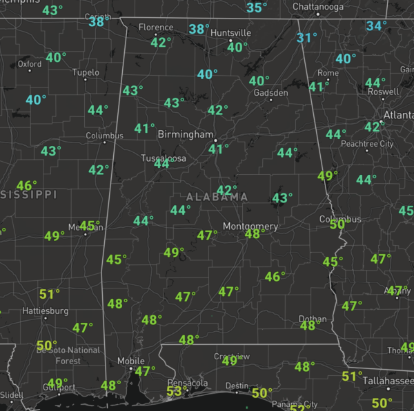
It is another sunny and cool day across Alabama as we remain under the influence of high pressure centered to our northwest today. Temperatures today are in the 40s late this morning and will be struggling to reach the 50° mark for many locations this afternoon.
The highs slides east tomorrow, and that will at least allow for temperatures to return to the 50s the rest of the week, which is right at seasonal averages. Thursday and Friday will feature a few more clouds and overnight lows this week will be in the 30s.
USA BRIEF: Chilly airmass will move over the Northeast where there will be dangerously cold wind chill temperatures. Heavy rainfall may bring flooding and landslide risks in Washington across the Olympic Peninsula and Northern Cascades today; and freezing rain is expected east of the Cascades. Gusty winds may cause hazardous travel in Montana and Wyoming through Wednesday.
THE ALABAMA WEEKEND: Clouds return Saturday and now it looks like the scattered showers return to the area Saturday and night and Sunday morning as a shortwave trough work across Alabama. There won’t be any instability so storms are not in the forecast, and moisture will be limited, so rain amounts will be light (generally under 1/2 inch). Highs Saturday will be in the 50s, but colder air returns Sunday with highs in the 40s.
As James said this morning, there could be enough moisture in place as colder air returns to Alabama that we could see some wintry precip as the system departs Sunday over the northern third of Alabama. For now there is only a low chance of any accumulation or impact. As always, watch for forecast changes as we get closer to the weekend.
NEXT WEEK: Monday will be cold and dry with highs in the 40s. Temperatures return to the 50s Tuesday and Wednesday, and rain looks to return to Alabama next Thursday.
?BEACH FORECAST CENTER: Get the latest weather and rip current forecasts for the beaches from Fort Morgan to Panama City on our Beach Forecast Center page. There, you can select the forecast of the region that you are interested in visiting.
WORLD TEMPERATURE EXTREMES: Over the last 24 hours, the highest observation outside the U.S. was 115.7F at Rabbit Flat, Australia. The lowest observation was -57.6F at Dawson Yukon Territory, Canada.
CONTIGUOUS TEMPERATURE EXTREMES: Over the last 24 hours, the highest observation was 87F at Fort Myers, FL. The lowest observation was -31F at Mount Washington, NH.
WEATHER ON THIS DATE IN 1918: A tremendous blizzard completely immobilized the Midwest, stopping mail service for two weeks. The vast storm then moved through the Great Lakes Region and the Ohio Valley. Winds reached 60 mph at Toledo OH, and the temperature plunged from 28 above to 15 below zero during passage of the cold front.
Category: Alabama's Weather, ALL POSTS
About the Author (Author Profile)
Macon, Georgia Television Chief Meteorologist, Birmingham native, and long time Contributor on AlabamaWX. Stormchaser. I did not choose Weather, it chose Me. College Football Fanatic. @Ryan_StinnetSubscribe
If you enjoyed this article, subscribe to receive more just like it.


