Rain Returns This Weekend; Will We See Some Snow????
SEVERE CLEAR: Not a cloud in the Alabama sky this afternoon… with sunshine in full supply temperatures are mostly in the 45-52 degree range. Tonight will be clear and cold again with a low between 25 and 34 degrees.
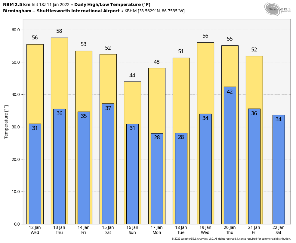
The rest of the week will be dry with seasonal temperatures; highs mostly in the 50s and lows in the 30s. The focus is clearing on the system that will impact the Southeast U.S. over the weekend.
SATURDAY: Clouds will increase during the day with a high in the 50s; rain could reach West Alabama by late afternoon. Then, rain becomes likely statewide Saturday night into Sunday.
Global models continue to show some potential for some snow in the mix of parts of North Alabama with this system, but there remains considerable inconsistency in model output, which is to be expected 5 days out. At this stage, it is best to use the ensemble approach. Multiple model simulations are run, each with a slight variation of its initial conditions… they produce a range of possible weather outcomes. We then take the mean of the ensemble members for a look at what might happen.
For now, using the European global model ensemble output, the greatest chance of a major winter storm are northeast of Alabama. The probability of one inch or more of snow is running in the 30-50 percent range over East and Northeast Alabama, with lower probabilities elsewhere. A meaningful winter storm seems likely for parts of North Georgia and the Carolinas.
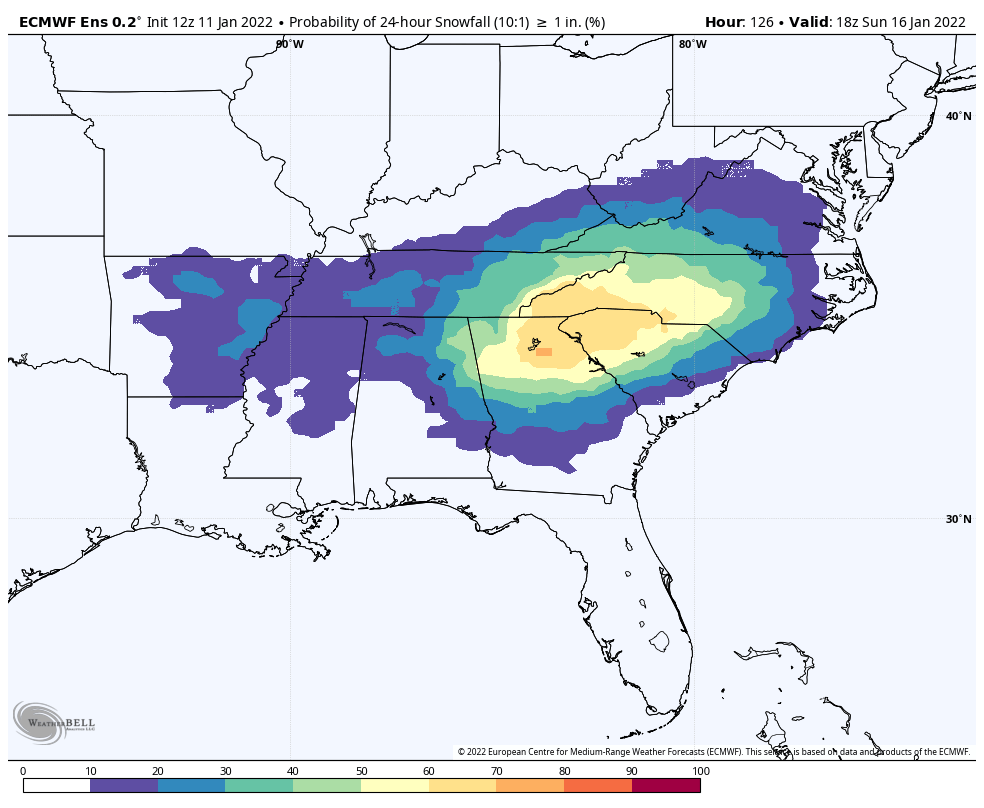
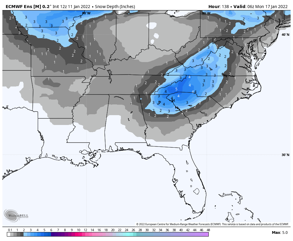
We will need a strong system with dynamic cooling for significant snow in Alabama from this system since the initial thermal values are very marginal for snow. For now we will continue to forecast rain for most of the state Saturday night and Sunday, with potential for a brief change to snow on the back side of the system with only light snow amounts. But, understand this forecast could easily change as the weekend gets closer.
NEXT WEEK: The first half of the week looks dry… rain returns Thursday. The high Monday will be in the 40s… then we expect 50s for the rest of the week. See the Weather Xtreme video for maps, graphics, and more details.
ON THIS DATE IN 1885: Five documented strong/violent tornadoes struck Alabama during the evening hours of January 11, 1885. These tornadoes affected at least 15 separate counties across the state from approximately 5 pm until after 11 pm. At least ten were killed, and many more were hurt. The longest track tornado moved through parts of Greene, Hale, Bibb, and Chilton counties.
ON THIS DATE IN 1918: A powerful tornado destroyed the small town of Webb, near Dothan in Southeast Alabama. The tornado leveled one rural school, killing one teacher and seven students. One man was killed in the collapse of his store, and about 70 people were hurt at Webb. A woman was killed in her home. To the north, Birmingham measured one inch of snow in colder air over the northern half of the state.
BEACH FORECAST: Click here to see the AlabamaWx Beach Forecast Center page.
WEATHER BRAINS: Don’t forget you can listen to our weekly 90 minute show anytime on your favorite podcast app. This is the show all about weather featuring many familiar voices, including our meteorologists here at ABC 33/40.
CONNECT: You can find me on all of the major social networks…
Look for the next Weather Xtreme video here by 6:00 a.m. tomorrow…
Category: Alabama's Weather, ALL POSTS, Weather Xtreme Videos
About the Author (Author Profile)
James Spann is one of the most recognized and trusted television meteorologists in the industry. He holds the AMS CCM designation and television seals from the AMS and NWA. He is a past winner of the Broadcast Meteorologist of the Year from both professional organizations.Subscribe
If you enjoyed this article, subscribe to receive more just like it.


