Messy Weekend Ahead With Rain/Snow For Alabama
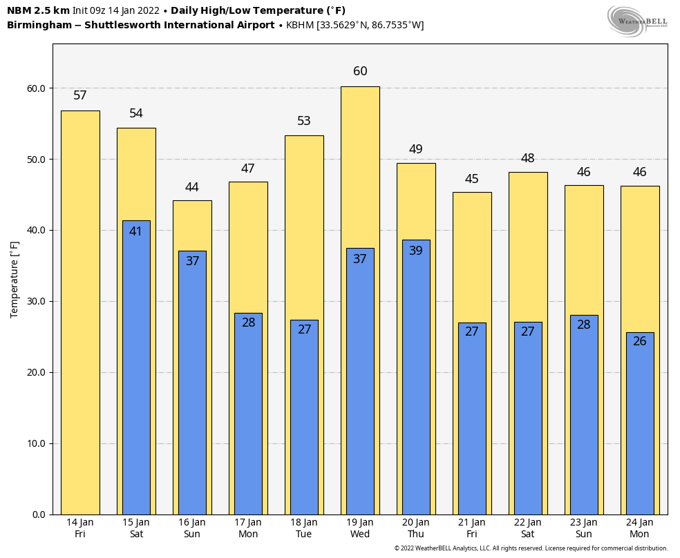
ONE MORE DRY DAY: Look for a partly to mostly sunny sky across Alabama today with a high in the mid to upper 50s for most communities. Clouds will thicken tonight ahead of the approaching storm system.
TOMORROW: Rain will move into the western counties of the state by midday, and widespread rain is likely statewide tomorrow evening and tomorrow night. This will be a good soaking, with amounts of 1-2 inches likely. A few strong thunderstorms are possible along the Gulf Coast… the has defined a “marginal risk” (level 1/5) of severe thunderstorms along the Florida coast from Perdido Key all the way down to Sarasota.
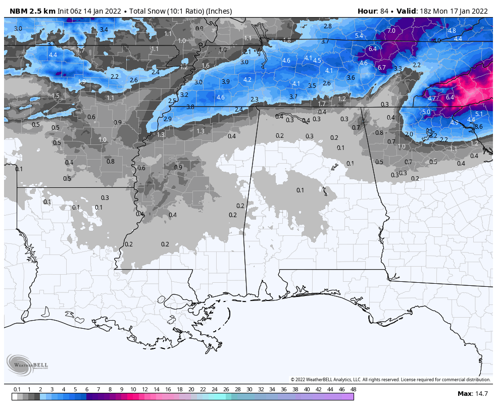
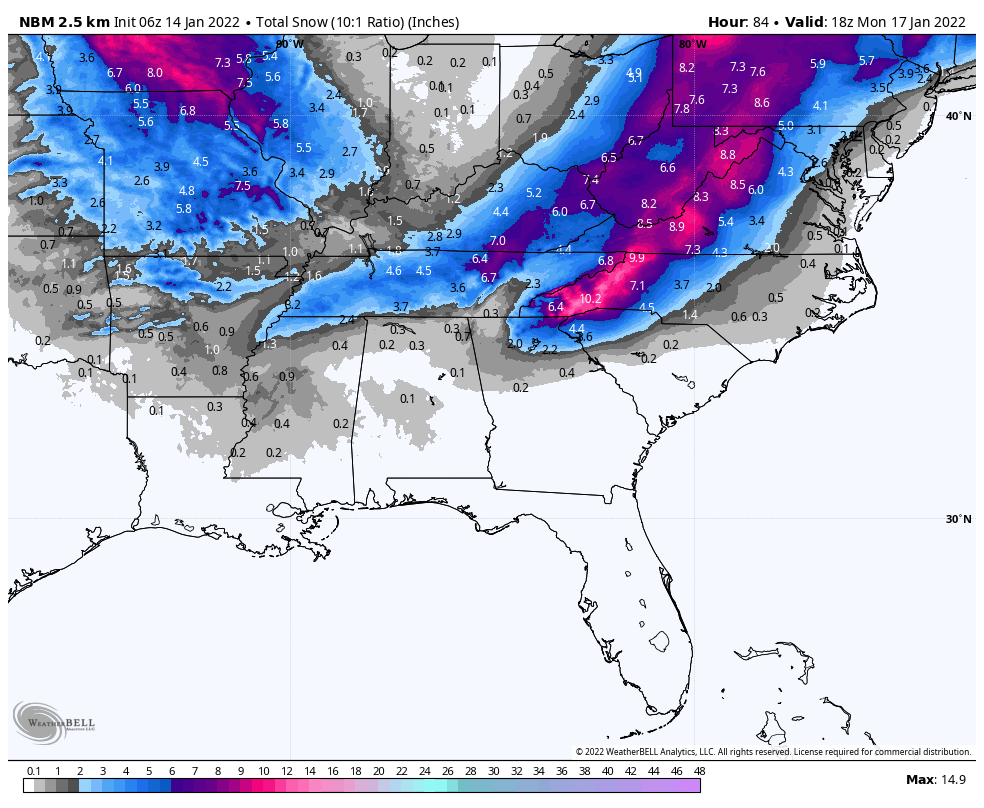
SNOW POTENTIAL SUNDAY: Much colder air will be pulled southward Sunday, and the rain will likely chance to periods of snow over the northern half of the state. Some accumulation is possible on grassy areas over about the northern third of Alabama (north of Birmingham)… amounts should be generally one inch or less. However, isolated heavier totals are possible north of the Tennessee River, and across the high terrain of northeast Alabama.
Temperatures will be generally in the mid 30s Sunday as the snow falls, and with temperatures holding just above freezing roads should be just wet, and for now travel impact is not expected Sunday afternoon. However, as temperatures drop below freezing Sunday night some patchy “black ice” is possible mainly on bridges.
While there are no watches for any part of Alabama, a winter storm watch is in effect for much of Tennessee, where snow amounts of 2-4″ are likely. Major snow and ice impacts are also likely in the Carolinas, Virginia, and West Virginia.
As always, know this forecast can change, so watch for updates over the weekend.
NEXT WEEK: Monday and Tuesday will be dry with a warming trend… then a cold front will bring a chance of rain Wednesday afternoon and Wednesday night. Another shot of cold, dry air rolls into the state Thursday and Friday. See the Weather Xtreme video for maps, graphics, and more details.
ON THIS DATE IN 1963: Birmingham dropped to 13 degrees as a cold wave was underway across the Deep South.
ON THIS DATE IN 1972: In Loma, Montana, the temperature soared from 54 degrees below zero to 49 degrees above zero on January 14-15, 1972. The 103-degree change is the greatest ever recorded in the world for a 24 hour period.
BEACH FORECAST: Click here to see the AlabamaWx Beach Forecast Center page.
WEATHER BRAINS: Don’t forget you can listen to our weekly 90 minute show anytime on your favorite podcast app. This is the show all about weather featuring many familiar voices, including our meteorologists here at ABC 33/40.
CONNECT: You can find me on all of the major social networks…
Look for the next Weather Xtreme video here by 3:00 this afternoon… enjoy the day!
Category: Alabama's Weather, ALL POSTS, Weather Xtreme Videos
About the Author (Author Profile)
James Spann is one of the most recognized and trusted television meteorologists in the industry. He holds the AMS CCM designation and television seals from the AMS and NWA. He is a past winner of the Broadcast Meteorologist of the Year from both professional organizations.Subscribe
If you enjoyed this article, subscribe to receive more just like it.


