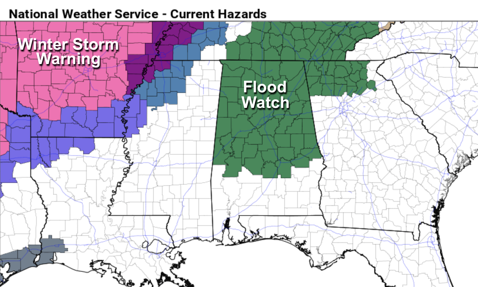
Wet Through Friday; Flood Watch Issued
WET: Expect waves of rain across Alabama through Friday as a very wet pattern develops. A flood watch has been issued for the northern 2/3 of the state tonight through tomorrow night; rain amounts of 2-4 inches are expected with potential for some flooding issues.
A few strong thunderstorms are possible across parts of West and Southwest Alabama tomorrow and tomorrow night; SPC has defined a “marginal risk” (level 1/5) for the broad area from Tuscaloosa to Mobile and the Gulf Coast.
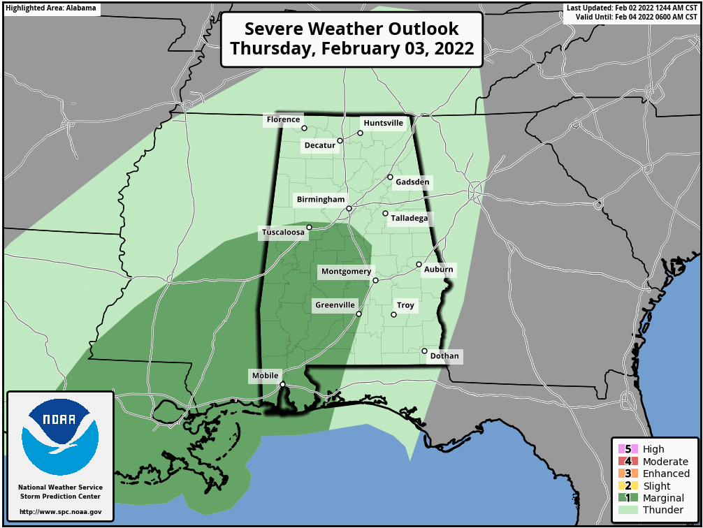
The main threat in Alabama will come from strong gusty winds; there is a low end tornado threat to the west over parts of South Mississippi and Southeast Louisiana.
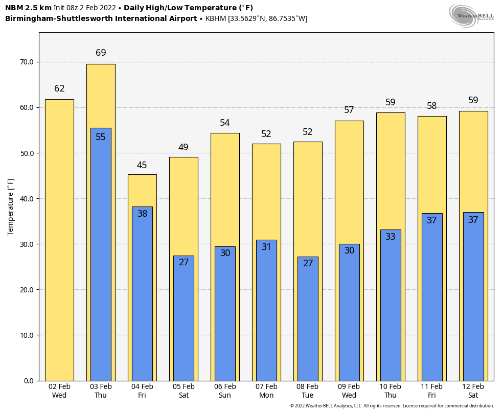
The high today will be around 60, followed by upper 60s tomorrow. Then, on Friday, the day will be sharply colder with temperatures holding in the 30s over the northern third of the state. By Friday afternoon the best chance of rain will shift down into South Alabama.
THE ALABAMA WEEKEND: Saturday will be mostly cloudy with a high in the mid to upper 40s. A wave could squeeze out a few sprinkles or flurries late in the day or Saturday night, but probably nothing significant. Then, on Sunday, expect a clearing sky with a high in the mid 50s.
NEXT WEEK: For now the week looks dry with seasonal temperatures… highs in the 50s, lows in the 30s. See the Weather Xtreme video for maps, graphics, and more details.
TO THE NORTH: A major winter storm will bring snow and ice from Texas to northern New England. An ice storm warning has been issued for the Memphis area, where ice accumulation could exceed a quarter of an inch in spots… power outages are possible there. But all of this wintry precipitation will stay north of Alabama.
ON THIS DATE IN 1985: North Alabama was in the midst of a severe ice storm. During the event, up to eleven inches of ice and sleet would accumulate in Florence, making it the worst storm there since the big New Years’ Eve snowstorm in 1963. the brunt of the storm impacted areas north and northwest of Birmingham, including much of Lauderdale, Colbert, Franklin, Lawrence, Limestone, Madison, Morgan, Cullman, Winston and parts of Walker County. A total of twenty buildings collapsed under the weight of the ice.
This was part of an Arctic outbreak that lasted from late January through early February 1985 produced nearly 400 hundred record lows, 15 all-time low readings, and over 50 new record lows. Four states recorded their all-time record low temperatures, including Tower, Minnesota, on this date with a reading of 60 degrees below zero, canceling Tower’s annual Icebox Days festival because it is too cold. Locations that reported their all-time record low or tied included: Cresco, IA: -36°, Osage, IA: -34°, Charles City, IA tied their record low with -32° and Lancaster, WI tied their all-time record low with -31°. International Falls, MN, and Glasgow, MT set records for February with -45° and -38°, respectively.
BEACH FORECAST: Click here to see the AlabamaWx Beach Forecast Center page.
WEATHER BRAINS: Don’t forget you can listen to our weekly 90 minute show anytime on your favorite podcast app. This is the show all about weather featuring many familiar voices, including our meteorologists here at ABC 33/40.
CONNECT: You can find me on all of the major social networks…
Look for the next Weather Xtreme video here by 3:00 this afternoon… enjoy the day!
Category: Alabama's Weather, ALL POSTS, Weather Xtreme Videos
About the Author (Author Profile)
James Spann is one of the most recognized and trusted television meteorologists in the industry. He holds the AMS CCM designation and television seals from the AMS and NWA. He is a past winner of the Broadcast Meteorologist of the Year from both professional organizations.Subscribe
If you enjoyed this article, subscribe to receive more just like it.


