Midday Nowcast: Watching Developments to Our West
It is a warm day with temperatures climbing into the low to mid 70s. Our winds continue to increase as well, these gradient winds (not related to thunderstorms) will average 15-35 mph out of the south, with potential for gusts to 45-50 mph. These alone can cause tree and power issues, and for that reason, a Wind Advisory is in effect.
To our west, we are watching showers and storms develop ahead of the cold front, and these will be arriving in Alabama later this afternoon and evening. In fact, at the writing of this forecast, late this morning, a Tornado Watch will soon be issued across much of Mississippi.
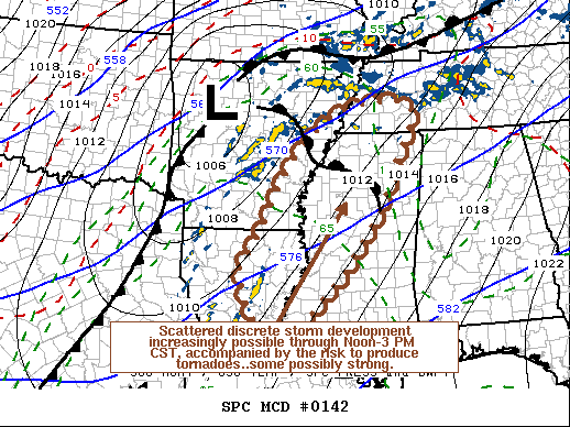
This is where the potential for scattered discrete supercell development appears likely to increase near and east of the Mississippi River by around Noon through 3 PM CST. These storms will pose a risk of producing tornadoes, at least a couple of which could become strong.
PLACEMENT: Late morning update, the SPC maintains an “enhanced risk” (level 3/5) of severe thunderstorms for parts of North and West Alabama… west of a line from Hytop to Sumiton to Brookwood to Demopolis. A “slight risk” (level 2) extends as far east as Anniston, Prattville, and Grove Hill, and the rest of the state (East/South Alabama) is in a “marginal risk” (level 1/5).
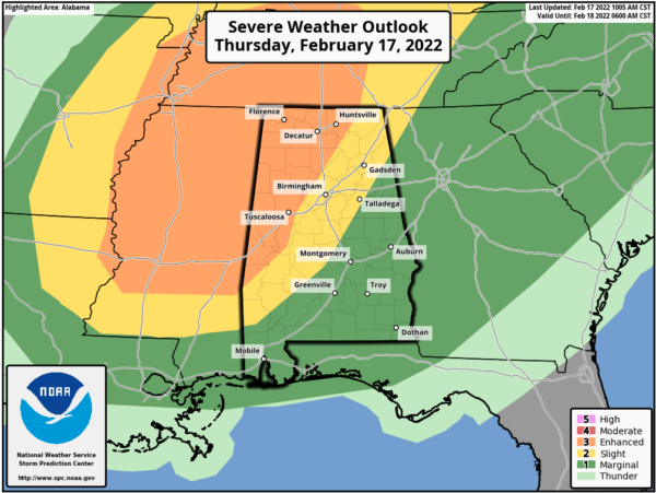
TIMING: The main window for severe storms in Alabama will come from 2PM in Northwest Alabama through 12AM in Southeast Alabama. For places like Birmingham, Tuscaloosa, Anniston, and Gadsden, the core threat comes through the evening hours, 5PM-9PM.
THREATS: Storms today will be capable of producing hail, damaging straight-line winds, and a few tornadoes. The highest tornado threat is in the “enhanced risk” area across North and West Alabama, and a strong tornado (EF-2 or higher) can’t be ruled out. However, don’t for focus on colors on the map, know that all of Alabama under a risk for severe storms capable of producing tornadoes.
RAIN: Rain amounts of around one inch are likely, but flooding is not expected to be an issue for now as the system will be moving very quickly through the state.
CALL TO ACTION: Again, this is not uncommon for this time of year…Be prepared and make sure you have all aspects of your severe weather safety plan ready for action. Be sure you have a way of hearing severe weather warnings, and an action plan if you are in a tornado warning polygon, take severe thunderstorm warnings seriously too. Have a NOAA Weather Radio in your home and business, properly programmed with a fresh battery in case of power failure. Be sure WEA (Wireless Emergency Alerts) enabled on your phone…this is not an app, but built into every phone sold in the U.S. Check settings, and notifications, and be sure emergency alerts are on. Have the free ABC 33/40 weather app on your phone as a secondary way of getting warnings. Search the App Store for “ABC 33/40 Weather” if you don’t have it already.
In a site built home, identify the safe place. Small room, lowest floor, near the center of the house, away from windows. And, in that safe place, have helmets for everyone in the family (including adults!), portable air horns, and hard sole shoes. You CANNOT stay in a mobile home if you are in a tornado warning polygon. Know the closest shelter, and how to get there quickly.
Sheltering from a tornado is first priority when it comes to the COVID-19 situation. A tornado is an immediate threat to life; get to your safe place or shelter and do the best you can to protect yourself from exposure to the virus.
BE A HERO: You can help us. Tell your friends, neighbors, and relatives about the threat, and what they need to do to get ready. If you know someone that is in a tornado warning polygon, be sure and call or text them to let them know of the danger, and to turn on our live coverage. There are many we can’t reach… ones that don’t watch our coverage, or don’t pay attention to weather. You are our most valuable resource in spreading the word!
FRIDAY AND THE WEEKEND: The sky becomes sunny Friday, and the day will be cooler with a high in the low 50s. Dry weather continues over the weekend for most of Alabama with mostly sunny days and fair nights; the high Saturday will be in the mid 50s, followed by mid 60s Sunday.
NEXT WEEK: Much of next week looks rather wet at times, with rain amounts in the 1-2 inch range look likely Monday through Friday. Too early to know if we will see any severe weather threat. The week will be mild as temperatures most days will reach the 70s in many places.
BEACH FORECAST: Click here to see the AlabamaWx Beach Forecast Center page.
Category: Alabama's Weather, ALL POSTS, Severe Weather
About the Author (Author Profile)
Macon, Georgia Television Chief Meteorologist, Birmingham native, and long time Contributor on AlabamaWX. Stormchaser. I did not choose Weather, it chose Me. College Football Fanatic. @Ryan_StinnetSubscribe
If you enjoyed this article, subscribe to receive more just like it.


