Midday Nowcast: Rainy Days and Mondays
That 1973 Carpenters’ hit applies perfectly to the weather today as a northward moving warm front is producing periods of rain and storms across Alabama today.
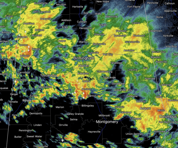
It is a chilly day due to the clouds and rain, highs today are ranging from the low 50s to lower 60s.
SPRING-LIKE WARMTH: As the warm front moves north of the area this week, we are going to see temperatures surge into the 70s statewide with some lower 80s across South Alabama tomorrow and Wednesday. It looks like a decent part of tomorrow will be dry with a mix of sun and clouds with isolated showers. Late tomorrow and into tomorrow night, showers and storms are likely ahead of a wave of low pressure pushing a cold front towards Alabama, and some strong storms are possible.
The SPC has defined a “slight risk” (level 2/5) of severe thunderstorms west of a line from Madison to Carbon Hill to Aliceville. A “marginal risk” (level 1/5) extends as far east as Fort Payne, Alabaster, and Thomasville.
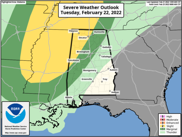
The core threat will come from strong straight line winds tomorrow evening, although an isolated tornado or two can’t be totally rule out, especially in the “slight risk” over Northwest Alabama. Some hail is possible as well. For now the it looks like core severe weather threat will come from about 6PM midnight. As always, be sure you can hear warnings if they are needed.
CONTINUED WARMTH: Although the front pushes into the state, it will not make it very far due to a ridge south of the area blocking it, allowing for a very mild Wednesday and Thursday with highs in the 70s. A few showers are possible both days, but the rain won’t be especially widespread or heavy.
As we head into Thursday night, the ridge to weakens and the front will finally makes it way south, bring more rain and storms to the state Thursday night into Friday morning. There could be a few strong storms with the front, but for now the odds of organized severe weather look low, but of course we will monitor trends in the coming days.
The rain should end early Friday, but behind the front, it will be colder with temperatures likely in the 40s, with lingering clouds.
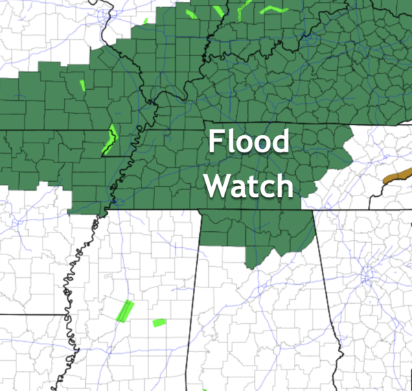
SOAKING RAINS: Rain amounts between now and Friday will be in the 2-4 inch range over the Tennessee Valley of far North Alabama, where a flood watch is effect for area around Cullman, Huntsville, Florence, Decatur, Scottsboro and Athens; 1-2 inches likely for places like Birmingham/Tuscaloosa/Anniston/Gadsden. Amounts will be under one inch for much of South Alabama.
THE ALABAMA WEEKEND: The day Saturday looks cool and dry with highs remaining in the upper 40s and low 50s. Then, a wave on the front to the south will bring more rain to the state Saturday night and early Sunday morning. Then, some clearing is likely by Sunday afternoon with a high in the low 50s.
BEACH FORECAST CENTER: Get the latest weather and rip current forecasts for the beaches from Fort Morgan to Panama City on our Beach Forecast Center page. There, you can select the forecast of the region that you are interested in visiting.
WORLD TEMPERATURE EXTREMES: Over the last 24 hours, the highest observation outside the U.S. was 109.9F at Mardie, Australia. The lowest observation was -64.5F at Delyankir, Russia.
CONTIGUOUS TEMPERATURE EXTREMES: Over the last 24 hours, the highest observation was 85F at Naples and Ft. Myers, FL. The lowest observation was -19F at Mount Washington, NH.
WEATHER ON THIS DATE IN 1971: An outbreak of tornadoes hit northeastern Louisiana and northern and central Mississippi. The tornadoes claimed 121 lives, including 110 in Mississippi. Three tornadoes accounted for 118 of the deaths. There are 1600 persons injured, 900 homes were destroyed or badly damaged, and total damage was 19 million dollars.
Category: Alabama's Weather, ALL POSTS
About the Author (Author Profile)
Macon, Georgia Television Chief Meteorologist, Birmingham native, and long time Contributor on AlabamaWX. Stormchaser. I did not choose Weather, it chose Me. College Football Fanatic. @Ryan_StinnetSubscribe
If you enjoyed this article, subscribe to receive more just like it.


