Warmer Tomorrow; Strong/Severe Storms Possible Tomorrow Evening
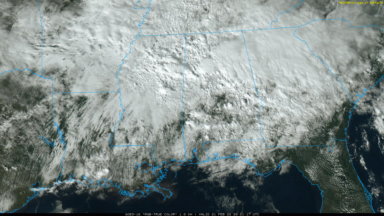
RADAR CHECK: Widespread rain continues over much of Alabama this afternoon… generally north of a line from Tuscaloosa to Eufaula. The rain is north of a warm front positioned over the southern part of the state; south of the warm front temperatures are in the 70s, but north of the front where rain is falling readings are in the 47-55 degree range.
The front will move northward tonight, and rain will diminish from the south.
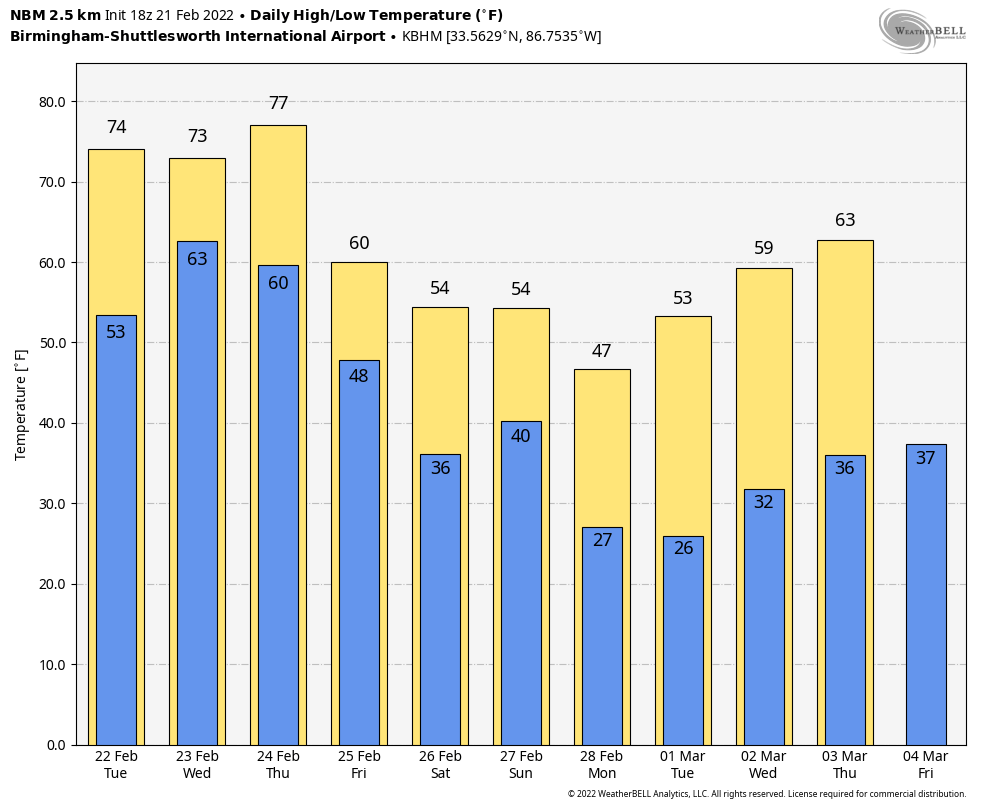
TOMORROW: While a few showers are possible, much of the morning should be dry with temperatures rising into the 70s by afternoon. Then, the front to the north will move southward again, setting the stage for strong to severe thunderstorms tomorrow evening. SPC maintains a “slight risk” (level 2/5) of severe thunderstorms for areas west of a line from Huntsville to Jasper to Aliceville. A “marginal risk” (level 1/5) extends as far east as Fort Payne, Alabaster, and Thomasville.
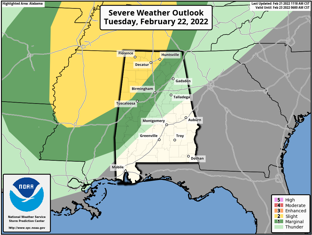
TIMING: The window for strong to severe thunderstorms is roughly from 4:00 p.m. until 11:00 p.m. tomorrow.
THREATS: Stronger storms will be capable of producing large hail, strong winds, and a few isolated tornadoes. The higher tornado probabilities are over the “slight risk” area of North and West Alabama.
RAIN: Additional rain amounts of around one inch are likely late tomorrow and tomorrow night. NWS Huntsville has issued a flash flood watch for the counties in the Tennessee Valley of North Alabama.
As always, be sure you can hear severe weather warnings in the event they are needed.
WEDNESDAY THROUGH FRIDAY: A complex pattern continues. We will mention some risk of scattered showers Wednesday and Thursday, but the rain won’t be especially heavy or widespread. The high Wednesday will be in the upper 60s, followed by mid to upper 70s Thursday. A few spots could touch 80 degrees Thursday afternoon for the first time this year.
Then, the front will push southward again with rain and storms likely late Thursday night into Friday morning. For now the overall severe weather risk looks low; additional rain amounts of 1 inch are expected with this round. Then, Friday will be sharply colder with a high in the 48-52 degree range. Some clearing is possible Friday afternoon.
THE ALABAMA WEEKEND: Much of the day Saturday will be dry and cool with some sun possible…. the high will be in the low 50s More rain is likely Saturday night as another wave moves along the front to the south. Then, on Sunday, expect a clearing sky with a high around 50.
NEXT WEEK: For now much of the week looks dry with temperatures about 5-10 degrees below average most days… See the Weather Xtreme video for maps, graphics, and more details.
ON THIS DATE IN 1971: A tornado outbreak occurred in the Delta region of northeastern Louisiana and Mississippi. The first significant tornado touched down at about 2:50 p.m. in Louisiana and crossed into Mississippi. 46 were killed by this twister, which struck the towns of Dehli and Inverness. 121 people lost their lives that day, including 110 in Mississippi. A total of 1600 people were injured, 900 homes severely damaged or destroyed. The total loss was around 19 million dollars.
BEACH FORECAST: Click here to see the AlabamaWx Beach Forecast Center page.
WEATHER BRAINS: Don’t forget you can listen to our weekly 90 minute show anytime on your favorite podcast app. This is the show all about weather featuring many familiar voices, including our meteorologists here at ABC 33/40.
CONNECT: You can find me on all of the major social networks…
Look for the next Weather Xtreme video here by 6:00 a.m. tomorrow…
Category: Alabama's Weather, ALL POSTS, Weather Xtreme Videos
About the Author (Author Profile)
James Spann is one of the most recognized and trusted television meteorologists in the industry. He holds the AMS CCM designation and television seals from the AMS and NWA. He is a past winner of the Broadcast Meteorologist of the Year from both professional organizations.Subscribe
If you enjoyed this article, subscribe to receive more just like it.


