Rain Ends Later This Morning; Clouds Linger
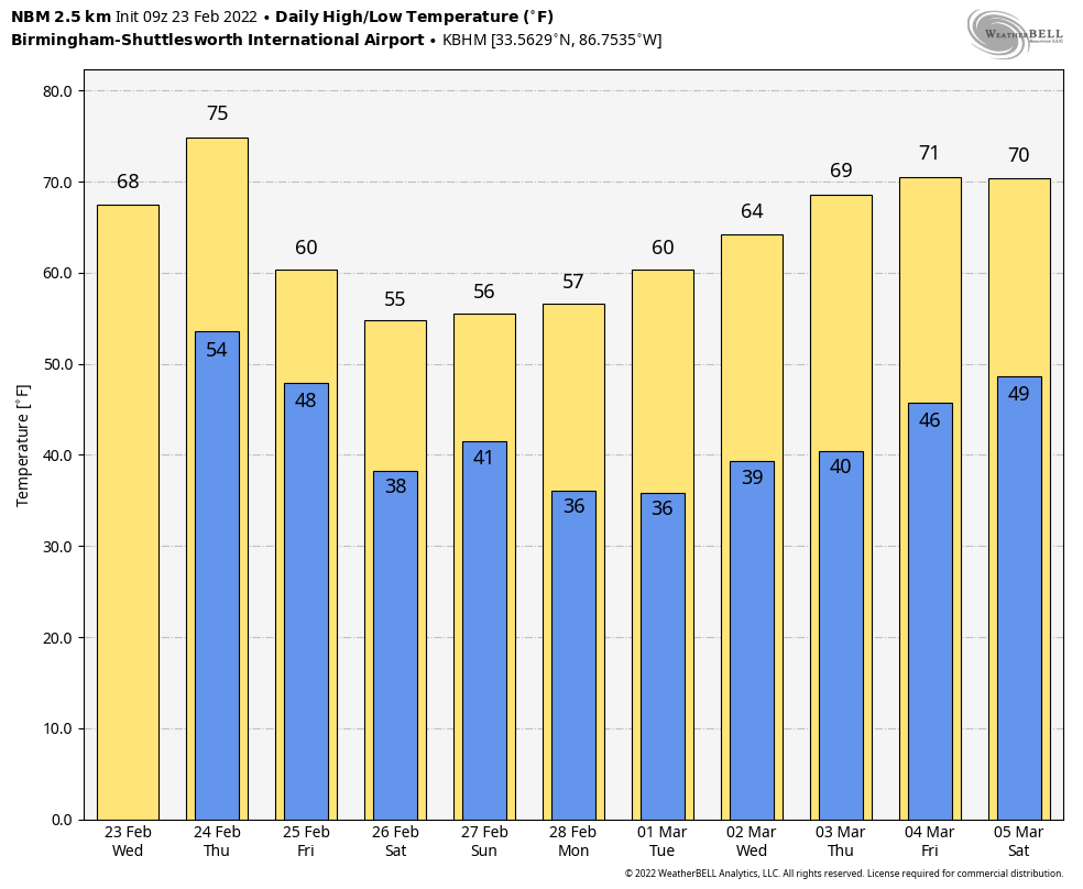
RADAR CHECK: Widespread rain continues across parts of North/Central Alabama early this morning ahead of a cold front that is lined up from near Huntsville to Fayette at 6:00 a.m. The front will sag southward, and become stationary over the central counties later this morning as it becomes parallel to the upper air winds. Rain will end over the northern half of the state, and any showers this afternoon will be over South Alabama… and there they will be widely scattered. The high today will be in the 40s and 50s over the northwest corner of the state, 60s for the rest of North/Central Alabama, and 70s to the south.
The flash flood watch that has been in effect for North Alabama will expire later this morning.
REST OF THE WEEK: The front lifts northward as a warm front tonight, and tomorrow will be a warm February day with a high in the mid to upper 70s for most places. Look for a mix of sun and clouds, and most places will be dry with only isolated showers. The front returns southward as a cold front tomorrow night, and rain is likely over the northern half of the state late tomorrow night into Friday morning. There could be a rumble of thunder in spots, but no severe storms are expected. Some clearing is possible Friday afternoon with temperatures in the low to mid 50s.
THE ALABAMA WEEKEND: Saturday will be mostly and cool with daytime temperatures in the 48-54 degree range over the northern half of the state. Showers are possible mainly over the Tennessee Valley of North Alabama. Then, rain becomes more widespread Saturday night and Sunday morning over North/Central Alabama as a wave of low pressure moves along the front that remains draped over the state. Drier air returns Sunday afternoon with a high in the mid 50s.
NEXT WEEK: The week looks dry with a warming trend; afternoon temperatures rise to near 70 degrees by Thursday and Friday. See the Weather Xtreme video for maps, graphics, and more details.
ON THIS DATE IN 1975: An F4 tornado tore through parts of the city of Tuscaloosa, killing one person. It first touched down in the Taylorville community and then skipped northeastward before hitting the Skyland Park area and moving on to McFarland Blvd near the intersection of I-59/20. It went on to affect parts of the Alberta City and Holt. The official path length was 14.4 miles. Along it, 289 homes were destroyed or heavily damaged, along with 20 businesses and 21 mobile homes. The tornado nearly destroyed the new Scottish Inn motel on I-59 at McFarland. The fatality was a 23 year old housekeeper named Thelma Hill, killed when most of the second floor of the motel was sheared away by the tornado causing a wall to fall on her.
BEACH FORECAST: Click here to see the AlabamaWx Beach Forecast Center page.
WEATHER BRAINS: Don’t forget you can listen to our weekly 90 minute show anytime on your favorite podcast app. This is the show all about weather featuring many familiar voices, including our meteorologists here at ABC 33/40.
CONNECT: You can find me on all of the major social networks…
Look for the next Weather Xtreme video here by 3:00 this afternoon… enjoy the day!
Category: Alabama's Weather, ALL POSTS, Weather Xtreme Videos
About the Author (Author Profile)
James Spann is one of the most recognized and trusted television meteorologists in the industry. He holds the AMS CCM designation and television seals from the AMS and NWA. He is a past winner of the Broadcast Meteorologist of the Year from both professional organizations.Subscribe
If you enjoyed this article, subscribe to receive more just like it.


