Rain Moves Back In Later Today; Late Season Freeze This Weekend
RADAR CHECK: Showers are increasing along and north of a stalled surface front over South Alabama early this morning. A wave of low pressure forms along the front today, and rain becomes widespread statewide this afternoon and tonight. The air will be cool and stable over most of the state (highs will be in the 50s today north of the front), but SPC has defined a low end “marginal risk” of severe thunderstorms for Mobile and Baldwin counties, and some of the adjacent counties.
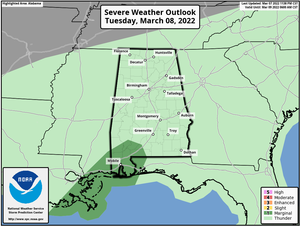
A few storms over the southwest corner of Alabama could produce strong gusty winds tonight.
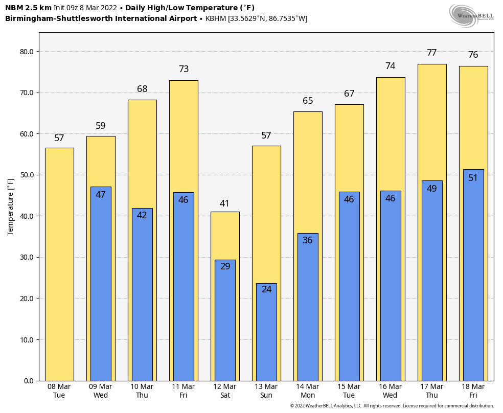
Rain will end tomorrow morning for most places, and by afternoon the rain will be confined to the far southern part of Alabama. Otherwise, tomorrow will be cloudy with a high in the mid to upper 50s for most places.
Thursday will be the most pleasant day of the week… we expect a mix of sun and clouds with a high back in the 60s.
FRIDAY FRONT: Clouds will increase again Friday, and rain is likely by mid to late afternoon ahead of a cold front. For now, it looks like the unstable air will be confined to the southern counties of the state… SPC has defined a risk of severe thunderstorms south of a line from Mobile to Opelika. No severe weather is expected over North/Central Alabama at this point. Temperatures will climb to near 70 degrees Friday afternoon before the front arrives.
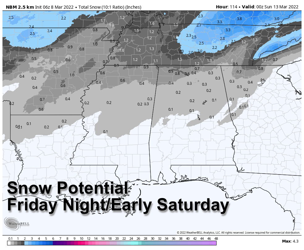
SNOW FLAKES? Once the front passes, much colder air will rush into Alabama Friday night, and there is a chance the rain changes to snow before ending over the northern third of the state (generally from I-20 north). It is the classic situation where cold air is chasing moisture on the back side of a departing storm system, and generally this isn’t a setup for really meaningful accumulation. But, the grass could turn white in a few spots across North Alabama after midnight Friday night into early Saturday morning. Temperatures will drop into the 27-34 degree range early Saturday morning, but for now travel impact isn’t expected.
The sky will clear Saturday, but most communities north of Birmingham won’t get out of the 30s, with a wind chill index close to freezing most of the day.
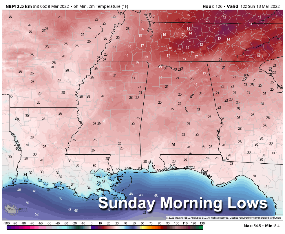
SUNDAY MORNING FREEZE: With a clear sky and light wind, temperatures will drop into the 20-26 degree range for most places early Sunday, and freezing temperatures are likely all the way down to the Gulf Coast. This will be a very significant late season freeze, and growers need to make needed preparations. Sunday will be a sunny day with a high in the 50s.
NEXT WEEK: Global models suggest an upper trough will bring some rain to the state Monday night, otherwise the week looks dry with a warming trend… temperatures reach the 70s over the latter half of the week. See the Weather Xtreme video for maps, graphics, and more details.
ON THIS DATE IN 1909: The town of Brinkley, Arkansas, was struck by an estimated F4 tornado, which killed 49 people. The tornado, which was two-thirds of a mile wide, destroyed 860 buildings. Entire families were killed as houses were completely swept away by the storm.
BEACH FORECAST: Click here to see the AlabamaWx Beach Forecast Center page.
WEATHER BRAINS: Don’t forget you can listen to our weekly 90 minute show anytime on your favorite podcast app. This is the show all about weather featuring many familiar voices, including our meteorologists here at ABC 33/40.
CONNECT: You can find me on all of the major social networks…
Look for the next Weather Xtreme video here by 3:00 this afternoon… enjoy the day!
Category: Alabama's Weather, ALL POSTS, Weather Xtreme Videos
About the Author (Author Profile)
James Spann is one of the most recognized and trusted television meteorologists in the industry. He holds the AMS CCM designation and television seals from the AMS and NWA. He is a past winner of the Broadcast Meteorologist of the Year from both professional organizations.Subscribe
If you enjoyed this article, subscribe to receive more just like it.


