Rain Tonight/Tomorrow Morning; Late Season Freeze This Weekend
RADAR CHECK: Rain is falling across much of East Alabama this afternoon, and more rain is moving into the western counties. Rain will be widespread statewide tonight as a wave of low pressure moves along a stalled front over South Alabama; SPC has defined a “slight risk” (level 2/5) of severe thunderstorms tonight for parts of South Alabama, including Mobile and Baldwin counties, with a “marginal risk” (level 1/5) as far north as Thomasville, Hope Hull, and Troy.
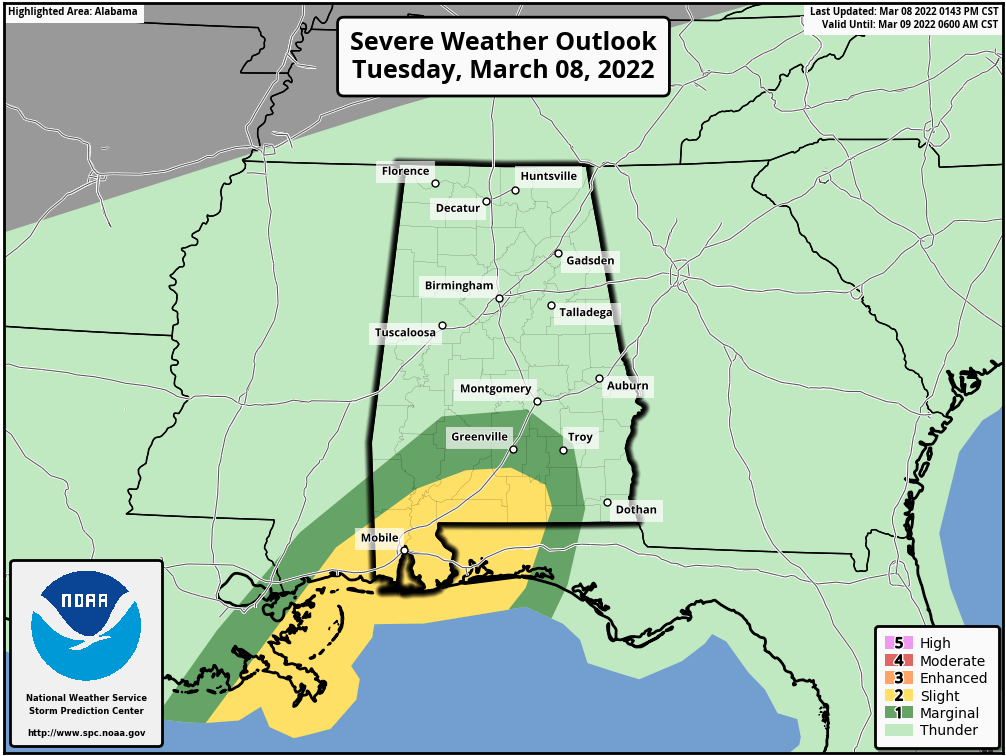
A few storms across far South Alabama tonight could produce strong winds, and an isolated tornado can’t be ruled out. The air is cool and stable over the northern 2/3 of the state and severe storms won’t be an issue there.
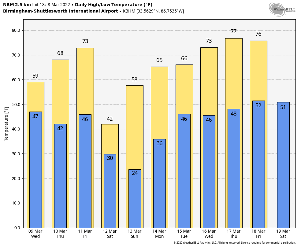
Rain will end tomorrow morning over North/Central Alabama, and by afternoon showers will be confined to the area near the Gulf Coast. Clouds will linger through the day, and the high tomorrow will be in the upper 50s for most places.
Thursday will be a dry day for most of the state with a partly sunny sky, and temperatures warm into the upper 60s by afternoon as a temporary warming trend begins. The high Friday will be close to 70 degrees with clouds increasing during the day.
Rain and storms move into the state late Friday afternoon and early Friday night; SPC has defined a severe weather risk for areas south of a line from near Mobile to Opelika, where unstable air will be in place. For now, severe storms are not expected with the frontal passage over the northern half of the state.
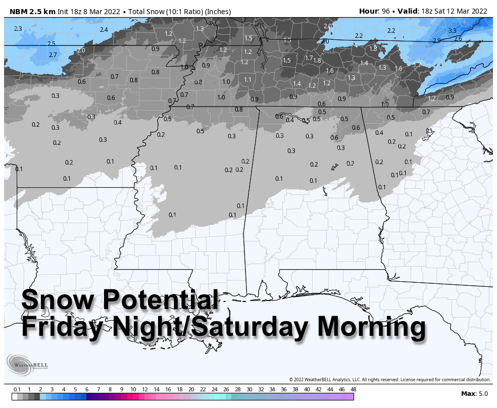
IMPRESSIVE COLD SHOT FOR THE WEEKEND: Much colder air rolls into the state late Friday night following the front, and rain will likely change to snow over the northern third of the state. A few snow flakes could be seen early Saturday morning as far south as Greensboro, Clanton, and Roanoke.
Some light snow accumulation is possible across North Alabama, especially on grassy areas across higher terrain. But, this is a classic case of cold air moving in as deeper moisture moves out, and these type setups rarely produce major snow accumulation here. Temperatures will drop into the 28-34 degree range early Saturday morning, and we will have to watch for isolated slick spots on bridges, but for now major travel impact is not expected.
The sky will clear by Saturday afternoon, but the day will be windy and cold with temperatures holding in the 30s north of Birmingham… the high will be in the 40s over the southern 2/3 of the state. The wind chill index across North Alabama will hover around freezing most of the day.
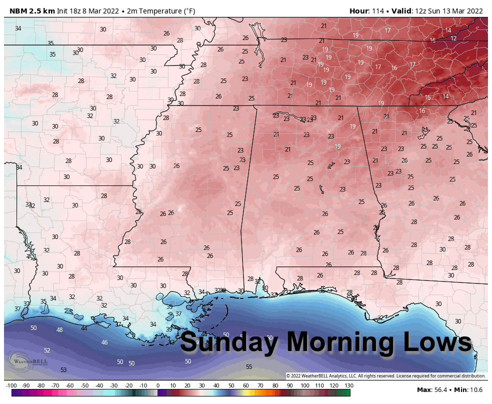
A significant late season freeze is likely early Sunday morning, with lows in the 20-26 degree range for most communities. A freeze is likely all the way down to the Gulf Coast, and a few colder spots could reach the upper teens across North Alabama. Then, during the day Sunday temperatures reach the 50s with a sunny sky.
NEXT WEEK: An upper trough will bring a chance of rain to the state by Monday night and Tuesday… the rest of the week looks dry and warmer with highs returning to the 70s by Wednesday. See the Weather Xtreme video for maps, graphics, and more details.
ON THIS DATE IN 1909: The town of Brinkley, Arkansas, was struck by an estimated F4 tornado, which killed 49 people. The tornado, which was two-thirds of a mile wide, destroyed 860 buildings. Entire families were killed as houses were completely swept away by the storm.
BEACH FORECAST: Click here to see the AlabamaWx Beach Forecast Center page.
WEATHER BRAINS: Don’t forget you can listen to our weekly 90 minute show anytime on your favorite podcast app. This is the show all about weather featuring many familiar voices, including our meteorologists here at ABC 33/40.
CONNECT: You can find me on all of the major social networks…
Look for the next Weather Xtreme video here by 6:00 a.m. tomorrow…
Category: Alabama's Weather, ALL POSTS, Weather Xtreme Videos
About the Author (Author Profile)
James Spann is one of the most recognized and trusted television meteorologists in the industry. He holds the AMS CCM designation and television seals from the AMS and NWA. He is a past winner of the Broadcast Meteorologist of the Year from both professional organizations.Subscribe
If you enjoyed this article, subscribe to receive more just like it.


