Midday Nowcast: Scattered Showers and Some Strong Storms this Afternoon
Scattered showers and storms will remain in the forecast the rest of today as the upper low rotates across the state. At the midday hours, most of the rain/storm activity was stretching from Birmingham down through Montgomery and Troy.
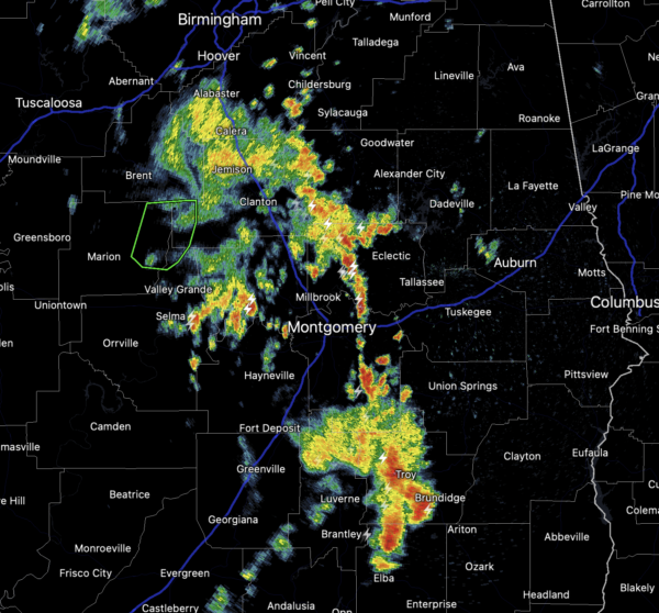
A “marginal risk” for severe storms remains across South/Central Alabama, and this is due to the cold air aloft, which could allow for some storms to produce large hail today.
Also, storms today will produce very heavy rainfall, which could lead to some isolated flash flooding. Highs today will range from the upper 60s to lower 70s.
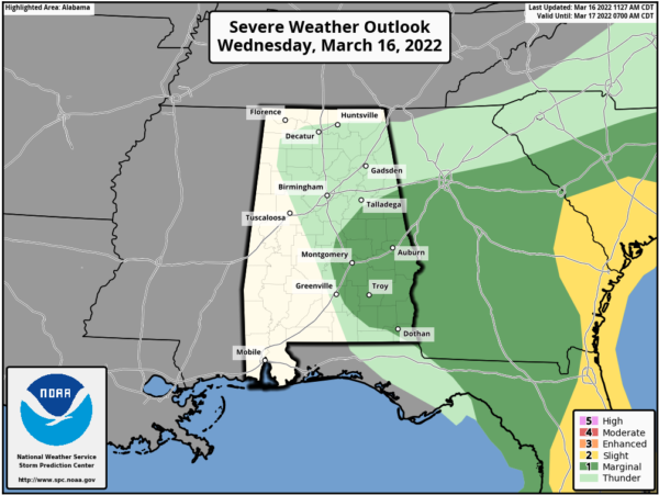
ST. PATRICK’S DAY: Tomorrow looks to be the best day of weather this week with abundant sunshine and highs in the mid 70s. We will be watching developments to our west as our next storm system gets its act together and will produce severe weather west of the state.
FRIDAY FRONT: A cold front will bring showers and thunderstorms back to to Alabama Friday. Some strong thunderstorm are expected and the SPC has all of Alabama in a risk for severe storms, with the level 2 of 5 “slight risk” across southern portions of Alabama.
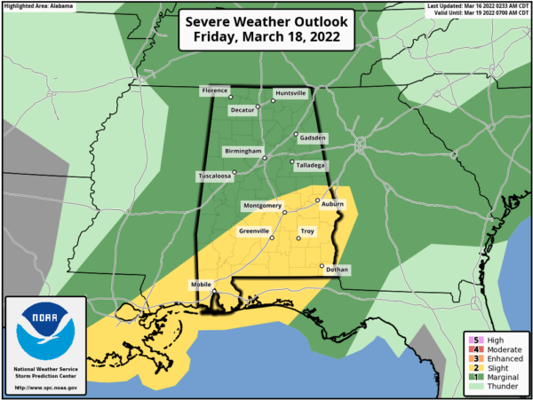
Storms will be capable of producing damaging wind gusts, large hail, and a few tornadoes are possible, especially across the southern half of the state.
WEEKEND WEATHER: Behind the front, a very nice weekend is ahead with sunny mild days and fair cool nights. Highs will be in the mid to upper 60s Saturday, followed by low 70s on Sunday.
NEXT WEEK: Monday will be dry and pleasant, but showers and storms return Tuesday night and into Wednesday; and it looks like we will have to deal with some strong to severe thunderstorms. The SPC has the far western counties of the state in a severe weather risk in their “Day 7” outlook which runs through early Wednesday morning. It is simply too early to know the magnitude, placement, and timing of the event… just something to watch in coming days. The weather will be dry and pleasant Thursday and Friday.
BEACH FORECAST CENTER: Get the latest weather and rip current forecasts for the beaches from Fort Morgan to Panama City on our Beach Forecast Center page. There, you can select the forecast of the region that you are interested in visiting.
WORLD TEMPERATURE EXTREMES: Over the last 24 hours, the highest observation outside the U.S. was 114.4F at Roebourne, Australia. The lowest observation was -77.3F at Vostok, Antarctica.
CONTIGUOUS TEMPERATURE EXTREMES: Over the last 24 hours, the highest observation was 90F at El Centro NAS, CA. The lowest observation was -15F at Seagull Lake, MN.
WEATHER ON THIS DATE IN 1942: Two tornadoes, 24 minutes apart, struck Baldwin, MS, resulting in 65 deaths.
Category: Alabama's Weather, ALL POSTS
About the Author (Author Profile)
Macon, Georgia Television Chief Meteorologist, Birmingham native, and long time Contributor on AlabamaWX. Stormchaser. I did not choose Weather, it chose Me. College Football Fanatic. @Ryan_StinnetSubscribe
If you enjoyed this article, subscribe to receive more just like it.


