Saturday Weather Xtreme — A Quiet Weekend; Severe Storms Looking a Little More Likely on Tuesday & Wednesday
THIS WEEKEND: Other than a few showers moving through the extreme south and southeastern parts of the area this morning, we’ll have some lingering clouds in the northern parts of Central Alabama throughout the daylight hours, while the rest of the area will have a good bit of sunshine. Highs will be in the 60s across the area. Skies will clear out by tonight and lows will drop into the mid 30s to the lower 40s. Sunday will be a brilliant and beautiful day across Central Alabama with mild temperatures. Highs will be in the upper 60s to the lower 70s underneath mainly sunny skies.
A VERY NICE MONDAY: We’ll be in between a high off to our east and a deepening low off to our west that may make it a little breezy at times on Monday. Skies will be mostly sunny, but clouds will increase late as the low gets closer to the deep south. Highs will be in the 70s.
SEVERE THREAT ON TUESDAY THROUGH WEDNESDAY: That low will begin to approach the area on Tuesday bringing with it rain and thunderstorms, and with the setup in place, strong to severe storms will be possible. At 4 pm Tuesday, the storms will be at the state line and will slowly progress eastward to the I-59 corridor by 4 am Wednesday, and in the process of leaving the area by 4 pm Wednesday afternoon. All modes of severe weather will be possible. Highs on Tuesday will be in the lower 70s to the lower 80s, and slightly dropping back into the lower to mid 70s for Wednesday.
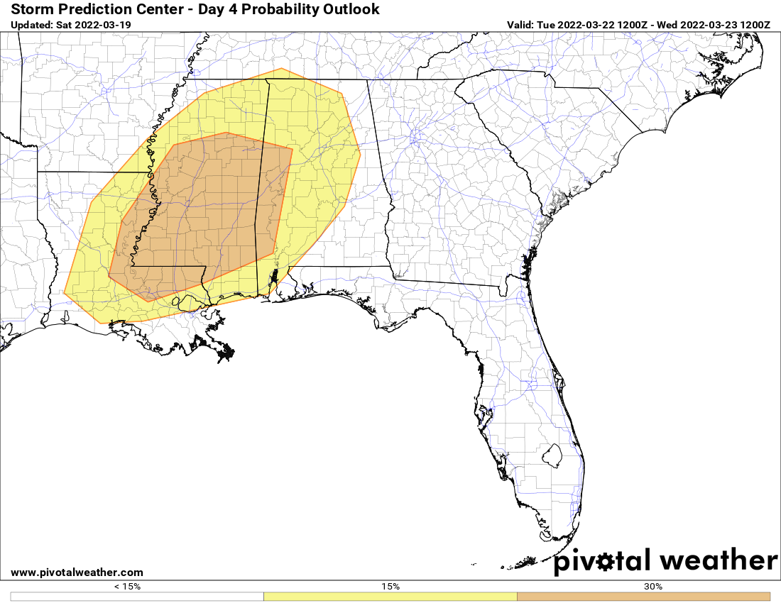
The Storm Prediction Center has much of Central Alabama in a Slight Risk for severe storms on their day four outlooks for Tuesday, with a small portion of the west and the southwest portions of the area in an Enhanced Risk. A Slight Risk is up for the east and southeastern parts of the area on Wednesday.
We’re too far out for the high-resolution models to be in view for this system, so it is still a little too early to pinpoint the magnitude, locations, and timing. Once those start to come in, we’ll get a much better look at what to expect. Just go ahead and refresh those supplies and keep your safe place cleared out.
A QUIET END TO THE WORK WEEK: On Thursday, that system is on by us, and we’ll have a good bit of sunshine for much of the area, but we may have a few light showers over the northern parts of the area during the daylight hours. Highs will be in the lower 60s to the lower 70s. And Friday will be a nice day across the area with mostly sunny skies. Highs will be in the 60s.
Category: Alabama's Weather, ALL POSTS, Severe Weather, Weather Xtreme Videos
About the Author (Author Profile)
Scott Martin is an operational meteorologist, professional graphic artist, musician, husband, and father. Not only is Scott a member of the National Weather Association, but he is also the Central Alabama Chapter of the NWA president. Scott is also the co-founder of Racecast Weather, which provides forecasts for many racing series across the USA. He also supplies forecasts for the BassMaster Elite Series events including the BassMaster Classic.Subscribe
If you enjoyed this article, subscribe to receive more just like it.


