

Active Weather Returns To The State Tomorrow/Wednesday
SUNNY APRIL AFTERNOON: Temperatures are in the 76-82 degree range across Alabama today with a good supply of sunshine. Clouds will move in tonight ahead of a storm system to the west. There will be some risk of strong to severe thunderstorms across the Deep South both tomorrow and Wednesday.
TOMORROW: An organized batch of rain and storms will push through the state tomorrow morning. There is little to no surface based instability over the northern half of the state, so at this point the main threat of severe storms will be over South Alabama. SPC maintains an “enhanced risk” (level 3/5) for areas south of a line from Greensboro to Calera to Wedowee.
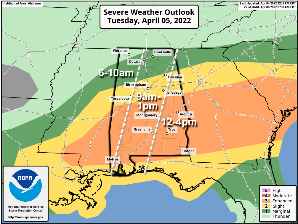
While most of the rain and storms will pass through during the morning hours, storms could linger across Southeast Alabama tomorrow afternoon, where the tornado threat will be maximized. Otherwise, storms across South Alabama tomorrow will be capable of producing hail and strong winds. For North Alabama, rain could be heavy at times, and gusty winds are possible, but with no instability it will be tough for storms to reach severe limits.
The chance of additional storm formation tomorrow afternoon and evening now looks low, although a few isolated showers or storms could be on radar during that time.
WEDNESDAY: A cold front will push a band of storms through Alabama during the afternoon and evening hours. SPC has places like Birmingham, Tuscaloosa, Anniston, Gadsden, Huntsville, and Fort Payne in an “enhanced risk” (level 3/5), while the rest of the state is in a “slight risk” (level 2/5).
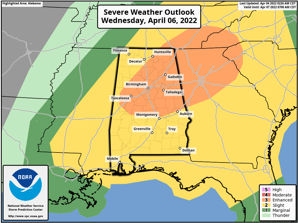
While the deeper moisture will be out of here, instability values will surge Wednesday, reaching the 2000-2500 j/kg range by afternoon. Storms ahead of the cold front will be capable of producing large hail and strong winds. The tornado threat continues to look low due to a unidirectional wind profile, but if a small scale low can form along the front, an isolated tornado can’t be totally ruled out. The storms will sweep through Alabama in the 3:00 p.m. to 9:00 p.m. time frame Wednesday.
Rain amounts of 1-3 inches are likely tomorrow through Wednesday night… some flooding issues could develop.
As always, be sure you can receive severe weather warnings tomorrow and Wednesday, and pay attention to them. And, watch for updates since this is a complex situation. This forecast can change.
LATE SEASON FROST/FREEZE THREAT: The sky becomes partly sunny Thursday, followed by a sunny day Friday. Look for a significant cooling trend; the high Thursday will be in the mid 60s, and then in the 55-62 degree range Friday.
Temperatures will drop into the 30s over the northern half of the state early Saturday and Sunday morning, with potential for frost in many areas, and a freeze for colder spots. For now it looks like the best coverage of frost will be early Sunday when winds will be near calm. Growers will need to watch temperature forecasts closely over the next few days.
Otherwise, the weekend will be sunny with a high in the low 60s Saturday, followed by low 70s Sunday.
NEXT WEEK: Forecast confidence isn’t especially high due to model disagreement; models now suggest there could be some risk of showers Monday and Tuesday, followed by dry and warmer weather over the latter half of the week. See the Weather Xtreme video for maps, graphics, and more details.

ON THIS DATE IN 1977: A violent F5 tornado tore through the northern part of Birmingham, killing 22 people. The tornado began around 3 pm CST, 4 miles northwest of Birmingham near U.S. Highway 78, and then traveled northeast for 15 miles at 60 mph, crossing Interstate 65. At it’s widest point, the tornado was 3/4 of a mile wide. Over 150 homes were damaged with almost 50 destroyed. Daniel Payne College near U.S. Highway 78 sustained heavy damage from this massive tornado with estimates over $1 million dollars. The college, opened in 1880, later closed its doors in 1977, likely a result of the enormous cost and amount of damage.
Timely tornado warnings provided by the National Weather Service allowed people to take necessary action well ahead of the approaching storm. The new NOAA Weather Radio program played a huge role in the process. Warnings were broadcast live on the Birmingham KIH-54 transmitter which was just implemented five months prior to this event.
Many people do not know that the famous Dr. Theodore Fujita, for whom the Tornado Fujita Intensity Scale is named after, followed this massive tornado and supercell thunderstorm from an airplane. After tracking the storm, Dr. Fujita surveyed the damage and toyed with the idea of rating the Smithfield tornado an F6
There were six other tornadoes on this day including five F2 tornadoes and an F3 tornado across North and Central Alabama.
On the same day, Southern Airways Flight 242, flying from Huntsville-Madison County Jetport to Hartsfield Atlanta International Airport, crashed in New Hope, Georgia after suffering hail damage and losing thrust on both engines in a severe thunderstorm. Sixty-three people on the aircraft (including both pilots) and nine people on the ground died; 20 passengers survived, as well as the two flight attendants.
BEACH FORECAST: Click here to see the AlabamaWx Beach Forecast Center page.
WEATHER BRAINS: Don’t forget you can listen to our weekly 90 minute show anytime on your favorite podcast app. This is the show all about weather featuring many familiar voices, including our meteorologists here at ABC 33/40.
CONNECT: You can find me on all of the major social networks…
Look for the next Weather Xtreme video here by 6:00 a.m. tomorrow…
Category: Alabama's Weather, ALL POSTS, Weather Xtreme Videos
About the Author (Author Profile)
James Spann is one of the most recognized and trusted television meteorologists in the industry. He holds the AMS CCM designation and television seals from the AMS and NWA. He is a past winner of the Broadcast Meteorologist of the Year from both professional organizations.Subscribe
If you enjoyed this article, subscribe to receive more just like it.


