Big Warm-Up Later This Week; Dry Through The Weekend
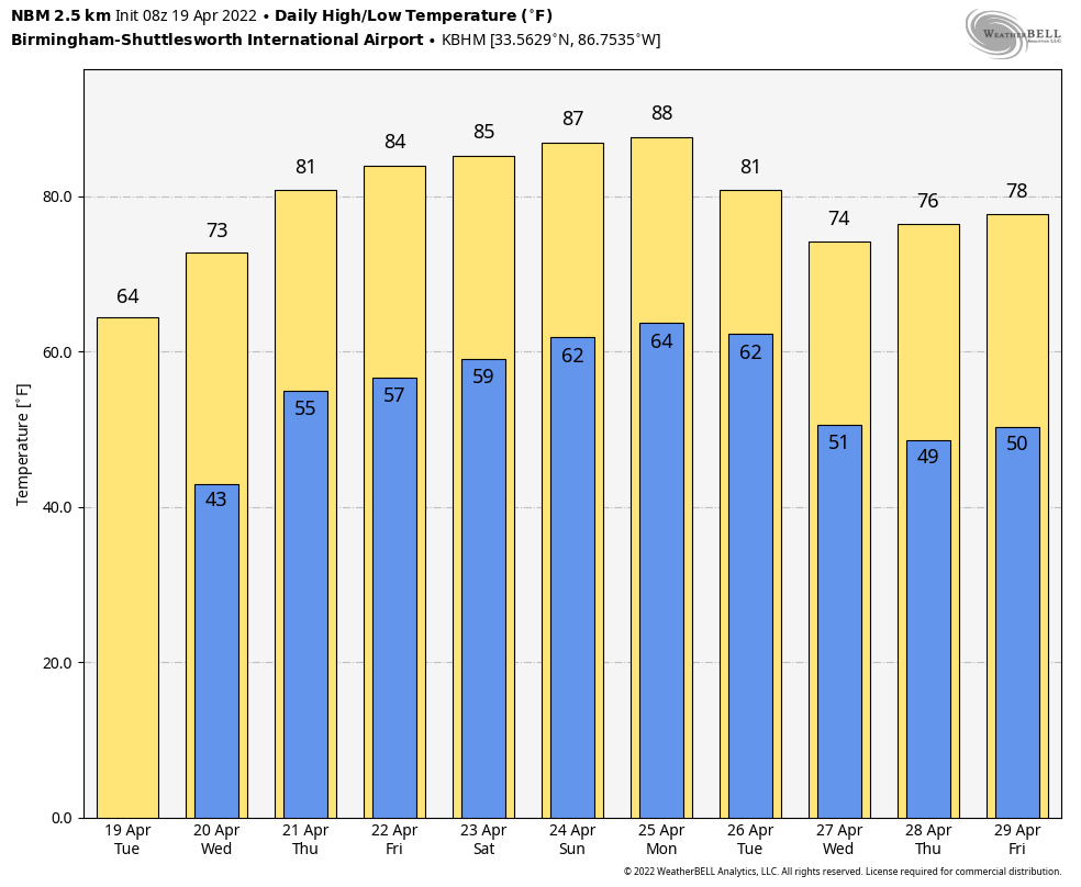
SUNNY DAYS: With a clear sky, temperatures are mostly in the 37-45 degree range across Alabama this morning; we expect a high today in the mid to upper 60s… the average high for Birmingham on April 19 is 76.
The weather will stay dry through the rest of the week with a big warming trend beginning tomorrow afternoon. Look for a high in the mid 70s tomorrow, low 80s Thursday, and mid 80s Friday. Then, we will enjoy the warmest weekend so far this year; the high will be in the 83-88 degree range Saturday and Sunday with a partly to mostly sunny sky. It will feel like summer.
NEXT WEEK: Moisture begins to return Monday and a few widely scattered showers could break out across the state, but the next good chance of showers and storms will come Tuesday as a cold front approaches. For now it doesn’t look like a severe weather setup, and cooler air returns for the latter half of the week with highs back in the 70s. See the Weather Xtreme video for maps, graphics, and more details.
RAIN UPDATE: Here are rain totals since January 1, and the departure from average…
Birmingham 27.76″ (+8.97″)
Huntsville 27.42″ (+9.05″)
Muscle Shoals 24.41″ (+6.86″)
Tuscaloosa 23.36″ (+5.10″)
Anniston 20.71″ (+2.69″)
Montgomery 20.64″ (+3.39″)
Mobile 17.31″ (-1.68″)
Dothan 15.46″ (-1.95″)
ON THIS DATE IN 1986: A major storm system produced ten tornadoes in Texas. One of these tornadoes virtually annihilated the town of Sweetwater. The tornado struck at the unlikely time of 7:17 am. One person was killed, and 100 were injured.
ON THIS DATE IN 2020: A severe thunderstorm developed quickly over Chilton County north of Clanton, with significant straight-line wind developing. Extensive wind damage began in Chilton County (just west of Thorsby and Jemison) where maximum winds were estimated in the range of 80 to 90 MPH. The wind damage continued eastward through Coosa County and Tallapoosa County, where maximum winds were estimated in the range of 70 to 80 MPH. The damage, as confirmed by a NWS survey team, was the result of straight-line wind consisting of numerous snapped and uprooted hardwood/softwood trees, trees falling onto structures, trees falling onto campers, especially notable in Wind Creek State Park where several were crushed, damage to roofs, siding, overhangs, awnings, outbuildings, and a case of wind-driven hail causing severe exterior damage to buildings in the Kellyton area of Coosa County. At least 3 injuries were reported, all in Tallapoosa County.
BEACH FORECAST: Click here to see the AlabamaWx Beach Forecast Center page.
WEATHER BRAINS: Don’t forget you can listen to our weekly 90 minute show anytime on your favorite podcast app. This is the show all about weather featuring many familiar voices, including our meteorologists here at ABC 33/40.
CONNECT: You can find me on all of the major social networks…
Look for the next Weather Xtreme video here by 3:00 this afternoon… enjoy the day!
Category: Alabama's Weather, ALL POSTS, Weather Xtreme Videos
About the Author (Author Profile)
James Spann is one of the most recognized and trusted television meteorologists in the industry. He holds the AMS CCM designation and television seals from the AMS and NWA. He is a past winner of the Broadcast Meteorologist of the Year from both professional organizations.Subscribe
If you enjoyed this article, subscribe to receive more just like it.


