Sunday Weather Video: The Heat Relents a Bit
Strong storms moved across much of North and Central Alabama Saturday afternoon and evening ahead of a cool front that has somehow managed to make its way into South Alabama this morning. High moisture levels and high instability made for some ferocious thunderstorms by late afternoon. Winds gusted to 48 mph at the Gadsden Airport and were estimated to 50-65 mph at some locations. A severe thunderstorm watch was issued and several severe thunderstorm warnings were required, including one for the Birmingham Metro area between 6 and 7 p.m. Rainfall amounts were pretty prodigious, including 1.84” at Birmingham in the three hours leading up to 9 p.m. CDT. Sadly, as is often the case, water rescues had to be employed.
HOTTEST DAT OF YEAR: Saturday saw the highest temperature recorded so far in 2022 at the Birmingham Shuttlesworth International Airport, 100F. It was also the last reading at or above the century mark since October 3, 2019. The heat will back off for the next few days as a pressure weakness and slightly cooler airmass gives a little relief from the heat.
FOR YOUR SUNDAY: Things done feel much different this morning. It is warm and humid with readings in the 70s and dewpoints still in the 70s as well. Skies are mostly cloudy, but the clouds will thin through the day as slightly drier air continues to filter in behind the front. Highs will be in the middle 80s over Central Alabama, where clouds will last longer, and into the lower 90s further to the northwest.
THE WEEK AHEAD: Monday and Tuesday start off the week with just partly cloudy skies across North and Central Alabama with only a few isolated showers and storms. Highs will be about where they should be for this time of year, around 90F.
MIDWEEK DISTURBANCE: This old front, the one that went through over the past 24 hours, will stall with its tail out over the Gulf of Mexico. There are signs that a tropical low could develop along that boundary. Indications have been that it would travel westward, but the latest runs of the GFS indicate that it could meander up into the lower Mississippi Valley and head northeast. High moisture levels will conspire with the disturbance to produce heavy rain and thunderstorms across Alabama. Some of the storms could become severe given a modest amount of wind shear that will be present.
END OF THE WEEK: After the disturbance passes, some drier air will filter back into Alabama by Thursday and Friday. Showers and storms will go back to being more of the random showers and storms during the afternoon and evening hours.
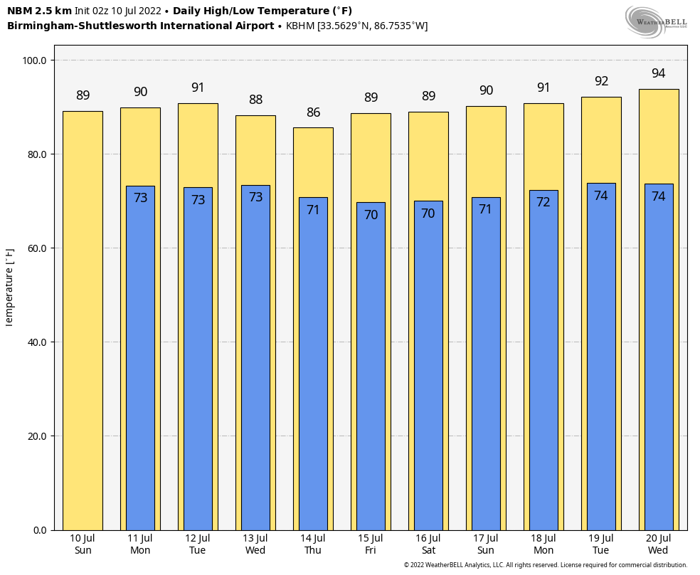
WEEKEND OUTLOOK: Saturday and Sunday will look like fairly typical Alabama summertime weather with hot and humid conditions and daily doses of scattered showers and storms. Stop me if you’ve heard this story…
VOODOO TERRITORY: Fairly typical summertime fare for next weekend across Alabama. Partly cloudy, seasonably hot and humid, with scattered, random, mainly afternoon and evening showers and storms. Highs will be near 90F, with lows in the lower 70s.
BEACHCAST: Looking the data over the next 7 days, rain chances will be high each day. It won’t rain all day, but be prepared for rain each day. Surf will be running 1-3 feet each day with a moderate risk for rip currents. Water temperatures are still pretty comfortable, running in the upper 70s. Air temperatures will be in the middle 80s. Overnight lows will be in the upper 70s.
Click here to see the Beach Forecast Center page.
DANCING WITH THE STATS: Did you see the low temperature record set at Galveston Friday morning? The overnight low only fell to 86F. That established a new record for all of July and came within one degree of tying their all time warm record low of 87F, set on August 31, 2020.
IN THE TROPICS: Things are still quiet across the Atlantic basin, but that will be changing as we move deeper into July and August. More signs this week that the remainder of the season will be hyper-active. The team at Colorado State University is now calling for a total of 20 named storms in the Atlantic, with 10 hurricanes and 5 major hurricanes. We have had three named storms so far and no hurricanes. They are calling for an Accumulated Cyclone Energy total of 180 for the year. All of these predictions are of course well above the long term seasonal averages. The lack of El Nino conditions and the really above normal water temperatures across the main Development Region of the Atlantic is contributing to the higher than average forecast.
ADVERTISE WITH US: Deliver your message to a highly engaged audience by advertising on the AlabamaWX.com website. The site enjoyed over 29 MILLION page views in the past 12 months. Don’t miss out! We can customize a creative, flexible, and affordable package that will suit your organization’s needs. Contact me, Bill Murray, at (205) 687-0782 and let’s talk.
WEATHERBRAINS: This week, the panel will entertain a couple of forensic meteorologists. Learn what they do and how their work can be important in coirt cases. Check out the show at www.WeatherBrains.com. You can also subscribe on iTunes. You can watch the show live at live.bigbrainsmedia.com or on James’ YouTube Channel You will be able to see the show on the James Spann 24×7 weather channel on cable or directly over the air on the dot 2 feed.
ON THIS DATE IN 1913: For years, it was believed that the world’s record highest temperature of 136° occurred at El Azizia, Libya. After a comprehensive review, scientists from the World Meteorological Organization determined that the reading was bogus. This meant that Greenland Ranch in Death Valley, California again holds the record. The mercury reached a blistering 134F on July 10, 1913. Follow my weather history tweets on Twitter. I am @wxhistorian at Twitter.com.
Category: Alabama's Weather, ALL POSTS, Weather Xtreme Videos
About the Author (Author Profile)
Bill Murray is the President of The Weather Factory. He is the site's official weather historian and a weekend forecaster. He also anchors the site's severe weather coverage. Bill Murray is the proud holder of National Weather Association Digital Seal #0001 @wxhistorianSubscribe
If you enjoyed this article, subscribe to receive more just like it.


