Midday Nowcast: Sun and Clouds; Watching the Northern Gulf
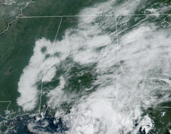
We are seeing a mix of sun and clouds with most of Central and North Alabama remaining dry, even though a few pop-up afternoon showers are possible. However, this is not the case to the south, as deep moisture levels are in place across the southern half of Alabama as a trough in the Gulf is producing numerous showers ands storms. Most of this activity will remain over southern portions of the state today, but should begin to head north tomorrow. Temperature this afternoon are in the upper 80s and low 90s.
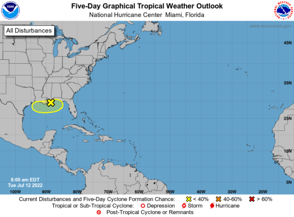
IN THE GULF: Disorganized showers and thunderstorms over the northern Gulf of Mexico are associated with a trough of low pressure. This system is expected to meander near the northern Gulf coast the next fews days, and gradual development is possible if it remains offshore. Regardless of development, heavy rains will pose a risk of flash flooding along portions of the northern Gulf coast from Louisiana to the Florida Panhandle over the next several days. Formation chance through 5 days…low…30 percent. The feature looks to move onshore before it really gets organized so we are not expecting it to develop, but if it were too, it would be Danielle.
If you have a trip planned to the Central Gulf Coast (Dauphin Island to Gulf Shores to Panama City Beach), it won’t rain all day every day, but it will be wet and stormy at times, with some intervals of sun. Also, rip currents are high right now, please pay attention to the flag warning systems along the beaches.
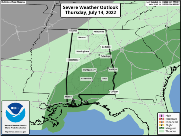
WEDNESDAY THROUGH FRIDAY: As the tropical feature moves closer to the coast the next 48 hours it will cause moisture levels to surge north in the coming days. For North/Central Alabama we will see more clouds than sun with occasional showers and storms. High temperatures should hold in the 80s for most locations. The more widespread rain and storms should remain over the southern half of the state where some locations could receive several inches of rain, and may have to deal with some strong storms tomorrow and again on Thursday.
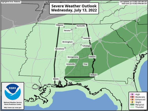
We note the SPC has defined a “marginal risk” (level 1/5) for parts of Central Alabama Wednesday and again on Thursday as a few storms could produce strong winds.
By late Friday, this feature should be moving east of us, allowing drier air to sneak back into the state from the north.
THE ALABAMA WEEKEND: Pretty routine summer weather with partly sunny days, fair nights, and a few showers and storms around during the afternoon and evening hours. Afternoon highs not too far from 90 degrees as the core of the heat across the nation remains west of Alabama.
NEXT WEEK: The upper high will begin to nose in here, meaning slightly higher heat levels with highs in the 90-95 degree range most days. And, the usual risk of scattered, mostly afternoon and evening showers and thunderstorms on a daily basis.
BEACH FORECAST CENTER: Get the latest weather and rip current forecasts for the beaches from Fort Morgan to Panama City on our Beach Forecast Center page. There, you can select the forecast of the region that you are interested in visiting.
WORLD TEMPERATURE EXTREMES: Over the last 24 hours, the highest observation outside the U.S. was 117.3F at Basrah-Hussen, Iraq. The lowest observation was -92.6F at Dome A, Antarctica.
CONTIGUOUS TEMPERATURE EXTREMES: Over the last 24 hours, the highest observation was 122F at Death Valley, CA. The lowest observation was 27F at Peter Sinks, UT.
Category: Alabama's Weather, ALL POSTS
About the Author (Author Profile)
Macon, Georgia Television Chief Meteorologist, Birmingham native, and long time Contributor on AlabamaWX. Stormchaser. I did not choose Weather, it chose Me. College Football Fanatic. @Ryan_StinnetSubscribe
If you enjoyed this article, subscribe to receive more just like it.


