Dry Air Moves Into North Alabama Today
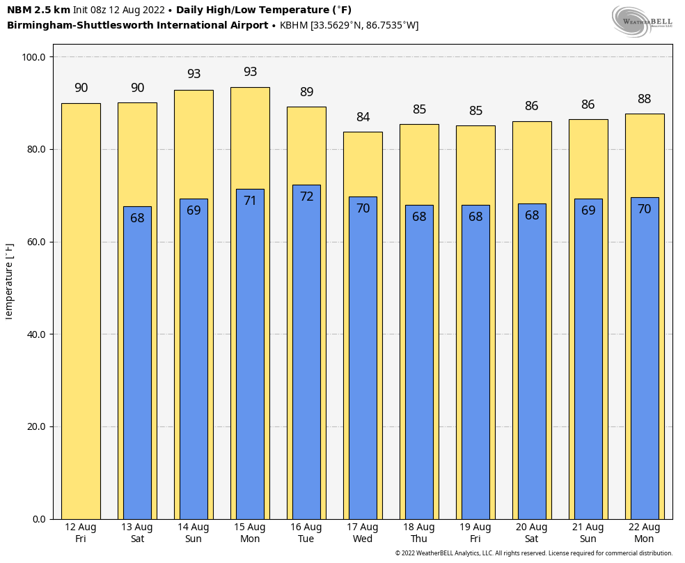
RADAR CHECK: Showers and storms are confined to the immediate Gulf Coast early this morning; the rest of the state is dry with temperatures in the 70s. A drier airmass will drop into North Alabama today; most of the scattered showers and storms will be over the southern counties this afternoon. Otherwise, look for a partly sunny sky today with a high between 87 and 91 degrees.
THE ALABAMA WEEKEND: Look for mostly sunny days, fair nights, and slightly lower humidity levels for most of Alabama; showers will be found mainly over the far southern part of the state and near the Gulf Coast. Lows will be in the 60s… parts of North Alabama will drip into the low 60s early tomorrow morning for a touch of fall.
NEXT WEEK: Monday looks mostly dry, with just a few scattered showers over South Alabama. Then, moisture levels rise statewide, and we will mention scattered showers and storms Tuesday and Wednesday. Showers thin out a bit Thursday and Friday; highs through the week will be in the 87-92 degree range. See the daily Weather Briefing video for maps, graphics, and more details.
TROPICS: All remains amazingly quiet across the Atlantic basin for mid-August, and tropical storm formation is not expected through at least the next five days.
ON THIS DATE IN 1955: Connie made landfall on the North Carolina coast as a Category 3 hurricane. Ahead of the storm, about 2000 people were evacuated from flood-prone areas in New Bern and up to 14,000 people were evacuated along the North Carolina beaches. As the storm reached landfall near Fort Macon, sustained winds of 75 mph with gusts to 100 mph were observed, while a storm surge of up to 8 ft occurred along the coast.
In Connecticut, rain from Connie, and later in the month from Hurricane Diana, which followed a similar path, set up severe flooding during August 1955. The amount of rain that fell in August 1955 in Connecticut is so off the charts no event has come anywhere close to it in the last 100 years. That year’s monthly record of 21.87? at Bradley Airport stands alone as the wettest month on record – the second highest 16.32? from October 2005 lags far behind.
ON THIS DATE IN 2005: A tornado strikes Wright, Wyoming, a coal-mining community, killing two and destroying 91 homes and damaging about 30 more in around the town.
BEACH FORECAST: Click here to see the AlabamaWx Beach Forecast Center page.
Look for the next Weather Xtreme Video here by 3:00 this afternoon… enjoy the day!
Category: Alabama's Weather, ALL POSTS, Weather Xtreme Videos
About the Author (Author Profile)
James Spann is one of the most recognized and trusted television meteorologists in the industry. He holds the AMS CCM designation and television seals from the AMS and NWA. He is a past winner of the Broadcast Meteorologist of the Year from both professional organizations.Subscribe
If you enjoyed this article, subscribe to receive more just like it.


