Strong Storms Over Southwest Alabama; Scattered Rain Near The Tennessee State Line
RADAR CHECK: As expected, the stronger thunderstorms across Alabama today are over the southwest corner of the state, where parts of Mobile and Baldwin counties are under a severe thunderstorm warning as I write this at mid-afternoon. These storms are south of a surface front; north of that boundary the sky is partly to mostly sunny over the central counties of the state. And, up in the Tennessee Valley of far North Alabama, some light to moderate rain is falling ahead of a disturbance north of the state. Temperatures range from the upper 70s at Huntsville to the mid 90s over South Alabama.
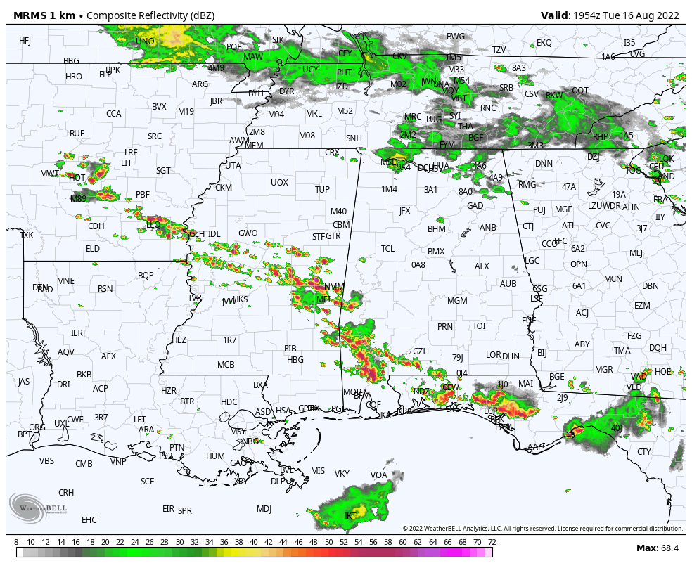
Showers and storms across the state will fade later tonight after sunset.
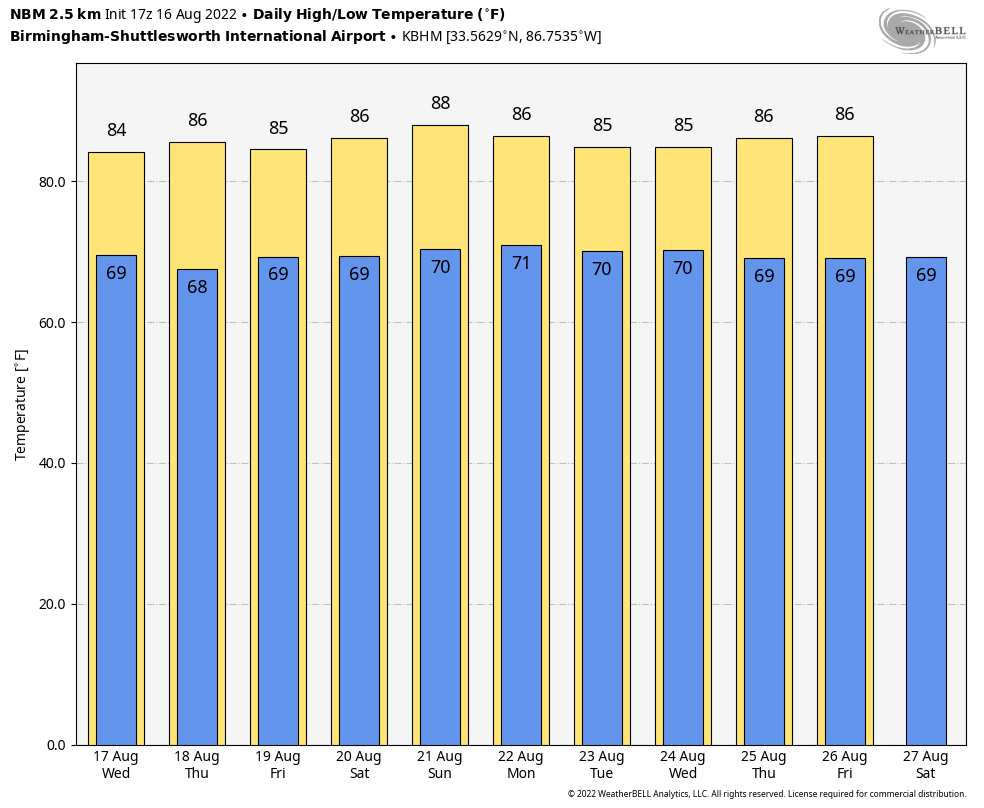
TOMORROW/THURSDAY: The surface boundary will dissipate, and moisture levels will slowly rise statewide. We expect a mix of sun and clouds both days with scattered showers and storms around, most active during the afternoon and evening hours. Highs will be in the 85-89 degree range for most communities.
FRIDAY AND THE WEEKEND: High precipitable water values will be in place, and we expect scattered to numerous showers and thunderstorms on these three days. Not a total “wash-out” at all, but a passing shower or storm is a good possibility from time to time. Most of the showers, but not necessarily all of them, will come from noon to midnight. The sky will be occasionally cloudy with highs mostly in the mid 80s, which is below average for mid-August in Alabama.
NEXT WEEK: A number of showers and storms are likely Monday and Tuesday; they should thin out a bit over the latter half of the week. Afternoon highs remain in the 80s… See the daily Weather Briefing video for maps, graphics, and more details.
FOOTBALL WEATHER: The high school football season kicks off Friday night for most schools; the weather will be warm and humid, and random storms will be around during the evening hours. No way of knowing in advance the exact locations, but a few games could experience a lighting delay. Temperatures will be in the low to mid 80s at kickoff, falling into the upper 70s by the second half.
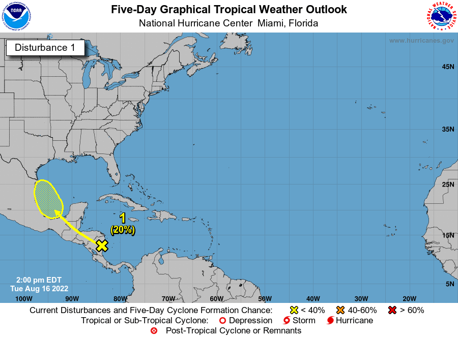
TROPICS: A tropical wave currently located over Nicaragua is forecast to move across Central America during the next few days and emerge over the Bay of Campeche, where an area of low pressure could form on Friday. Some gradual development of this system is possible while it moves northwestward over the southwestern Gulf of Mexico through the weekend. For now NHC gives this disturbance a 20 percent chance of development over the next five days… the rest of the Atlantic basin is very quiet.
ON THIS DATE IN 1992: A tropical wave in the Atlantic grew into a tropical depression; the next day it would become Tropical Storm Andrew. Further development was slow, as the west-northwestward moving Andrew encountered an unfavorable upper-level trough. Indeed, the storm almost dissipated on August 20 due to vertical wind shear. By August 21, Andrew was midway between Bermuda and Puerto Rico and turning westward into a more favorable environment. Rapid strengthening occurred, with Andrew reaching hurricane strength on the 22nd and Category 4 status on the 23rd. It would go on to be one of the most destructive hurricanes on record in the U.S… striking South Florida August 24, and Louisiana August August 26.
BEACH FORECAST: Click here to see the AlabamaWx Beach Forecast Center page.
Look for the next Weather Xtreme video here by 6:00 a.m. tomorrow…
Category: Alabama's Weather, ALL POSTS, Weather Xtreme Videos
About the Author (Author Profile)
James Spann is one of the most recognized and trusted television meteorologists in the industry. He holds the AMS CCM designation and television seals from the AMS and NWA. He is a past winner of the Broadcast Meteorologist of the Year from both professional organizations.Subscribe
If you enjoyed this article, subscribe to receive more just like it.


