Long Dry Spell Ahead For Alabama
COOL MORNING: Here are some temperatures just before sunrise across Alabama…
Oneonta 48
Cullman 50
Remlap 50
Heflin 50
Gadsden 51
Pell City 52
Anniston 53
Decatur 53
Good Hope 53
Huntsville 54
Muscle Shoals 54
Bessemer 54
Birmingham 55
Tuscaloosa 58
Montgomery 62
Mobile 67
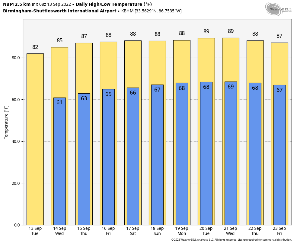
A very dry airmass now covers Alabama, and we are forecasting sunny warm days and clear pleasant nights through Friday. The high today will be in the low 80s, followed by mid 80s tomorrow. Heat levels inch up a bit Thursday and Friday with highs in the 84-87 degree range… but humidity levels will remain relatively low.
THE WEEKEND AND NEXT WEEK: The dry pattern will persist for much of the state. The weekend will be warm and dry with highs in the 80s, and most of next week will remain rain-free as well. For those of you involved with agriculture or contraction that need a good, long dry spell, this is your chance. Highs next week will be in the upper 80s on most days, a little above average for mid-September in Alabama. See the daily Weather Briefing video for maps, graphics, and more details.
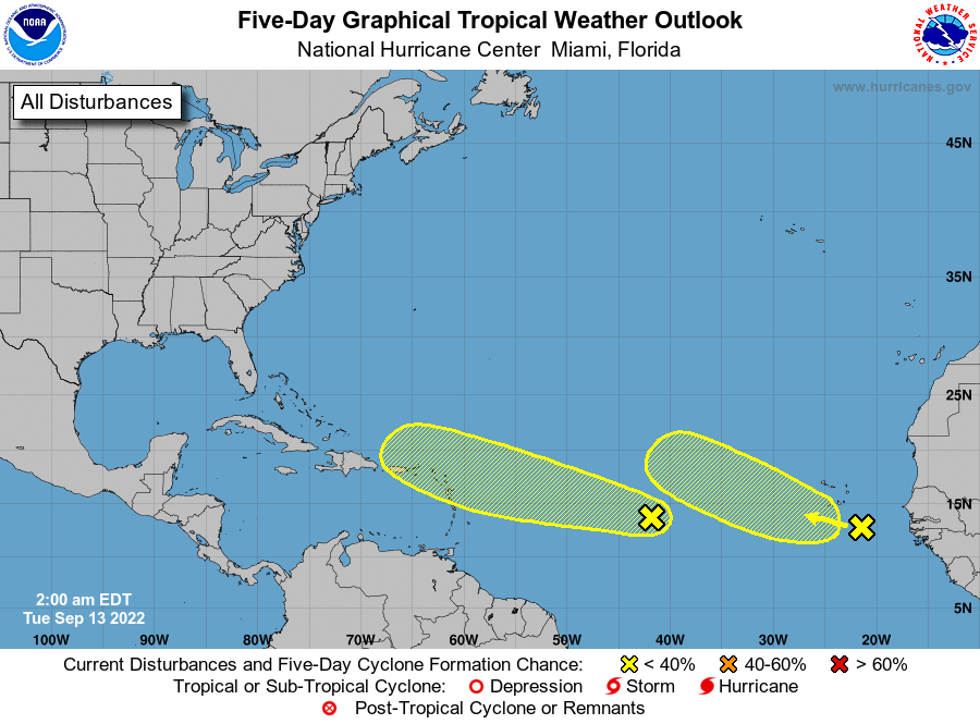
TROPICS: NHC continue to monitor two tropical waves in the Atlantic, both with a low chance of development over the next five days. The lead wave in the Central Atlantic could see a higher chance of development in 5-8 days as it will be near the Leeward Islands and Puerto Rico then; too early to know if it will be an issue for the U.S. coastline, but global models suggest a northward turn before reaching North America.
ON THIS DATE IN 1988: Hurricane Gilbert smashed into the Cayman Islands, and as it headed for the Yucatan Peninsula of Mexico it strengthened into a monster hurricane, packing winds of 175 mph. The barometric pressure at the center of Gilbert reached 888 mb, a record for any hurricane in the Caribbean, Gulf of Mexico, or the Atlantic Ocean until Hurricane Wilma in 2005. Gilbert covered much of the Gulf of Mexico, producing rain as far away as the Florida Keys.
ON THIS DATE IN 2008: Hurricane Ike made landfall as a Category 2 storm near Galveston. Due to its immense size, Ike caused devastation from the Louisiana coastline all the way to the Kenedy County region near Corpus Christi.
BEACH FORECAST: Click here to see the AlabamaWx Beach Forecast Center page.
Look for the next Weather Briefing video here by 3:00 this afternoon… enjoy the day!
Category: Alabama's Weather, ALL POSTS, Weather Xtreme Videos
About the Author (Author Profile)
James Spann is one of the most recognized and trusted television meteorologists in the industry. He holds the AMS CCM designation and television seals from the AMS and NWA. He is a past winner of the Broadcast Meteorologist of the Year from both professional organizations.Subscribe
If you enjoyed this article, subscribe to receive more just like it.


