Heat Levels Rising Through Mid-Week; Cooler By Friday
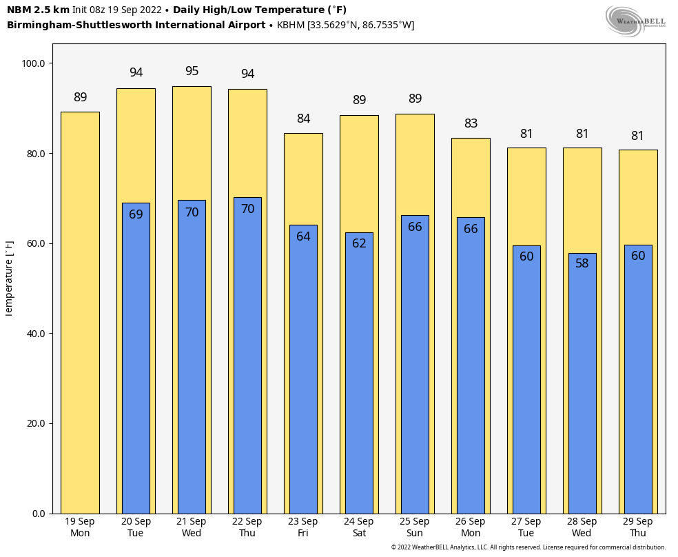
STILL DRY: Today will be the ninth consecutive day with no measurable rain for most of Alabama; the sky will be mostly sunny with a high in the 87-90 degree range this afternoon. Heat levels will continue to rise through mid-week as a large scale upper high moves across the region; we project highs in the mid 90s tomorrow and Wednesday. Here are the record highs for Birmingham on those two days…
Tomorrow 100 (1925)
Wednesday 98 (2010)
We won’t top those levels, but temperatures will be about ten degrees above average for late September.
THURSDAY THROUGH THE WEEKEND: A dry cold front will pass through the state Thursday; the day will be partly to mostly sunny with a high in the low 90s. Then, Friday will be noticeably cooler with a high in the low 80s. Many places over North Alabama will see lows in the 50s early Friday and Saturday morning as the “fall feel” returns. Saturday will be a sunny day with a high in the mid 80s.
The day Sunday looks dry with a high in the 80s, but we will bring in a chance of showers Sunday night ahead of another cold front. Rain amounts should be light, generally under 1/4 inch.
NEXT WEEK: Showers end early Monday; the temperatures will hold in the 70s much of the day. Then, the rest of the week looks generally dry with highs in the low to mid 80s, close to average values. See the daily Weather Briefing video for maps, graphics, and more details.
TROPICS: Hurricane Fiona early this morning, with winds of 90 mph, is located near Punta Cana in the Dominican Republic. Heavy rains from outer bands of Fiona will continue across Puerto Rico into this afternoon. The center of Fiona will persist over eastern Dominican Republic into this afternoon with heavy bands there lasting through tonight. These rainfall amounts will continue to produce life-threatening and catastrophic flooding along with mudslides and landslides across Puerto Rico. Life-threatening flash and urban flooding is likely for eastern portions of the Dominican Republic.
Fiona is forecast to strengthen after moving away from Puerto Rico and the Dominican Republic. Hurricane conditions are expected in the Turks and Caicos tomorrow, and tropical storm conditions are expected in the southeastern Bahamas by late tonight or early tomorrow. From there the hurricane moves northeast, and it will be close to Bermuda late Thursday night.
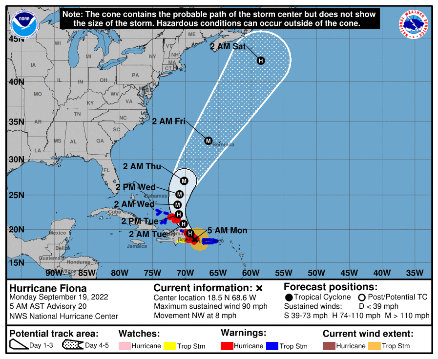
The rest of the Atlantic basin is quiet, and no tropical storms or hurricanes will threaten the Gulf of Mexico for at least the next seven days.
ON THIS DATE IN 1947: A hurricane made landfall near the Chandeleur Islands, LA on this day. Wind gusts of 112 mph and a central pressure of 967 mb were measured at Moisant International Airport. A storm surge of 9.8 feet reached Shell Beach, Lake Borgne. Moisant Airport field was flooded by two ft. of water while Jefferson Parish was flooded to depths of 3.28 ft. New Orleans suffered $100 million in damages. Total loss of life was 51 people. As a result of this storm, hurricane protection levees were built along the south shore of Lake Pontchartrain to protect Orleans and Jefferson Parishes from future storm surges.
BEACH FORECAST: Click here to see the AlabamaWx Beach Forecast Center page.
Look for the next Weather Xtreme video here by 3:00 this afternoon… enjoy the day!
Category: Alabama's Weather, ALL POSTS, Weather Xtreme Videos
About the Author (Author Profile)
James Spann is one of the most recognized and trusted television meteorologists in the industry. He holds the AMS CCM designation and television seals from the AMS and NWA. He is a past winner of the Broadcast Meteorologist of the Year from both professional organizations.Subscribe
If you enjoyed this article, subscribe to receive more just like it.


