Cooler Air Arrives Tonight; Watching The Tropics
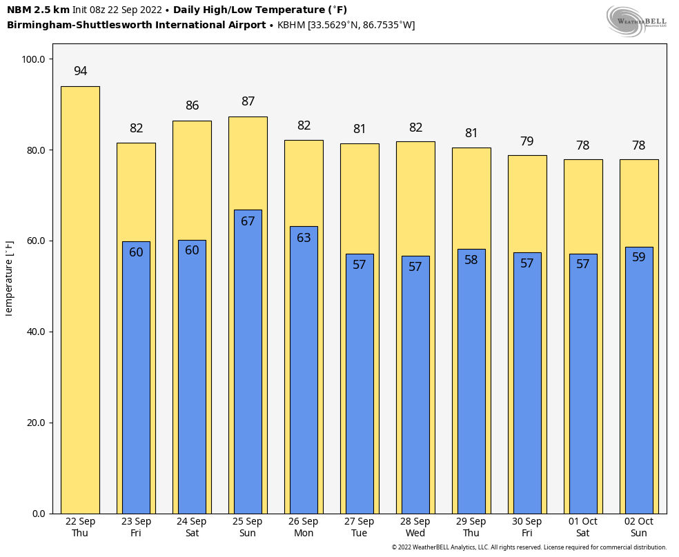
ONE MORE HOT DAY: Temperatures rise into the 90-94 degree range across Alabama this afternoon with a partly to mostly sunny sky, but it will be our last really hot, summer-like day for a while thanks to a cold front that will pass through the state in dry fashion tonight. The high tomorrow will be near or just over 80 degrees with lower humidity, and by early Saturday morning most North Alabama communities will be in the 50s as the “fall feel” returns.
Saturday will be a sunny, warm day as the weekend begins with a high in the mid 80s. Then, on Sunday, we will mention a chance of showers for the northern half of the state ahead of the next cold front. Moisture will be limited, and rain amounts will be light (generally under 1/4 inch for most places). The high Sunday will be in the low 80s with a mix of sun and clouds.
NEXT WEEK: For now most of the week looks dry with very pleasant temperatures. Highs in the 77-82 degree range, with lows in the 50s. See the daily Weather Briefing video for maps, graphics, and more details.
FOOTBALL WEATHER: Perfect weather for the high school games across the state tomorrow night; clear and very pleasant with temperatures falling into the 60s.
Saturday, Auburn hosts Missouri at Jordan-Hare Stadium (11a CT kickoff)… the sky will be sunny with temperatures rising from near 77 and kickoff, into the low 80s by the second half.
Alabama will host Vanderbilt at Bryant Denny Stadium Saturday evening (6:30p CT kickoff)… the sky will be clear with temperatures falling from 80 degrees at kickoff, into the low 70s by the final whistle.
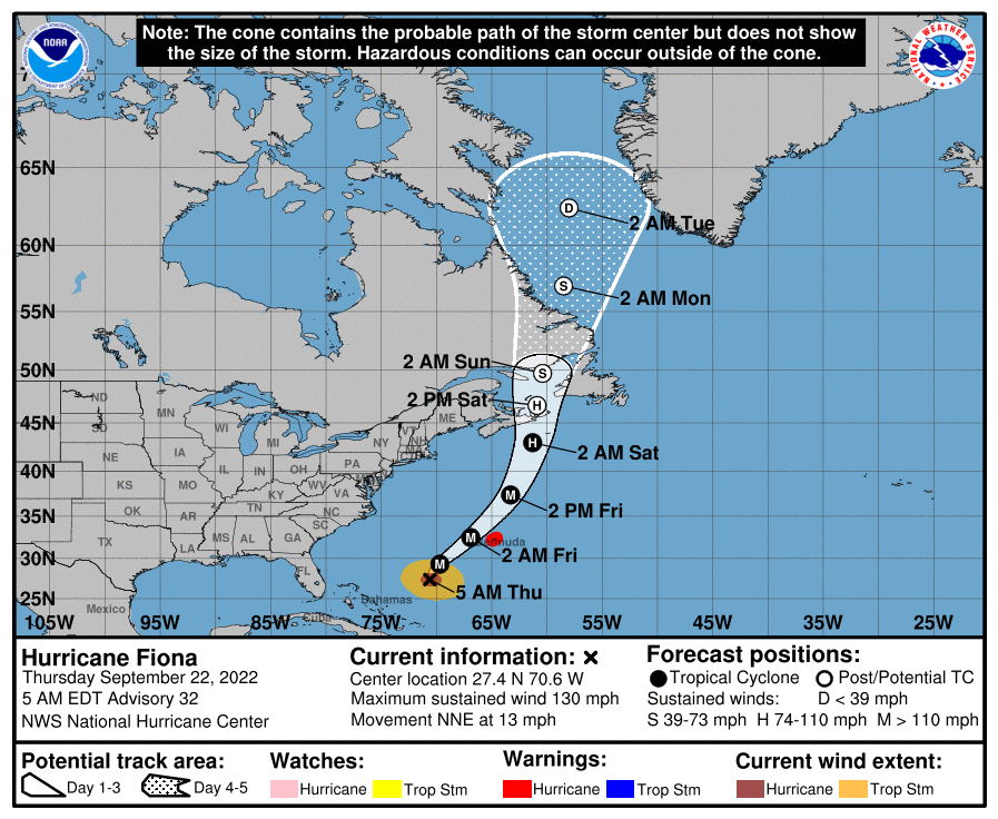
TROPICS: Hurricane Fiona, with winds of 130 mph, will pass a little west of Bermuda late tonight and early tomorrow morning; a hurricane warning has been issued for Bermuda.
Tropical Storm Gaston in the higher latitudes of the Atlantic will remain far from land, with the exception of the Azores.
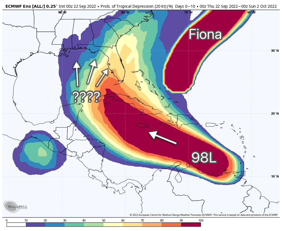
Most of the attention remain focused on a tropical wave in the far southern Caribbean, Invest 98L. It remains disorganized early this morning, Although upper-level winds are currently inhibiting development, the upper-level wind pattern ahead of the system is forecast to become a little more favorable in a couple of days, and a tropical depression is likely to form at that time. The disturbance is forecast to move west-northwestward across the eastern Caribbean Sea during the next day or two, and be over the central Caribbean Sea this weekend.
There is a reasonable chance this will be Hurricane Hermine early next week as it moves into the southern Gulf of Mexico. It remains too early to know the final destination or intensity; no skill in a tropical cyclone forecast more than seven days in advance. Any Gulf Coast impact will be toward the end of next week, and for now using global model ensemble guidance the higher probabilities of impact are over the eastern half of the Gulf Coast and around the Florida Peninsula.
If you live on the coast, there is no need to be anxious, but simply be prepared and watch for updates. Once a low level center is established over the next day or so, we will have a much better idea of the track.
ON THIS DATE IN 2006: The tristate area of Missouri, Illinois, and Kentucky was struck by the worst tornado outbreak in the recorded history during the month of September. One supercell produced a long-track F4 tornado across southeastern Missouri into southwestern Illinois. This tornado traveled 27.5 miles.
BEACH FORECAST: Click here to see the AlabamaWx Beach Forecast Center page.
Look for the next Weather Xtreme video here by 3:00 this afternoon… enjoy the day!
Category: Alabama's Weather, ALL POSTS, Weather Xtreme Videos
About the Author (Author Profile)
James Spann is one of the most recognized and trusted television meteorologists in the industry. He holds the AMS CCM designation and television seals from the AMS and NWA. He is a past winner of the Broadcast Meteorologist of the Year from both professional organizations.Subscribe
If you enjoyed this article, subscribe to receive more just like it.


