Midday Nowcast: Front Dropping South; Julia Forms in Caribbean
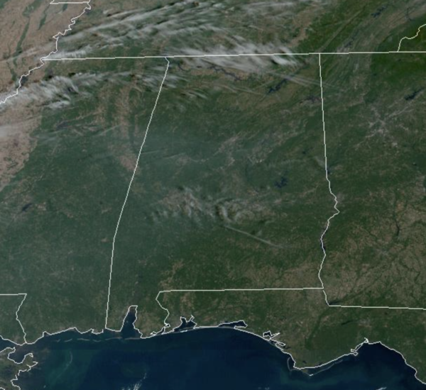
WARM, FALL FRIDAY: Plenty of sunshine again today and temperatures this afternoon are surging into the low and mid 80s. The cold front is dropping south through the state this afternoon and evening. It is coming through in dry fashion, no rain, but there are a few more clouds in the Alabama sky today.
FRIDAY NIGHT LIGHTS: Another delightful evening for high school football games across the state Friday night; expect passing clouds with temperatures falling through the 60s.
WEEKEND WEATHER: The cooler air arrives tomorrow as our highs drop into the low 70s with a brisk north wind at times. Sunday morning will be our coolest morning so far this season with lows well down in the 40s…and cooler spots could visit the 30s. Sunday will be sunny and gorgeous with highs staying in the 70s.
FOOTBALL WEATHER: Auburn travels to Athens tomorrow take on the Georgia bulldogs (2:30p CT kickoff)… the sky will be sunny; about 75° at kickoff, falling to near 70° by the final whistle.
UAB has a home game in downtown Birmingham Saturday at Protective Stadium against Middle Tennessee (also a 2:30p CT kickoff)… it will be sunny afternoon with temperatures falling from around 73° at kickoff into the upper 60s by the final whistle.
Tomorrow night Alabama hosts Texas A&M (7p CT kickoff) at Bryant-Denny Stadium in Tuscaloosa; the sky will be clear with temperatures falling from 65° at kickoff into the 50s by the fourth quarter. A perfect night for football
IN THE TROPICS: Tropical Depression Twelve has become a remnant low in the Atlantic and is no more. Tropical Depression Thirteen is now Julia. The center of Tropical Storm Julia was located near latitude 12.7 North, longitude 73.1 West. Julia is moving toward the west near 18 mph. A westward motion with some decrease in forward speed is expected through Sunday. On the forecast track, the center of Julia is expected to move across the southwestern Caribbean Sea during the next couple of days, passing near San Andres and Providencia Islands Saturday evening, and reaching the coast of Nicaragua Sunday morning. After landfall, Julia or its remnants are expected to turn west-northwestward and move across Central America through Monday.
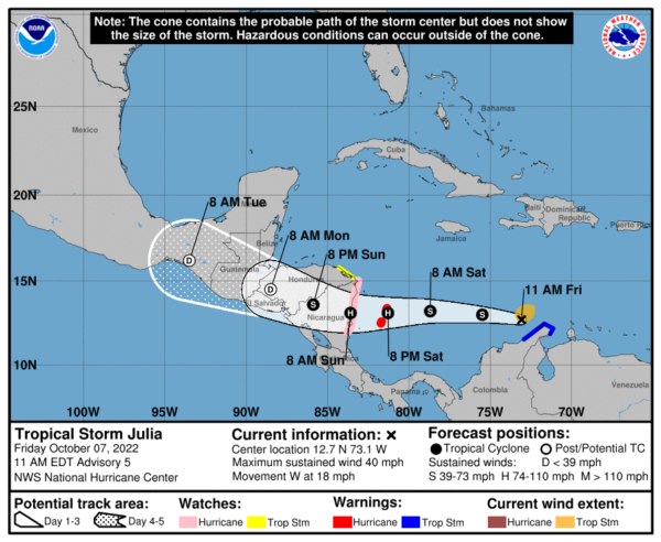
Data from an Air Force Reserve Hurricane Hunter aircraft indicate that maximum sustained winds have increased to near 40 mph with higher gusts. Additional strengthening is forecast, and Julia is expected to become a hurricane by Saturday evening before it reaches San Andres and Providencia Islands, and the coast of Nicaragua. Tropical-storm-force winds extend outward up to 80 miles from the center. The minimum central pressure is 1002 mb (29.59 inches) based on data from the reconnaissance aircraft.
NEXT WEEK: Not much change Monday through Wednesday; we expect a warming trend with highs exceeding 80 degrees again by mid-week. Then, a cold front will approach Thursday, which will bring our first chance of rain in quite a while. We aren’t expecting a big rain event, but periods of rain are likely Thursday with amounts generally 1/4 inch or less. Then, Friday will be sunny and cooler with a high in the low 70s.
BEACH FORECAST CENTER: Get the latest weather and rip current forecasts for the beaches from Fort Morgan to Panama City on our Beach Forecast Center page. There, you can select the forecast of the region that you are interested in visiting.
WORLD TEMPERATURE EXTREMES: Over the last 24 hours, the highest observation outside the U.S. was 112.3F at Badrah, Iraq. The lowest observation was -81.2F at Dome A, Antarctica.
CONTIGUOUS TEMPERATURE EXTREMES: Over the last 24 hours, the highest observation was 107F at Death Valley, CA. The lowest observation was 12F at Hazen, ND.
Category: Alabama's Weather, ALL POSTS
About the Author (Author Profile)
Macon, Georgia Television Chief Meteorologist, Birmingham native, and long time Contributor on AlabamaWX. Stormchaser. I did not choose Weather, it chose Me. College Football Fanatic. @Ryan_StinnetSubscribe
If you enjoyed this article, subscribe to receive more just like it.


