TS-13 Strengthens Into Tropical Storm Julia; No Threat to US
TROPICAL STORM JULIA FORMS OFF THE GUAJIRA PENINSULA… HURRICANE WATCHES AND WARNINGS ISSUED FOR NICARAGUA AND THE OFFSHORE COLOMBIAN ISLANDS.
SUMMARY OF 1100 AM EDT…1500 UTC…INFORMATION
———————————————–
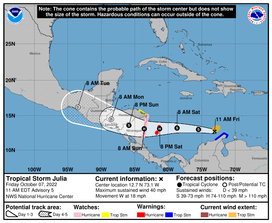
LOCATION…12.7N 73.1W
ABOUT 110 MI…175 KM W OF NTHRN TIP OF GUAJIRA PNSULA, COLOMBIA
ABOUT 560 MI…900 KM E OF ISLA DE PROVIDENCIA, COLOMBIA
MAXIMUM SUSTAINED WINDS…40 MPH…65 KM/H
PRESENT MOVEMENT…W OR 280 DEGREES AT 18 MPH…30 KM/H
MINIMUM CENTRAL PRESSURE…1002 MB…29.59 INCHES
WATCHES AND WARNINGS
——————–
A Hurricane Warning is in effect for…
* San Andres, Providencia, and Santa Catalina Islands in Colombia
A Hurricane Watch is in effect for…
* Nicaragua from Bluefields to the Nicaragua/Honduras border
A Tropical Storm Warning is in effect for…
* Colombia from Riohacha to the Colombia/Venezuela border
A Tropical Storm Watch is in effect for…
* Honduras from the Nicaragua/Honduras border to Punta Patuca
DISCUSSION AND OUTLOOK
———————-
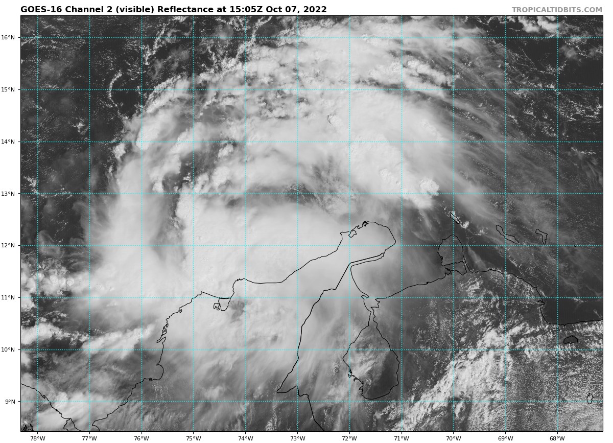
At 1100 AM EDT (1500 UTC), the center of Tropical Storm Julia was located near latitude 12.7 North, longitude 73.1 West. Julia is moving toward the west near 18 mph (30 km/h). A westward motion with some decrease in forward speed is expected through Sunday. On the forecast track, the center of Julia is expected to move across the southwestern Caribbean Sea during the next couple of days, passing near San Andres and Providencia Islands Saturday evening, and reaching the coast of Nicaragua Sunday morning. After landfall, Julia or its remnants are expected to turn west-northwestward and move across Central America through Monday.
Data from an Air Force Reserve Hurricane Hunter aircraft indicate that maximum sustained winds have increased to near 40 mph (65 km/h) with higher gusts. Additional strengthening is forecast, and Julia is expected to become a hurricane by Saturday evening before it reaches San Andres and Providencia Islands, and the coast of Nicaragua.
Tropical-storm-force winds extend outward up to 80 miles (130 km) from the center. The minimum central pressure is 1002 mb (29.59 inches) based on data from the reconnaissance aircraft.
HAZARDS AFFECTING LAND
———————-
WIND: Hurricane conditions are expected on the Colombian islands of San Andres, Providencia, and Santa Catalina by Saturday evening, with tropical storm conditions possible by Saturday afternoon. Hurricane conditions are possible along the coast of Nicaragua within the watch area Sunday morning, with tropical storm conditions possible by Saturday night.
Tropical storm conditions are expected along the coast of Colombia within the warning area for a few more hours. Tropical storm conditions are possible within the watch area in Honduras Sunday morning.
RAINFALL: Julia is expected to produce the following rainfall accumulations through early Monday:
Guajira Peninsula…3 to 6 inches, isolated 10 inches.
San Andres and Providencia…6 to 12 inches
Portions of Central America…5 to 10 inches, isolated 15 inches.
This rainfall may cause life-threatening flash floods and mudslides through this weekend.
STORM SURGE: A storm surge is likely to raise water levels by as much as 2 to 4 feet above normal tide levels along the immediate coast in areas of onshore winds on San Andres, Providencia, and Santa Catalina Islands. Near the coast, the surge will be accompanied by large and damaging waves.
A storm surge could raise water levels by as much as 4 to 6 feet above normal tide levels along the immediate coast of Nicaragua in areas of onshore winds. Large and damaging waves will likely accompany the storm surge near the coast.
SURF: Swells affecting the ABC Islands and portions of the coasts of northwestern Venezuela and the Guajira Peninsula of Colombia should subside today. Swells are forecast to spread westward and reach Jamaica tonight, Providencia and San Andres Islands on Saturday, and portions of the coast of Central America on Saturday night and Sunday. These swells are likely to cause life-threatening surf and rip current conditions. Please consult products from your local weather office.
About the Author (Author Profile)
Scott Martin is an operational meteorologist, professional graphic artist, musician, husband, and father. Not only is Scott a member of the National Weather Association, but he is also the Central Alabama Chapter of the NWA president. Scott is also the co-founder of Racecast Weather, which provides forecasts for many racing series across the USA. He also supplies forecasts for the BassMaster Elite Series events including the BassMaster Classic.Subscribe
If you enjoyed this article, subscribe to receive more just like it.


