Cool Weekend Ahead; Rain Returns Next Thursday
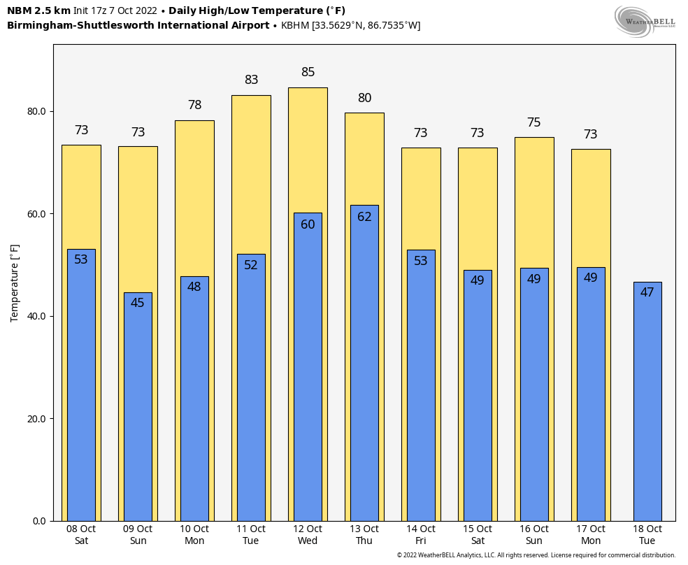
COOLER OVER THE WEEKEND: Temperatures are in the low to mid 80s across much of Alabama this afternoon, but a dry cold front passing through this evening will drop temperatures about ten degrees over the weekend. Look for highs in the 72-76 degree range, and lows well down in the 40s by early Sunday morning. Colder spots across North Alabama will likely visit the 30s for the first time this season. The air remains dry and we will see sunny days and clear nights.
NEXT WEEK: Dry weather continues Monday and Tuesday with a warming trend; highs rise into the low 80s by Tuesday and Wednesday. An approaching cold front will bring a chance of badly needed rain to Alabama Wednesday night and Thursday… rain amounts won’t be too heavy, however, with amounts mostly under 1/2 inch. But, at least it will settle the dust in most places. Cooler, drier air returns Friday.
Some notes on the dry conditions (based on data at Birmingham)…
*Today is the 12th consecutive day with no measurable rain.
*Our last measurable rain was on September 25, but the amount was only 0.03″.
*We have gone without measurable rain on 26 of the last 27 days.
*The last day with over one tenth of an inch of rain came on September 4, when the total was 1.55″.
FOOTBALL WEATHER: Another delightful evening for high school football games across the state tonight; the sky will be clear with temperatures falling into the 60s.
Auburn travels to Athens tomorrow to take on the Georgia bulldogs (2:30p CT kickoff)… the sky will be sunny; about 75 degrees at kickoff, falling to near 70 by the final whistle. UAB has a home game in downtown Birmingham tomorrow at Protective Stadium against Middle Tennessee (also a 2:30p CT kickoff)… it will be sunny afternoon with temperatures falling from around 73 degrees at kickoff into the upper 60s by the final whistle.
Then, tomorrow night Alabama hosts Texas A&M (7p CT kickoff) at Bryant-Denny Stadium in Tuscaloosa; the sky will be clear with temperatures falling from 67 degrees at kickoff into the 50s by the fourth quarter. A perfect night for football.
TROPICS: Tropical Storm Julia has formed in the Caribbean… headed for Nicaragua with landfall coming Sunday morning as a category one hurricane. After landfall, the track guidance currently indicates that Julia and its remnants should remain over Central America and southern Mexico through Tuesday.
Too early to know if any remnant circulation will be around to emerge into either the Pacific or the Bay of Campeche. Most likely the system dissipates over land.
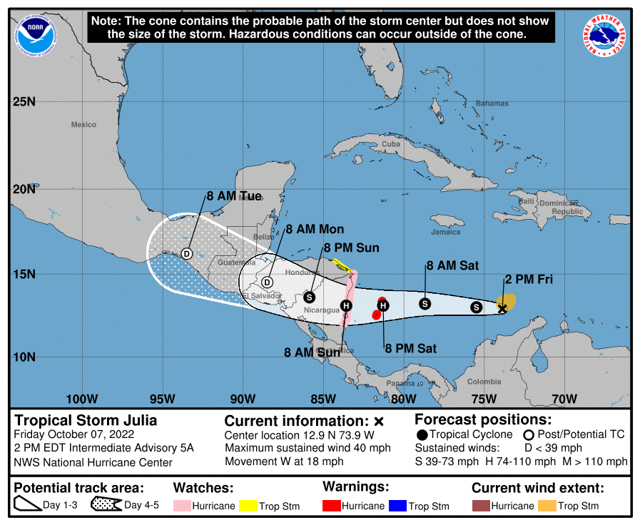
The rest of the Atlantic basin is very quiet.
ON THIS DATE IN 2018: Only 8 hours after becoming a depression, the National Hurricane Center upgraded the system to Tropical Storm Michael. Tropical storm force winds and torrential downpours were affecting portions of the coastal east-central Yucatan Peninsula. Michael would go to to become a category five hurricane with landfall near Mexico Beach, Florida a few days later.
BEACH FORECAST: Click here to see the AlabamaWx Beach Forecast Center page.
Look for my next Weather Briefing video here by 6:00 a.m. Monday… enjoy the weekend!
Category: Alabama's Weather, ALL POSTS
About the Author (Author Profile)
James Spann is one of the most recognized and trusted television meteorologists in the industry. He holds the AMS CCM designation and television seals from the AMS and NWA. He is a past winner of the Broadcast Meteorologist of the Year from both professional organizations.Subscribe
If you enjoyed this article, subscribe to receive more just like it.


