Rain Returns Wednesday Afternoon/Night
ANOTHER COLD START: Here are some temperatures across Alabama just before sunrise…
Oneonta 34
Scottsboro 37
Gadsden 38
Meridianville 38
Cullman 39
Decatur 39
Pell City 39
Talladega 40
Cottondale 40
Anniston 42
Birmingham 45
Montgomery 46
Tuscaloosa 47
Dothan 53
Mobile 57
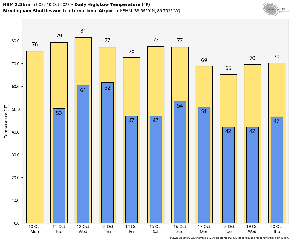
Look for a big warm-up across Alabama today with a high in the 77-80 degree range; the sky will stay sunny. Afternoon temperatures will reach the low 80s tomorrow with a partly to mostly sunny sky.
RAIN RETURNS: Clouds return Wednesday, and we will forecast a good chance of showers and a few thunderstorms Wednesday afternoon into Wednesday night. For now it looks like the main window for rain will come from about 3:00 p.m. Wednesday to 3:00 a.m. Thursday… rain amounts of 1/2 to 1 inch are expected for most of the state. We also note there is a low end “marginal risk” of severe thunderstorms Wednesday evening for the Tennessee Valley…
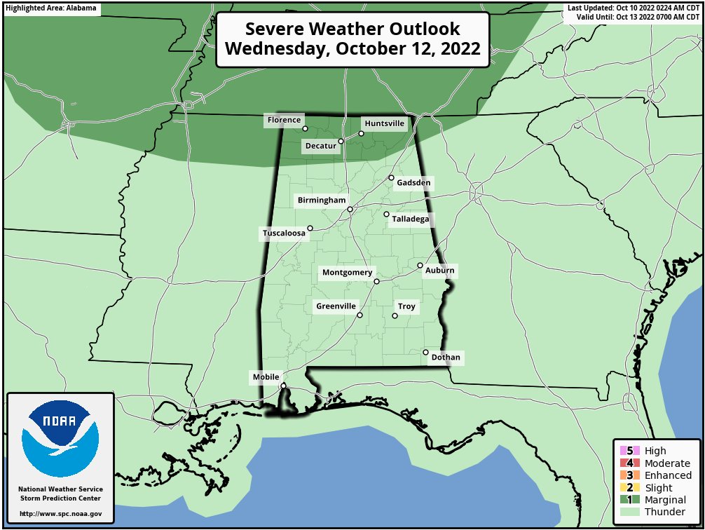
A storms there could produce gusty winds and maybe some small hail, but this is not a major severe weather threat.
For most of Alabama, this will be the first rain since September 25 (the rain total that day in Birmingham was only 0.03″)… and the first really meaningful rain event since September 4, when Birmingham measured 1.55″.
THURSDAY THROUGH THE WEEKEND: The sky becomes mostly sunny Thursday as dry air returns; the high will be in the mid 70s. Then, sunny weather continues on Friday and Saturday… Friday’s high will be in the low 70s followed by upper 70s Saturday. Then, a cold front will bring a chance of showers to the state late Sunday and Sunday night… for now it looks like moisture will be limited and rain amounts will be light. The high Sunday will be in the 74-77 degree range with a partly sunny sky.
NEXT WEEK: For now most of the week looks cool and dry with highs in the 60s and 70s, and lows mostly in the 40s. See the daily Weather Briefing video for maps, graphics, and more details.
TROPICS: Tropical Julia is expected to dissipate tonight over Guatemala. The Atlantic basin is now very quiet, and tropical storm formation is not expected for at least the next five days. Hurricane season ends on November 30.
ON THIS DATE IN 1846: A major hurricane, likely a Category 5, moved through the Caribbean Sea. This Great Havana Hurricane struck western Cuba on 10 October. It hit the Florida Keys on 11 October, destroying the old Key West Lighthouse and Fort Zachary Taylor.
ON THIS DATE IN 2009: Nome, Alaska, experiences its first-ever October thunderstorm with five lightning strikes between 8 and 9 PM ADT.
BEACH FORECAST: Click here to see the AlabamaWx Beach Forecast Center page.
Look for the next Weather Xtreme video here by 3:00 this afternoon… enjoy the day!
Category: Alabama's Weather, ALL POSTS, Weather Xtreme Videos
About the Author (Author Profile)
James Spann is one of the most recognized and trusted television meteorologists in the industry. He holds the AMS CCM designation and television seals from the AMS and NWA. He is a past winner of the Broadcast Meteorologist of the Year from both professional organizations.Subscribe
If you enjoyed this article, subscribe to receive more just like it.


