

Rain Returns At Mid-Week; Dry Air Returns Thursday
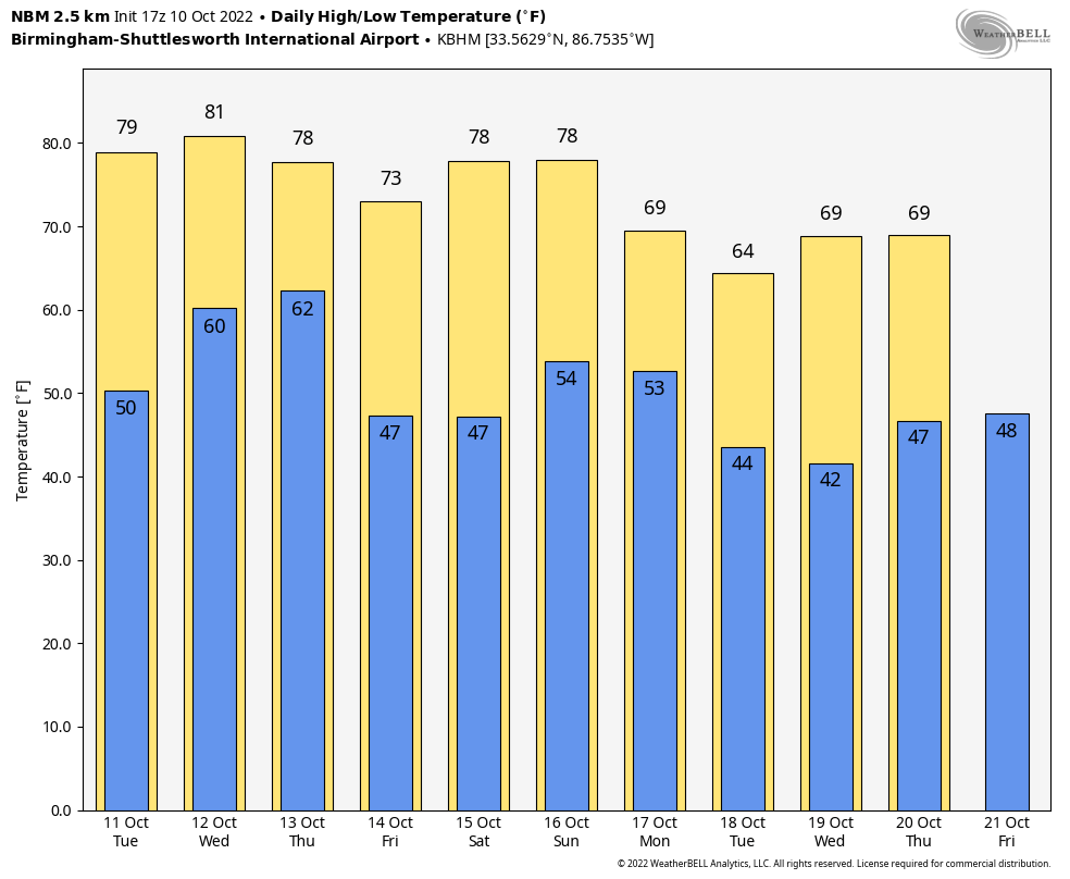
BIG WARM-UP: After temperatures in the 35-45 degree range in most places early this morning, we are in the mid to upper 70s this afternoon with sunshine in full supply. One way of knowing a very dry airmass remains in place across Alabama. At mid-afternoon, Maxwell AFB in Montgomery reports 76 degrees with a dew point of 25, making the relative humidity only 15 percent. About as low as it gets around here.
Tomorrow will be a sunny day with a warm afternoon; temperatures reach the 82-85 degree range.
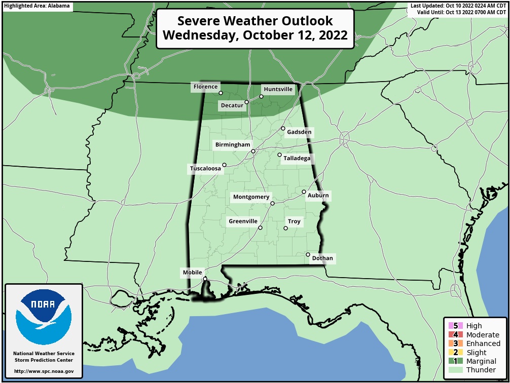
RAIN RETURNS: Clouds will move in Wednesday ahead of a cold front, and we are maintaining a good chance of showers and a few thunderstorms in the forecast for Wednesday afternoon and Wednesday night. New guidance suggests most of the rain will come from about 4:00 p.m. Wednesday through 4:00 a.m. Thursday; rain amounts should average around 1/2 inch, but isolated totals to 1 inch are possible.
SPC has defined a low end, “marginal risk” of severe thunderstorms for the Tennessee Valley Wednesday evening… heavier storms could produce gusty winds and possibly some small hail, but this is not a major severe weather threat.
Dry air returns during the day Thursday… the sky becomes partly to mostly sunny with a high in the mid 70s.
FRIDAY AND THE WEEKEND: For now the weather looks dry with sunny days and fair nights Friday through Sunday. The high Friday will be in the upper 70s, and not too far from 80 degrees over the weekend. Lows will be in the 40s and 50s. Some clouds could reach the state late in the day Sunday, but new model data suggests showers will stay west of Alabama.
NEXT WEEK: A disturbance will bring some risk of showers to the state Monday, and possibly again Wednesday, otherwise the week looks cool and dry with highs mostly in the 60s. See the daily Weather Briefing video for maps, graphics, and more details.
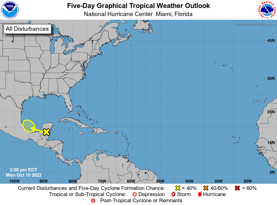
TROPICS: Julia is now a tropical depression over Central America, and is forecast to dissipate tonight over Guatemala. Elsewhere, A trough of low pressure over the Yucatan Peninsula is producing disorganized showers and a few thunderstorms. Some development of this system is possible tomorrow and Wednesday when the system moves slowly west-northwestward to northwestward over the far southwestern Gulf of Mexico. Increasing upper-level winds should prevent significant development late this week; it is no threat to the U.S.
The rest of the Atlantic basin is very quiet.
ON THIS DATE IN 2018: Hurricane Michael made landfall near Mexico Beach and Tyndall Air Force Base, Florida.
Michael is the first hurricane to make landfall in the United States as a category 5 since Hurricane Andrew in 1992, and only the fourth on record. The others are the Labor Day Hurricane in 1935 and Hurricane Camille in 1969.
Michael is also the strongest hurricane landfall on record in the Florida Panhandle and only the second known category 5 landfall on the northern Gulf coast.
At least 74 deaths were attributed to the storm, including 59 in the United States and 15 in Central America.
Along the Florida panhandle, the cities of Mexico Beach and Panama City suffered the worst of Michael, with catastrophic damage reported due to the extreme winds and storm surge. Numerous homes were flattened and trees felled over a wide swath of the panhandle. A maximum wind gust of 139 mph was measured at Tyndall Air Force Base before the sensors failed.
BEACH FORECAST: Click here to see the AlabamaWx Beach Forecast Center page.
Look for the next Weather Briefing video here by 6:00 a.m. tomorrow…
Category: Alabama's Weather, ALL POSTS, Weather Xtreme Videos
About the Author (Author Profile)
James Spann is one of the most recognized and trusted television meteorologists in the industry. He holds the AMS CCM designation and television seals from the AMS and NWA. He is a past winner of the Broadcast Meteorologist of the Year from both professional organizations.Subscribe
If you enjoyed this article, subscribe to receive more just like it.


