Dry Today; Rain/Storms Return Tomorrow
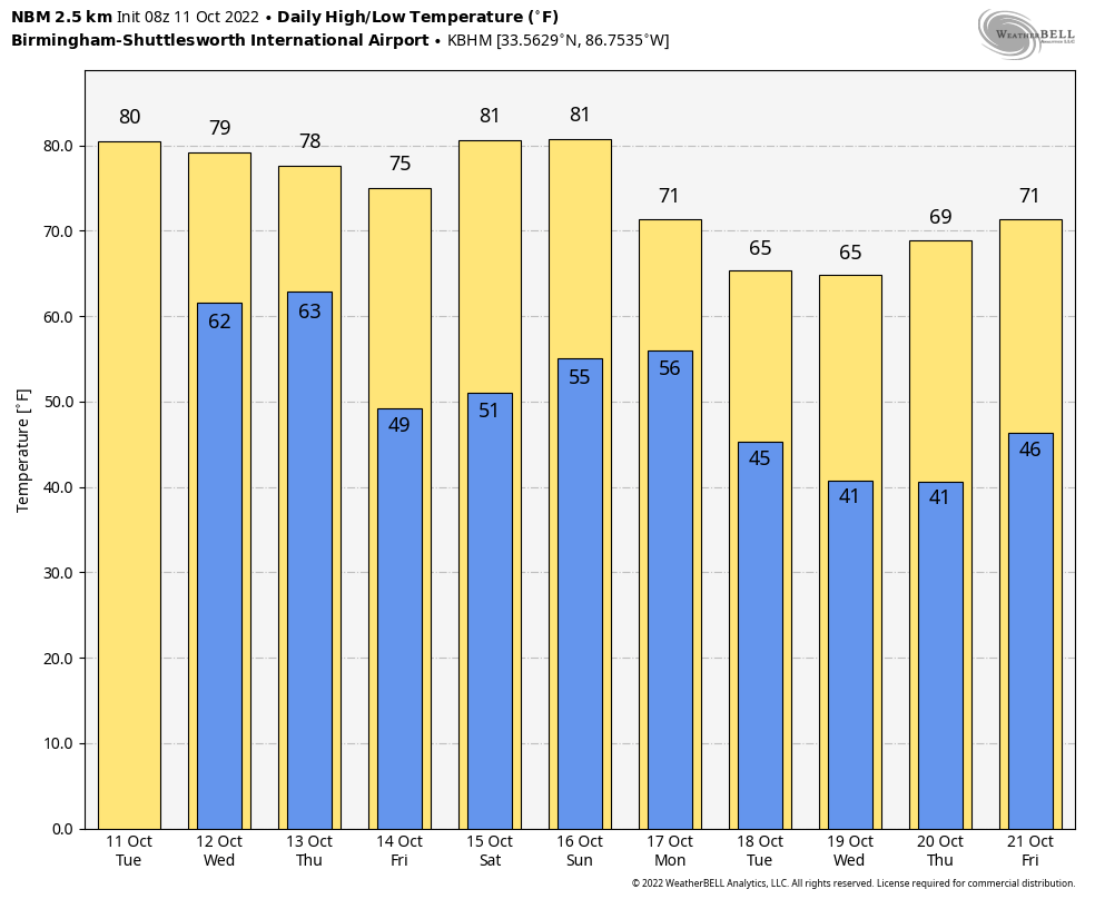
ANOTHER BIG WARM-UP: We are forecasting a high in the 81-85 degree range across Alabama today with a sunny sky… the average high for Birmingham on October 11 is 78. Clouds will increase late tonight as moist air returns.
RAIN RETURNS: Tomorrow will be a mostly cloudy day with developing showers, and possibly a thunderstorm. This won’t be an “all day” rain, but occasional showers are likely. Then, an organized line of storms is likely along a cold front late tomorrow night.
SPC has expanded the “marginal risk” (level 1/5) of severe thunderstorms to include areas as far south as Thomasville, Prattville, and Wedowee.
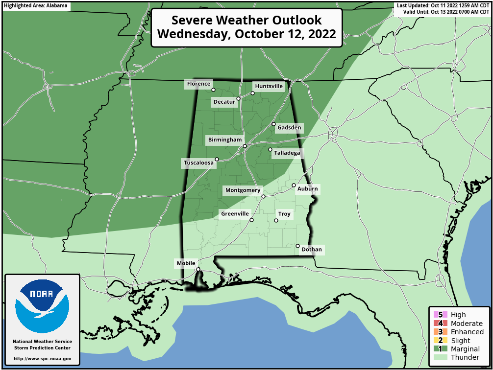
The air will become unstable across Alabama tomorrow afternoon and tomorrow night, and model data suggests there could be enough shear for a few rotating updrafts, meaning the risk of a brief isolated tornado or two. Strong storms will also be capable of producing strong straight line winds and some small hail. The main window for heavier storms will come from about 3:00 p.m. tomorrow through 3:00 a.m. Thursday. While this isn’t a “major” severe weather threat, it is always a good idea to be sure you can hear severe weather warnings if they are needed.
On the positive side, rain amounts of 1/2 to 1 inch look likely now for most of the state, with potential for isolated heavier amounts. This will be ending a long dry spell…. these notes are based on data from Birmingham:
*This will be the 16th consecutive day with no measurable rain.
*There has been no measurable rain on 29 out of the last 30 days.
*The last measurable rain was on September 25, and the total was only 0.03”
*The last really big rain day here was on September 4, when the total was 1.55”
Showers and storms will likely end by daybreak Thursday, and the sky becomes partly to mostly sunny with a high in the upper 70s.
FRIDAY AND THE WEEKEND: Look for sunny weather Friday and Saturday with cool mornings and warm afternoons; highs will be in the low 80s, but lows will be in the 40s and 50s. The sky will be partly sunny Sunday, and a cold front could push a few showers into the state Sunday night as the weekend wraps up. Probably not a big rain event with limited moisture. The high Sunday will be in the low 80s.
NEXT WEEK: Noticeably cooler air rolls into next week; highs drop into the 60s on most days with lows in the 30s and 40s; many places over the northern half of the state could experience their first frost of the season by mid-week. And, for now much of the week looks dry. See the daily Weather Briefing video for maps, graphics, and more details.
TROPICS: A trough of low pressure over southeastern Mexico is producing a large area of showers and thunderstorms over the Bay of Campeche and adjacent land areas. This system is forecast to move slowly northwestward over the southwestern Gulf of Mexico later this morning. Environmental conditions are expected to conducive for some development, and a tropical depression could from within the next day or two while the system meanders over the southwestern Gulf of Mexico. After that time, increasing upper-level winds are likely to hinder additional development. This system is no threat to the U.S…. and the rest of the Atlantic basin is very quiet.
ON THIS DATE IN 1846: A major hurricane, possibly a Category 5, moved through the Caribbean Sea. This Great Havana Hurricane struck western Cuba on 10 October. It hit the Florida Keys on 11 October, destroying the old Key West Lighthouse and Fort Zachary Taylor.
ON THIS DATE IN 1906: Games 1 and 2 of all Chicago World Series were played amid snow flurries. Snow would not happen again in a World Series until 1997. The high temperature for game 3 played on this day was 43 degrees.
BEACH FORECAST: Click here to see the AlabamaWx Beach Forecast Center page.
Look for the next Weather Briefing video here by 3:00 this afternoon… enjoy the day!
Category: Alabama's Weather, ALL POSTS, Weather Xtreme Videos
About the Author (Author Profile)
James Spann is one of the most recognized and trusted television meteorologists in the industry. He holds the AMS CCM designation and television seals from the AMS and NWA. He is a past winner of the Broadcast Meteorologist of the Year from both professional organizations.Subscribe
If you enjoyed this article, subscribe to receive more just like it.


