Shower/Storms Arrive Tomorrow
STILL DRY: Alabama’s long dry spell continues this afternoon; the sky is partly to mostly sunny with temperatures generally in the 76-82 degree range at mid-afternoon. Some notes on the dry conditions on the eve of rain returning to the state…
*This is the 16th consecutive day with no measurable rain.
*There has been no measurable rain on 29 out of the last 30 days.
*The last measurable rain was on September 25, and the total was only 0.03”
*The last really big rain day here was on September 4, when the total was 1.55”
RAIN RETURNS: Moist air moves into Alabama late tonight, and it now looks like showers and storms will develop across the state as early as tomorrow morning. We expect period of rain and a few storms through the afternoon, and a few strong storms are possible. SPC has trimmed back the “marginal risk” of severe thunderstorms for tomorrow; it now includes areas north of a line from near Demopolis to Birmingham to Fort Payne.
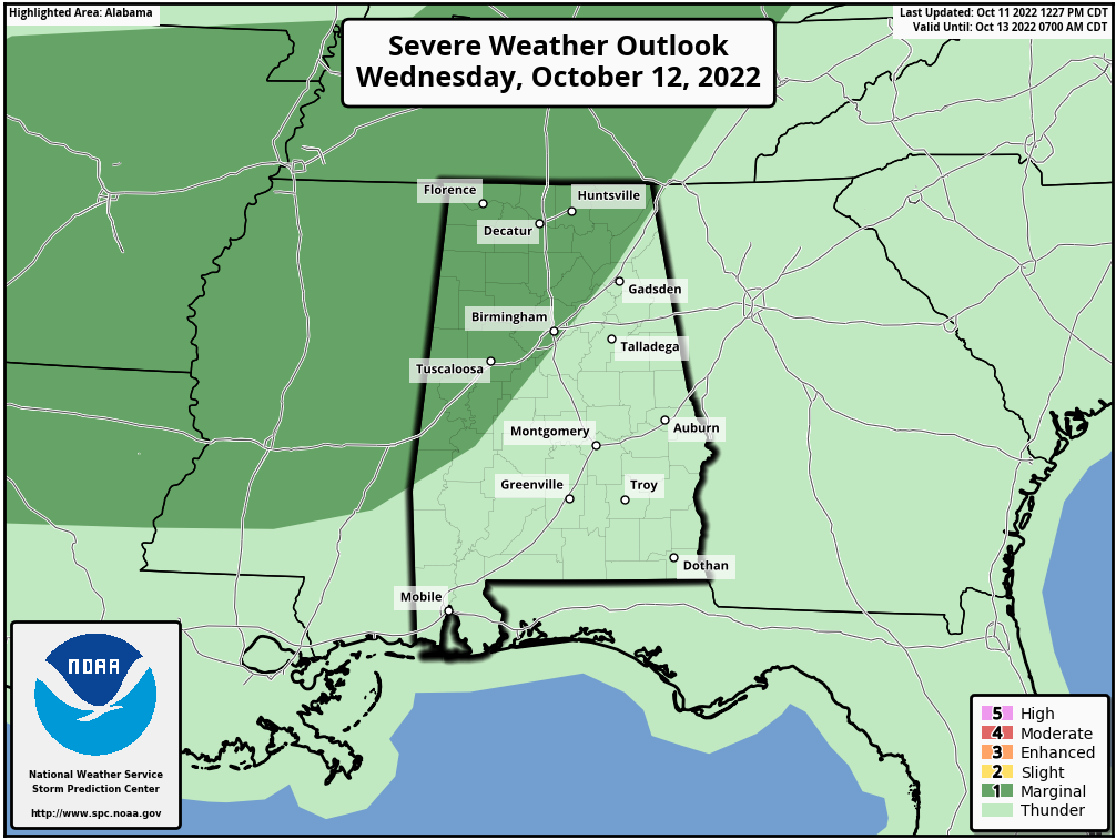
Storms over North and West Alabama tomorrow afternoon could produce strong gusty winds and some small hail. A line of thunderstorms will move through the state late tomorrow night ahead of a cold front, but it now looks like severe storms are not likely with the frontal passage due to the lack of surface based instability at that time, along with weak dynamic support. Overall not a major severe weather threat over the next 36 hours, but as always we will watch the storms carefully.
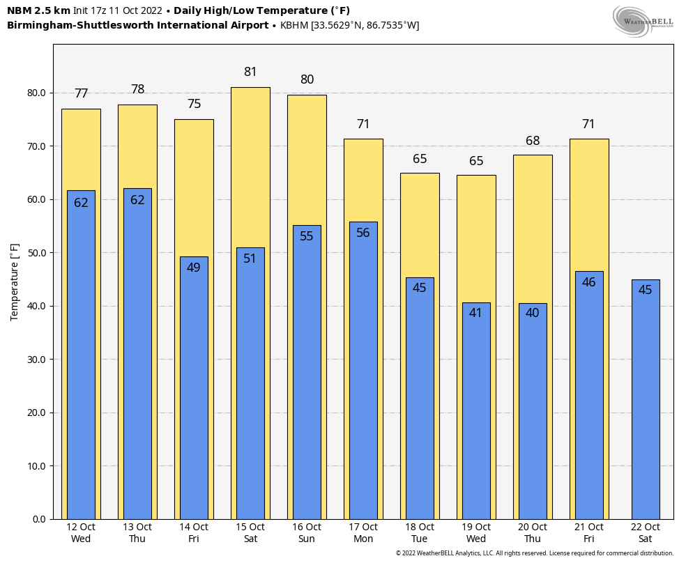
On the positive side, most places will see 1/2 to 1 inch of rain with the event; isolated heavier amounts are possible. It will be our biggest rain event since September 4.
Showers will end during the pre-dawn hours Thursday; the sky becomes partly to mostly sunny during the day with a high in the upper 70s.
FRIDAY AND THE WEEKEND: Friday and Saturday will feature a mostly sunny sky with cool mornings and warm afternoons. Lows will be in the 40s and 50s, but highs will be in the low 80s both days. New model data suggests some risk of showers Saturday night and Sunday as a cold front passes slowly through the stare; rain amounts will be light for most places, generally 1/4″ or less. Sunday won’t be a “rainy day”, but just know spotty showers are possible. Sunday’s high will be in the mid 70s.
NEXT WEEK: Noticeably cooler rolls into the state, and highs for much of the week will be in the 60s, with lows in the 30s and 40s. Many North Alabama communities could see their first frost of the season by the middle of next week. And, for now, much of the week looks dry. See the daily Weather Briefing video for maps, graphics, and more details.
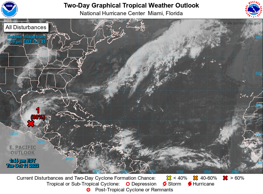
TROPICS: Satellite-derived surface winds indicate that the area of low pressure over the Bay of Campeche is becoming better defined. Environmental conditions are forecast to be conducive for further development, and a tropical depression or tropical storm is likely to form within the next day or so while the system moves slowly northwestward over the southwestern Gulf of Mexico. Heavy rainfall is also expected over portions of southern Mexico during the next couple of days. An Air Force Reserve reconnaissance aircraft is en route to investigate the system.
If the system becomes a tropical storm, the name will be “Karl”. But, it should be short lived as strong winds aloft will move in later this week, and the system is not expected to impact the U.S. The rest of the Atlantic basin is very quiet.
ON THIS DATE IN 1846: A major hurricane, possibly a Category 5, moved through the Caribbean Sea. This Great Havana Hurricane struck western Cuba on 10 October. It hit the Florida Keys on 11 October, destroying the old Key West Lighthouse and Fort Zachary Taylor.
ON THIS DATE IN 1906: Games 1 and 2 of all Chicago World Series were played amid snow flurries. Snow would not happen again in a World Series until 1997. The high temperature for game 3 played on this day was 43 degrees.
BEACH FORECAST: Click here to see the AlabamaWx Beach Forecast Center page.
Look for the next Weather Briefing video here by 6:00 a.m. tomorrow…
Category: Alabama's Weather, ALL POSTS, Weather Xtreme Videos
About the Author (Author Profile)
James Spann is one of the most recognized and trusted television meteorologists in the industry. He holds the AMS CCM designation and television seals from the AMS and NWA. He is a past winner of the Broadcast Meteorologist of the Year from both professional organizations.Subscribe
If you enjoyed this article, subscribe to receive more just like it.


