Occasional Showers; A Few Strong Storms
RADAR CHECK: Alabama’s long dry spell is coming to an end. Showers are in progress early this morning over the northern half of the state, and we expect periods of rain statewide over the next 24 hours. A few thunderstorms will be involved as well; SPC has now defined a “slight risk” (level 2/5) of severe thunderstorms for the northwest corner of the state around the Shoals… and a “marginal risk” (level 1/5) as far south as Grove Hill, Montgomery, and Roanoke.
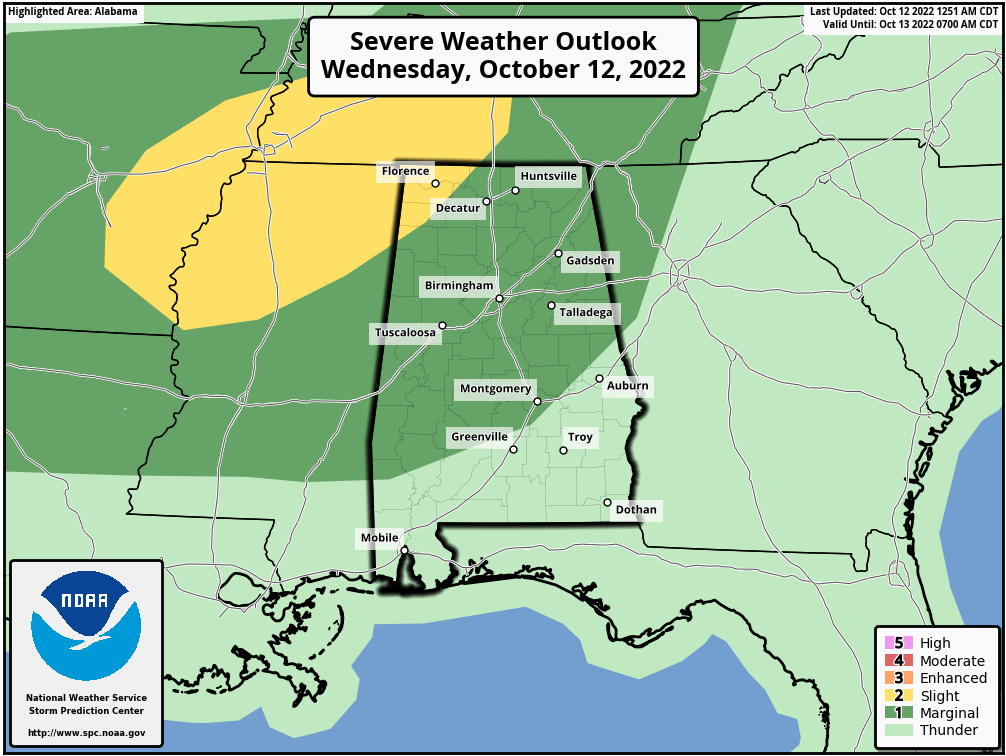
The main concern with heavier thunderstorms this afternoon and tonight will be from strong, gusty straight line winds, but some small hail is possible as well. A brief, isolated tornado can’t be totally ruled out in the “slight risk” area over the northwest corner of the state, but overall this is a fairly low end threat. But, as always, we will be watching radar trends closely. The main window for the heavier storms will come from about 4 p.m. until midnight.
A line of storms will move through after midnight ahead of a cold front, but by then instability values will be fading, and dynamic support will be weak.
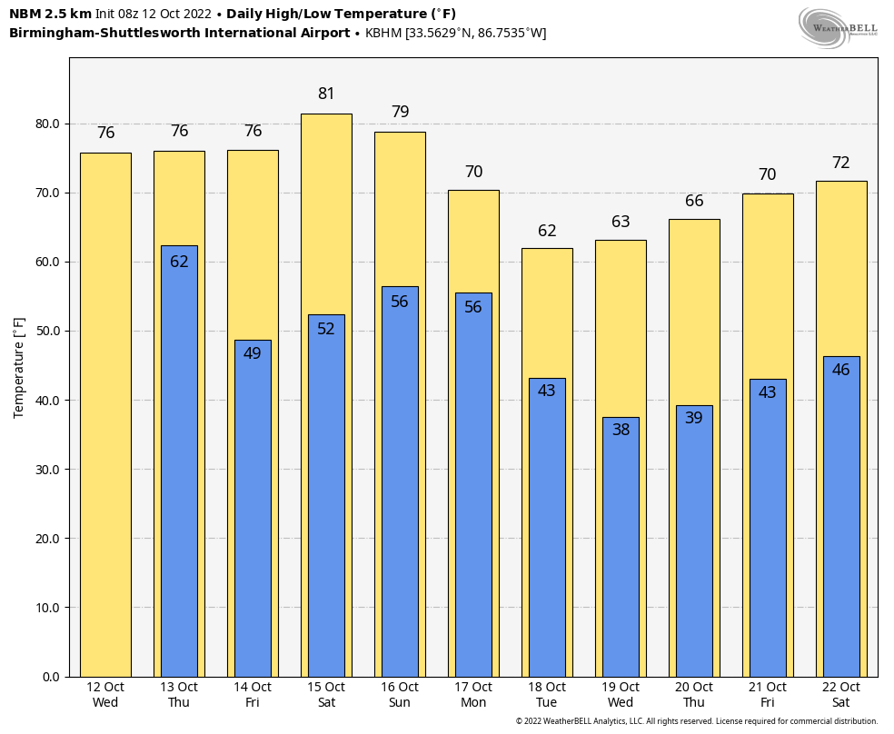
On the positive side, rain amounts of 1/2 to 1 inch are a good possibility statewide over the next 24 hours. This will be our biggest rain event since September 5, when Birmingham measured 1.55″.
The sky becomes partly to mostly sunny tomorrow as dry air returns… the high will be in the 75-79 degree range.
FRIDAY AND THE WEEKEND: Friday and Saturday will be dry with cool mornings and warm afternoons. We start the day Friday with temperatures well down in the 40s, but warm to near 80 degrees by afternoon. Saturday’s high will be in the low 80s with a good supply of sunshine. Then, on Sunday, we will mention the chance of a few spotty, scattered showers ahead of a slow moving cold front. Not a rainy day at all, but just understand a few showers will be around if you have something planned outdoors. Sunday’s high will be in the upper 70s.
NEXT WEEK: We will maintain the chance of a few scattered showers Monday as the front continues moving slowly southward, then the rest of the week looks dry. The coolest air so far this season will cover the Deep South for most of the week with highs in the 60s, and much of North/Central Alabama will likely see the first widespread front of the season by Wednesday morning with lows well down in the 30s. See the daily Weather Briefing video for maps, graphics, and more details.
FOOTBALL WEATHER: Another perfect night for high school football games across Alabama Friday night; the sky will be clear with temperatures falling from the mid 70s at kickoff into the 60s by the second half.
Saturday Auburn travels to Oxford to play Ole Miss (11a CT kickoff)… the sky will be partly sunny, and there is an outside risk of a passing shower during the game. Temperatures will rise from near 78 at kickoff into the low 80s by the second half.
Alabama will take on Tennessee in Knoxville (2:30p CT kickoff)… the sky will be partly sunny; about 77 degrees at kickoff, falling to near 70 by the final whistle. There is a small risk of a shower by the end of the game, but the better chance of rain there will come Saturday night.
UAB will host Charlotte at Protective Stadium in downtown Birmingham Saturday (2:30p CT kickoff)… expect a mostly sunny sky; about 82 at kickoff, upper 70s by the fourth quarter.
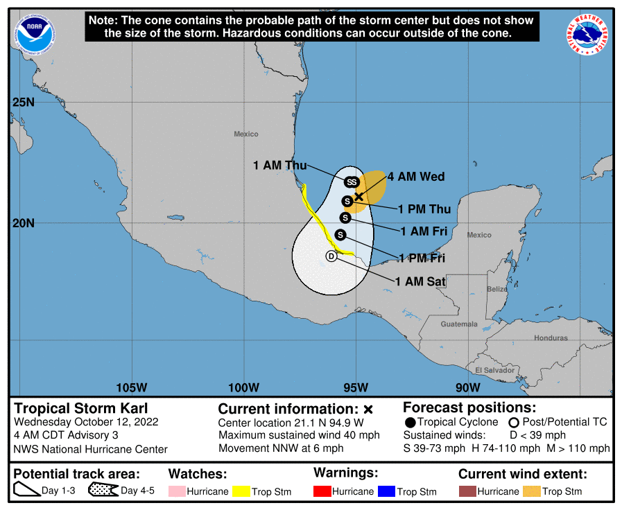
TROPICS: Tropical Storm Karl is in the far Southwest Gulf of Mexico this morning with sustained winds of 40 mph; it will move into the coast of Mexico Friday evening far south of Brownsville, Texas. The rest of the Atlantic basin is very quiet, and additional tropical storm formation is not expected through early next week.
ON THIS DATE IN 1962: The Columbus Day Storm of 1962 was a Pacific Northwest windstorm that struck the West Coast of Canada and the Pacific Northwest Coast of the United States. It is considered the benchmark of extratropical wind storms. The storm ranks among the most intense to strike the region since at least 1948, likely since the January 9, 1880 “Great Gale” and snowstorm
ON THIS DATE IN 1979: The lowest barometric pressure ever recorded occurs in the center of Typhoon Tip on this day. A fly reconnaissance mission recorded the low pressure of 870 hPa or 25.69″. Typhoon Tip was the most extensive tropical cyclone on record with a wind diameter of 1380 miles at its peak.
BEACH FORECAST: Click here to see the AlabamaWx Beach Forecast Center page.
Look for the next Weather Xtreme video here by 3:00 this afternoon… enjoy the day!
Category: Alabama's Weather, ALL POSTS, Weather Xtreme Videos
About the Author (Author Profile)
James Spann is one of the most recognized and trusted television meteorologists in the industry. He holds the AMS CCM designation and television seals from the AMS and NWA. He is a past winner of the Broadcast Meteorologist of the Year from both professional organizations.Subscribe
If you enjoyed this article, subscribe to receive more just like it.


