Big Warm-Up Today; Much Colder Next Week
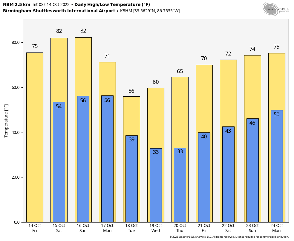
BIG WARM-UP: Temperatures are in the 35-45 degree range over the northern half of the state early this morning, but look for a big warm-up today with highs approaching 80 degrees this afternoon. The air is very dry, and the sky will be sunny.
Tomorrow will be another sunny, warm day as the weekend begins… the high will be in the low 80s. For most of the state Sunday stays warm and dry, but a few isolated showers could pop up late in the day across the northern quarter of the state ahead of a cold front. Moisture will be very limited, and most places will stay dry. Sunday’s high will be in the low 80s, about 7 degrees above average for mid-October.
NEXT WEEK: The coldest air so far this season rolls into Alabama. Monday will feature a partly sunny sky with a high in the low 70s, but on Tuesday expect a high in the 54-59 degree range with a very cool north breeze. Temperatures will drop into the 25-35 degree range by early Wednesday and Thursday morning over the northern 2/3 of the state; for many places it will be the first freeze of the season. Frost will be widespread, even down into parts of South Alabama. Temperatures begin to warm up late in the week with highs back in the low 70s, by Friday, and the week will be rain-free. See the daily Weather Briefing video for maps, graphics, and more details.
FOOTBALL WEATHER: Another perfect night for high school football games across Alabama tonight; the sky will be clear with temperatures falling from the mid 70s at kickoff into the 60s by the second half.
Tomorrow Auburn travels to Oxford to play Ole Miss (11a CT kickoff)… the sky will be mostly sunny… temperatures will rise from near 78 at kickoff into the low 80s by the second half.
Alabama will take on Tennessee in Knoxville (2:30p CT kickoff)… the sky will be mostly sunny; about 77 degrees at kickoff, falling to near 70 by the final whistle.
UAB will host Charlotte at Protective Stadium in downtown Birmingham tomorrow (2:30p CT kickoff)… expect a mostly sunny sky; about 82 at kickoff, upper 70s by the fourth quarter.
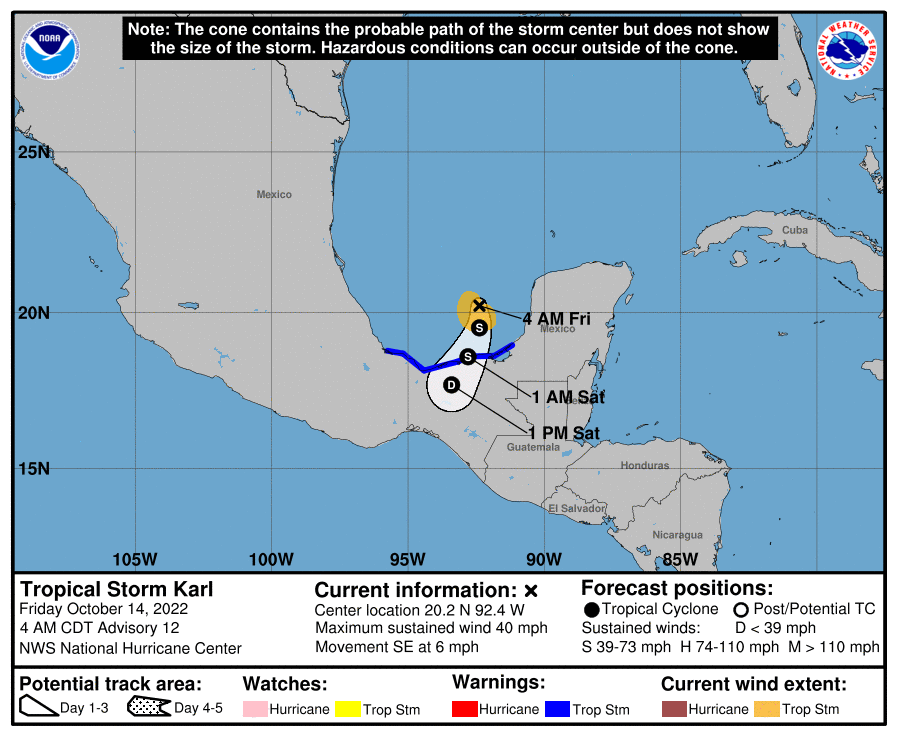
TROPICS: Tropical Storm Karl is a weak system in the far Southwest Gulf of Mexico (the Bay of Campeche)… winds have dropped to 40 mph, and landfall comes tonight on the southern coast of Mexico far south of Texas.
Elsewhere, an area of disorganized showers and thunderstorms located several hundred miles south of the Cabo Verde Islands (the far eastern Atlantic) is associated with a tropical wave. Environmental conditions appear marginally conducive for some gradual development during the next few days while the system moves westward and then west-northwestward at about 10 mph. However, the disturbance is expected to move into a less favorable area of stronger upper-level winds by early next week. NHC gives it only a 20 percent chance of development over the next five days.
The rest of the Atlantic basin is very quiet.
ON THIS DATE IN 1941: America’s first television weather forecast was broadcast on New York’s WNBT (later WNBC). There weren’t many televisions at that time, so viewers were limited to perhaps a few hundred people. The weathercast consisted of a sponsor’s message followed by a text screen containing the next day’s forecast.
ON THIS DATE IN 1984: Dense fog contributes to a 118 vehicle accident on I-94, just south of Milwaukee. At the time of the accident, the visibility was reportedly close to zero.
BEACH FORECAST: Click here to see the AlabamaWx Beach Forecast Center page.
I will post fresh forecast notes here this afternoon… enjoy the day!
Category: Alabama's Weather, ALL POSTS, Weather Xtreme Videos
About the Author (Author Profile)
James Spann is one of the most recognized and trusted television meteorologists in the industry. He holds the AMS CCM designation and television seals from the AMS and NWA. He is a past winner of the Broadcast Meteorologist of the Year from both professional organizations.Subscribe
If you enjoyed this article, subscribe to receive more just like it.


