Sunday’s Weather Briefing — Staying Dry Through Monday; Showers & Storms Possible on Tuesday
A GLORIOUS WAY TO END THE WEEKEND
Skies will start off with some clouds early on Sunday morning, but as the day progresses, those clouds will mostly dissipate. However, a few more clouds look to move in late after the sun sets. It will feel very nice as highs will be in the mid to upper 70s.
SHOWERS & STORMS POSSIBLE BEFORE MIDWEEK
Monday will be a dry day with partly to mostly sunny skies and highs in the upper 70s to the lower 80s. Clouds will be on the increase by Tuesday as a cold front approaches and begins to move through the area. While a few isolated to scattered showers and storms will be possible by mid to late afternoon, the main activity looks to move in the western locations by sunset. There will be minimal instability present, so a strong storm can’t be ruled out. However, severe weather is not likely. Highs in the mid 70s to the lower 80s.
Rain should be out of the area by sunrise on Wednesday as the front moves out of Central Alabama. Skies will start clearing out and highs will only make it up into the mid 60s to the mid 70s. Thursday looks to be a fantastic autumn day in Central Alabama, with plenty of sun and highs in the 70s.
Clouds will start to increase in Central Alabama on Friday as another impulse will be heading in our direction. At this point, we should stay dry until the late night hours, when showers and storms will begin to move into the western and southwestern locations. Highs in the lower 70s to the lower 80s.
NEXT WEEKEND
That impulse will continue to slowly move through the area on Saturday, keeping a chance of showers and storms in the forecast. Not everyone will get rain, as overall coverage doesn’t look to be all that impressive at this point. Highs in the mid 60s to the upper 70s. We’ll continue to keep some clouds and a small chance of showers in the forecast for Sunday as well as the impulse tries to rotate back around and form a low just off to our east and northeast. Highs in the mid 60s to the lower 70s.
THE TROPICS
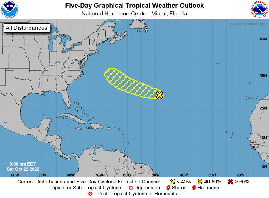
Central Subtropical Atlantic: A trough of low pressure located well to the east of Bermuda is producing limited shower activity. Although environmental conditions appear only marginally conducive for development during the next few days, the disturbance could still acquire some subtropical or tropical characteristics by early next week while it moves generally west-northwestward at 15 to 20 mph across the subtropical Atlantic. By the middle part of next week, further development appears unlikely as the system turns northward over the cooler waters of the northwestern Atlantic and encounters stronger upper-level winds.
* Formation chance through 48 hours… low… 10 percent.
* Formation chance through 5 days… low… 20 percent.
ON THIS DAY IN WEATHER HISTORY – 1987
Thirteen cities in the southeastern U.S. reported record low temperatures for the date. It marked the sixth record low of the month for Greer SC and Columbia SC, and the ninth of the month for Montgomery AL. Showers and thunderstorms deluged Corpus Christi, TX with five inches of rain. Winnemucca, NV reported their first measurable rain in ninety-two days, while Yakima, WA reported a record 96 days in a row without measurable rainfall.
Category: Alabama's Weather, ALL POSTS, Tropical, Weather Xtreme Videos
About the Author (Author Profile)
Scott Martin is an operational meteorologist, professional graphic artist, musician, husband, and father. Not only is Scott a member of the National Weather Association, but he is also the Central Alabama Chapter of the NWA president. Scott is also the co-founder of Racecast Weather, which provides forecasts for many racing series across the USA. He also supplies forecasts for the BassMaster Elite Series events including the BassMaster Classic.Subscribe
If you enjoyed this article, subscribe to receive more just like it.


