Strong/Severe Storms Possible Tomorrow Afternoon/Evening
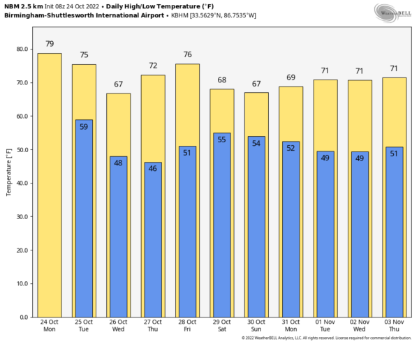
DRY AGAIN TODAY: Today will be another mostly sunny day across Alabama with a high close to 80 degrees this afternoon. But an active day is ahead tomorrow with a dynamic weather system approaching from the west. Clouds will increase, and winds will pick out out of the south, averaging 10-20 mph by afternoon.
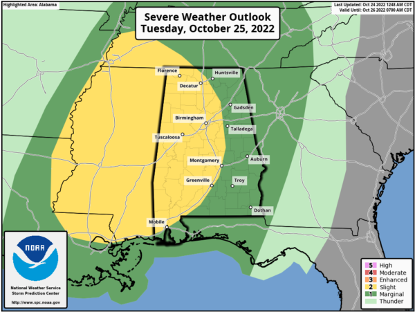
SPC has defined a “slight risk” (level 2/5) of severe thunderstorms west of a line from Athens to Pell City to Montgomery to Mobile, and a “marginal risk” (level 1/5) for the rest of the state (the eastern counties).
*The main window for strong to severe thunderstorms is from around 1:00 until 10:00 p.m. Higher severe weather probabilities are over the western half of the state; storms should weaken over East Alabama tomorrow night in a more stable airmass there.
*Storms tomorrow afternoon and evening will be capable of producing large hail and strong winds. A few tornadoes are possible over the western half of the state, in the level 2 risk area.
*Rain amounts of around one inch are likely for West Alabama, with amounts of 1/2 to 1 inch for the eastern counties.
It has been a while since we have had a severe weather threat; be sure you can hear severe weather warnings if they are needed. A NOAA Weather Radio is the baseline, and be sure WEA (Wireless Emergency Alerts) are enabled on your phone. Install the free ABC 33/40 weather app.
Review your severe weather plan; know the safe place in your home, which is a small room on the lowest floor. Near the center of the house, away from windows. And, if you live in a mobile home be sure you know the location of the nearest shelter or site built structure that is available, and the quickest way of getting there.
No need to be anxious, these setups are common in Alabama during our tornado season, which runs from November through May (this is a little pre-season action).
Dry weather returns to the state Wednesday and Thursday; the high Wednesday will be in the upper 60s, followed by low to mid 70s Thursday.
FRIDAY AND THE WEEKEND: The day Friday will be dry with a high in the 70s… but moisture will return Friday night. A shower can’t be ruled out in spots Friday night, but occasional showers are much more likely over the weekend. The weekend won’t be a total “wash-out”, but some rain from time to time is likely. There will be very little instability available, so there is no risk of severe storms, and we expect little thunder. Highs over the weekend will be in the 65-70 degree range for most communities.
NEXT WEEK: At this point global models are suggesting a chance of rain in the Tuesday-Wednesday time frame… highs will be mostly in the 70s through the week. See the daily Weather Briefing video for maps, graphics, and more details.
TROPICS: NHC is monitoring a couple of waves in the higher latitudes of the Atlantic, well east of the U.S. For now they have only a low chance of development… the Gulf of Mexico remains quiet. Hurricane season ends November 30.
ON THIS DATE IN 1878: The Gale of 1878 was an intense Category 2 hurricane that was active between October 18 and October 25. It caused extensive damage from Cuba to New England. Believed to be the strongest storm to hit the Washington – Baltimore region since hurricane records began in 1851.
BEACH FORECAST: Click here to see the AlabamaWx Beach Forecast Center page.
Look for the next Weather Briefing video here by 3:00 this afternoon… enjoy the day!
Category: Alabama's Weather, ALL POSTS, Weather Xtreme Videos


