Hurricane Sandy: The Rest of the Story
Ten years ago tonight, we were talking on WeatherBrains about the storm that emergency managers feared for New York City. But there is another side to Sandy that you may not know about. Paul Harvey had a show called The Rest of the Story. This is the rest of the story, hurricane Sandy style, from the pages of this week in weather history.
Back In October 1997, emergency management officials in New York ran a hurricane simulation for their area. The fictional storm was loosely based on the 1938 Long Island Express Hurricane, which caused extreme devastation on Long Island.
The practice hurricane was set to come inland on Saturday evening, October 4th as a category two hurricane just east of New York City. The advisories used in the drill were eerily predictive of what would happen just over fifteen years later as a very real and very serious Hurricane Sandy came ashore.
But there was something else that is even eerier today, given what we know now. That little piece of trivia is the Today in Weather History Rest of the Story.
The hallmark of the Long Island Express was that it struck literally without warning. The storm was moving at over 50 mph after it passed the Outer Banks on September 21, 1938. At 730 a.m. it was near Cape Hatteras. By 3 p.m. it was making landfall on Long Island. Without the benefit of satellite imagery, aircraft reconnaissance, and coastal radars, the U.S. Weather Bureau was literally flying blind. They were confident the storm would weaken as it moved over colder water. Turned out it didn’t have time.
On the other hand, Sandy is certainly one of the best forecast storms in history. Numerical weather prediction models did an excellent job a week in advance. But while the forecast was excellent, the communication wasn’t.
The one thing that was missing from the NHC advisories was hurricane warnings. Sandy was in the process of turning into a powerful nor’easter. Because of this, by rule, the National Weather Service did not issue tropical warnings north of North Carolina, choosing to go with high wind warnings instead of tropical storm and hurricane warnings. Critics said that this led people in the impact area to not take the storm as seriously as they would have if hurricane warnings had been issued.
The other problem was that New York City residents still had the memory of Hurricane Irene from the year before on their minds. The much-ballyhooed storm had little impact on the Big Apple, despite dire warnings and forecasts.
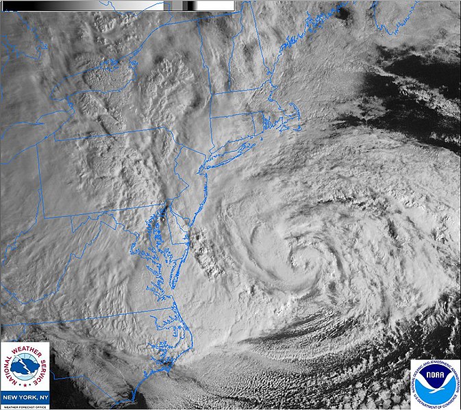
Nicknamed Superstorm Sandy by The Weather Channel, the category one hurricane slammed headlong into the New Jersey coast on the evening of October 29, 2012, bringing with it the equivalent storm surge of a category three hurricane. Tropical storm force winds covered an area 900 miles across.
New Jersey and the New York City area were hardest hit. The gambling mecca was nearly completely underwater by midafternoon. The tide reached 13.88 feet at The Battery, three feet higher than ever before, resulting in parts of Lower Manhattan being swamped. The result was flooded subway and rail tunnels and inundation further into neighborhoods in all five boroughs than anyone could remember.
A last-minute mandatory evacuation posted the morning of arrival by New York Mayor Michael Bloomberg for Zone A in the Big Apple helped get thousands out of harm’s way, although many refused to leave, perhaps remembering the overreaction to Hurricane Irene.
In addition to the high winds and coastal flooding, very heavy rains fell across eastern North Carolina, Virginia, Maryland, Delaware, southern New Jersey and southern Pennsylvania, with widespread 8-13 inch amounts being recorded.
Sandy caused significant problems well outside the main impact zone. Blizzard conditions occurred in western Maryland and West Virginia were up to three feet of snow fell in the cold air on the west side of the power system. Twenty-foot waves battered Chicago’s lakefront as high winds formed in the strength between the intense low (940 mb) and high pressure to the northwest.
When Sandy’s rampage was done, over 100 people were dead in New York and New Jersey, and damage totaled over $68 billion, making it the 2nd most expensive U.S. hurricane. But to add insult to injury, Sandy is not the worst-case storm for New York City. That’s hard to imagine, but the 1938 Long Island Express had top winds of 120 mph, making it a Category Three hurricane at landfall. If Sandy had been that strong, the impact would have been much more devastating to the Big Apple. And even that is not the rest of the story.
There’s still one more element to our story. Guess what the name was that those emergency planners gave to that practice storm in 1997. The fictional hurricane’s name was: wait for it……Sandy. You can’t make this stuff up.
And now you know the rest of the story. Brought to you by This Week in Weather History…
Follow my weather history tweets on Twitter. I am wxhistorian at Twitter.com
Category: ALL POSTS, Headlines, Met 101/Weather History
About the Author (Author Profile)
Bill Murray is the President of The Weather Factory. He is the site's official weather historian and a weekend forecaster. He also anchors the site's severe weather coverage. Bill Murray is the proud holder of National Weather Association Digital Seal #0001 @wxhistorianSubscribe
If you enjoyed this article, subscribe to receive more just like it.


