Midday Nowcast: More Clouds and Tropical Storm Lisa
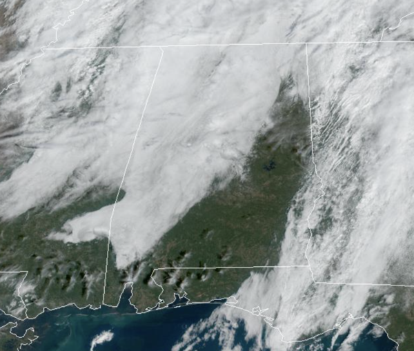
It was a foggy start to our Halloween, but the fog has mixed out and we are seeing a mix of sun and clouds today. There could still be some patchy drizzle in spots, but for the most part the weather is just fine for the last day of October. Temperatures this afternoon are in the low 70s. Most places will be dry for the trick or treaters this evening with temperatures falling through the 60s. Tonight, there will likely be some patch areas of fog developing once again as lows should be in the 50s.
HELLO NOVEMBER: For now the weather looks dry the rest of this week. We will continue to watch a weak disturbance that will swing through the state tomorrow night into Wednesday. There will be more clouds, but the air simply looks too dry for any rain. For the rest of the week, an upper ridge will build in, which will produce above average temperatures as afternoon highs surge into the upper 70s.
THE ALABAMA WEEKEND: A major threat for severe severe storms is possible well to the west Saturday over parts of Texas and Oklahoma, but the upper ridge will keep most of Alabama rain-free with highs close to 80° both days. A few showers could reach the northwest corner of the state Sunday afternoon/night ahead of a cold front.
FALL BACK: A heads up that the time changes this weekend as we fall back onto standard time. That will give us an extra hour of sleep Saturday night, but also mean sunset Sunday in Birmingham will be 4:50 PM CST.
NEXT WEEK: A few scattered showers are possible Monday, otherwise much of the week looks dry at this point as the major rain producers will stay north and west of here. Temperatures will remain mild with highs mostly in the 70s.
TROPICS: We now have Tropical Storm Lisa in the Caribbean. The center of Tropical Storm Lisa was located near latitude 15.5 North, longitude 77.3 West. Lisa is moving toward the west near 14 mph, and a westward to west-northwestward motion is expected over the next few days. On the forecast track, the center will pass south of Jamaica today, south of the Cayman Islands tomorrow, and approach Central America on Wednesday.
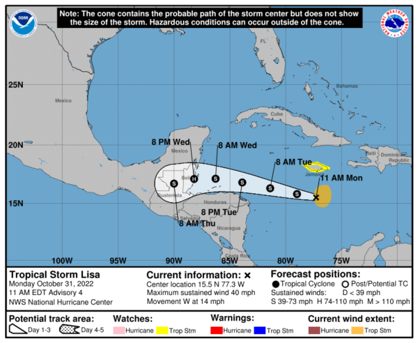
Maximum sustained winds remain near 40 mph with higher gusts. Slow strengthening is forecast during the next few days, and Lisa could become a hurricane over the northwestern Caribbean Sea. Tropical-storm-force winds extend outward up to 105 miles from the center. The minimum central pressure estimated from NOAA Hurricane Hunter aircraft dropsonde data is 1003 mb (29.62 inches). Hurricane season ends November 30th.
BEACH FORECAST CENTER: Get the latest weather and rip current forecasts for the beaches from Fort Morgan to Panama City on our Beach Forecast Center page. There, you can select the forecast of the region that you are interested in visiting.
WORLD TEMPERATURE EXTREMES: Over the last 24 hours, the highest observation outside the U.S. was 111.4F at Julia Creek, Australia. The lowest observation was -75.1F at Concordia, Antarctica.
CONTIGUOUS TEMPERATURE EXTREMES: Over the last 24 hours, the highest observation was 92F at Death Valley, CA. The lowest observation was 12F at Alamosa, CO.
Category: Alabama's Weather, ALL POSTS
About the Author (Author Profile)
Macon, Georgia Television Chief Meteorologist, Birmingham native, and long time Contributor on AlabamaWX. Stormchaser. I did not choose Weather, it chose Me. College Football Fanatic. @Ryan_StinnetSubscribe
If you enjoyed this article, subscribe to receive more just like it.


