Showers with Dropping Temperatures; Sunny & Very Cool on Sunday
THE CENTRAL ALABAMA WEEKEND
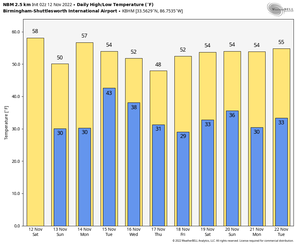
We’ll start off the morning today with showers moving eastward through Central Alabama, with the activity mainly out of the area by mid-afternoon. Skies will remain mostly cloudy. Daytime highs will actually occur around 12:01 am for locations north of I-59, but everyone will experience dropping temperatures throughout the day. Highs in the upper 40s to the mid 70s from northwest to southeast.
Sunday will start off chilly with early morning lows in the mid 20s to the mid 30s across the area with frost likely. Even with plenty of sunshine, afternoon highs will only make it into the mid 40s to the mid 50s.
Cooler temperatures are not going anywhere anytime soon.
THE WORK WEEK AHEAD
Much of the day on Monday will be mostly sunny, but clouds will begin to increase late ahead of our next disturbance. A few showers may be possible by the late evening and into the late-night hours. Highs in the lower 50s to the lower 60s.
That disturbance will bring a reinforcing shot of cooler air in behind the showers that we’ll see on Tuesday throughout the day. Expect a stiff breeze at times as well that will drop those wind chill factors a few degrees below actual temperatures. Highs in the lower 50s to the mid 60s.
Clouds will be slowly decreasing on Wednesday, but afternoon highs will be well below normal. Highs in the upper 40s to the upper 50s.
Clouds will be moving back on Thursday as another disturbance will be hitting the area. We can expect a good coverage of showers during the entire day and into the overnight hours. Highs in the mid 40s to the mid 50s.
And at the end of the forecast period on Friday… We’ll continue to have plenty of showers in the area through the morning and into the early afternoon before the activity starts to end from west to east. For now, the evening looks dry for those highs school playoff games. Highs in the upper 40s to the mid 50s.
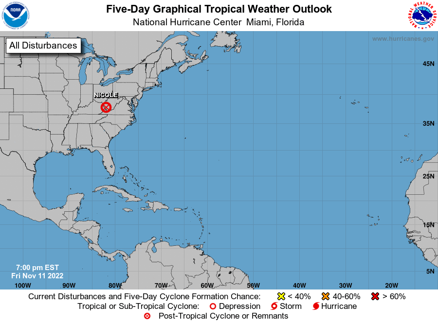
THE TROPICS (AS OF 8 PM FRIDAY)
The remnants of Nicole were continuing to move northeastward rather quickly and were in West Virginia at this time. While winds may be quite breezy at times over the northeast throughout the weekend, the risk of excessive rainfall and localized flooding will continue to diminish. The rest of the tropics are quiet at this time. Just a reminder… The end of the Atlantic Hurricane Season is November 30th.
ON THIS DAY IN WEATHER HISTORY – 1988
Thunderstorms developing ahead of a cold front produced severe weather in the Lower Mississippi Valley during the afternoon and early evening hours. Thunderstorms produced wind gusts to 80 mph at Bovina, MS. Morning thunderstorms drenched Atlanta, TX with more than four inches of rain.
Category: Alabama's Weather, ALL POSTS, Tropical, Weather Xtreme Videos
About the Author (Author Profile)
Scott Martin is an operational meteorologist, professional graphic artist, musician, husband, and father. Not only is Scott a member of the National Weather Association, but he is also the Central Alabama Chapter of the NWA president. Scott is also the co-founder of Racecast Weather, which provides forecasts for many racing series across the USA. He also supplies forecasts for the BassMaster Elite Series events including the BassMaster Classic.Subscribe
If you enjoyed this article, subscribe to receive more just like it.


