Sunday Morning Weather Briefing: Showers to Abound
Rain chances will be high through the week ahead, but we won’t be dealing with cold temperatures until the week of December 12th. Let’s dig into the damp details…
LOOKING BACK ON SATURDAY: The day started cloudy and wet with scattered showers dotting the landscape. A cold front dropping southeastward was the culprit, and that boundary is out of the state early on this Sunday morning. Highs on Saturday included 64F at Anniston, 71F at Birmingham, and 75F at Tuscaloosa.
GOING TO THE WEATHER MAPS: Much of the United States is under the influence of upper-level high pressure over the western Gulf of Mexico. That ridge will shift eastward into the Central Gulf. You would think this would mean fine weather, but not so fast my friend. Alabama is on the northern fringe of this ridge, which will make us vulnerable to occasional disturbances sliding across in the westerly flow aloft. Each one of those disturbances will bring a chance of rain with it. But the good news is, no severe weather in the week ahead.
STARTING UP SUNDAY: Dense fog developed rapidly after sunset in areas along and south of I-59. Visibilites were near zero overnight at some South Central Alabama locations. Drier air worked into areas northwest of I-59, which held down the development of fog. It is much cooler behind the cold front today, with 50s for expected highs along and north of I-20. A couple of places in North Alabama will struggle to get out of the 40s today, while areas to the south will still experience the mid and upper 60s. We can’t rule out a couple of sprinkles today as a disturbance swipes by to the north of us. Lows tonight will be in the 40s with thick clouds and a southeasterly wind kicking in after midnight. Showers will begin to return overnight as well.
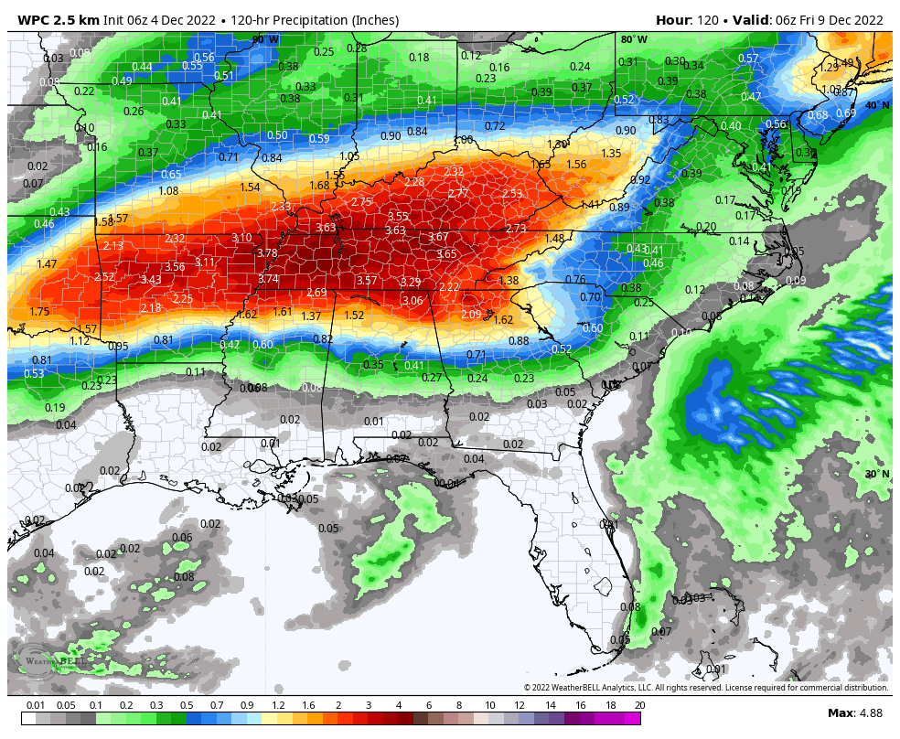
MONDAY/TUESDAY: Another disturbance will lift the old front northward, bringing the attendant lift along with it, and the result for North and Central Alabama will be widespread light to occasionally moderate rain. It is interesting to note that the Weather Prediction Center has outlooked North and Central Alabama for an excessive rainfall risk on Monday and Monday night. Rainfall amounts then could reach 2-4 inches across the Tennessee Valley of North Alabama and southern Tennessee. A few storms could be mixed in Monday afternoon and night, but severe weather will not be a problem. High temperatures will exhibit quite a range across the state Monday, with 50s in the northeastern corner, 60s in the I-22/US-280 Corridor, and lower 70s to the southwest. On Tuesday, the ridge lifts northward and rain will lift back with it into Tennessee. I am worried about the rainfall amounts that will total up over the Volunteer State. Rainfall amounts could reach 7 inches in parts of middle Tennessee. Highs on Tuesday will be in the upper 60s North, lower 70s Central and upper 70s South.
MIDWEEK AND BEYOND: With the ridge in place over Alabama and the Deep South, record warmth will be the interesting thing to watch. Highs on Wednesday and Thursday will be in the 70s. Record highs at Birmingham for December 6th and 7th are 78 and 80 degrees respectively. While those records may be safe, we still will be warm. Skies will be mostly cloudy to partly sunny at times. We can’t rule out a shower or two, but the best rain chances will be up over the Tennessee Valley. Lows will be around 60 degrees.
END OF THE WEEK AND WEEKEND: Another frontal system will approach Alabama on Thursday. This will bring a band of showers through the state Thursday night, perhaps extending into Friday morning. Temperatures will be slightly cooler on Saturday and Sunday. Rain chances will return ahead of another cold front on Saturday night. Weekend highs will be in the 60s. Lows will drop back into the upper 40s and lower 50s.
WEEK TWO: It looks like we will have a respite from the rain on Monday and Tuesday of the following week, but high rain chances return with a couple of active weather systems on Wednesday and Friday. Temperatures will be trending downward with highs falling back into the 50s and lows in the 30s.
BEACHCAST: There will be a few showers along the beautiful beaches of Alabama and Northwest Florida through Monday night, but a surface high is expected to develop across the region by Tuesday, giving them dry weather until a frontal system brings more wet weather late in the weekend. Highs will be in the 70s all week, threatening to touch 80F around midweek. Lows will be in the 60s. Just about perfect for December. Water temperatures are right around 60F. The rip current is expected to be fairly low for the next several days.
Click here to see the Beach Forecast Center page.
NATIONALLY: A storm system off the coast of Oregon and California is bringing mountain snows and lower-elevation rain to the West. Rain showers and mountain snow will continue from Washington to much of California on Sunday, with snow extending into the Great Basin and northern Rockies. Some rain showers are likely in Arizona and New Mexico. Winter storm warnings are in effect for the Sierra, where they could measure the snow in feet. Winter weather advisories are in effect for wide areas from Northern California to the Rocky Mountains of Montana and Wyoming.
DANCING WITH THE STATS: Ten tornadoes have been documented across Central Alabama from last Tuesday and Wednesday’s severe weather event by investigators from the National Weather Service Birmingham. 6 were rated EF0, 2 ranked as EF1, and two were EF2. The Flatwood-Willow Springs EF2 had winds of 120 mph as it moved across parts of Elmore and Montgomery Counties. This is the storm that killed 2 people when trees fell on a mobile home.
WEATHERBRAINS: This week, the panel will commemorate the December Kentucky tornado outbreak, which is the deadliest in the Bluegrass State’s history. Check out the show at www.WeatherBrains.com. You can also subscribe on iTunes. You can watch the show live at live.bigbrainsmedia.com or on James’ YouTube Channel You will be able to see the show on the James Spann 24×7 weather channel on cable or directly over the air on the dot 2 feed.
ON THIS DATE IN 1952: A beautiful chilly morning would turn deadly as high pressure caused the atmosphere over London to stagnate. By the 5th, a thick “fog” covered the city. Residents started to complain of a burning sensation in their throats. Soon, everything was covered with a dirty layer of soot. Visibility dropped to zero. Hundreds of people were admitted to hospitals because of respiratory distress. Over 4,000 people died. Other major toxic fogs affected the city in December 1873, January 1880 and in 1892, but the 1952 is London’s worst ever smog event. Follow my weather history tweets on Twitter. I am @wxhistorian at Twitter.com.
Category: Alabama's Weather, ALL POSTS, Weather Xtreme Videos
About the Author (Author Profile)
Bill Murray is the President of The Weather Factory. He is the site's official weather historian and a weekend forecaster. He also anchors the site's severe weather coverage. Bill Murray is the proud holder of National Weather Association Digital Seal #0001 @wxhistorianSubscribe
If you enjoyed this article, subscribe to receive more just like it.


