Midday Nowcast: Clouds Today; Rain and Storms Tomorrow
It remains generally cloudy today with temperatures in the 60s and 70s across the state. A few light showers are possible the rest of today, but most locations will remain dry.
WET/STORMY WEDNESDAY: A dynamic weather system will bring the dual threat of heavy rain and severe thunderstorms to Alabama tomorrow. On the cold side of this system, winter storm and blizzard warnings are in effect for the Plains and Midwest today and the next few days. We are on the warm side, and the SPC has an “enhanced risk” (level 3/5) of severe thunderstorms for Southwest Alabama…areas west of a line from Demopolis to Uniontown to Luvurne to Opp. A “slight risk” (level 2/5) extends as far north as Tuscaloosa, Clanton, and Tuskegee, and a “marginal risk” is in place to Birmingham.
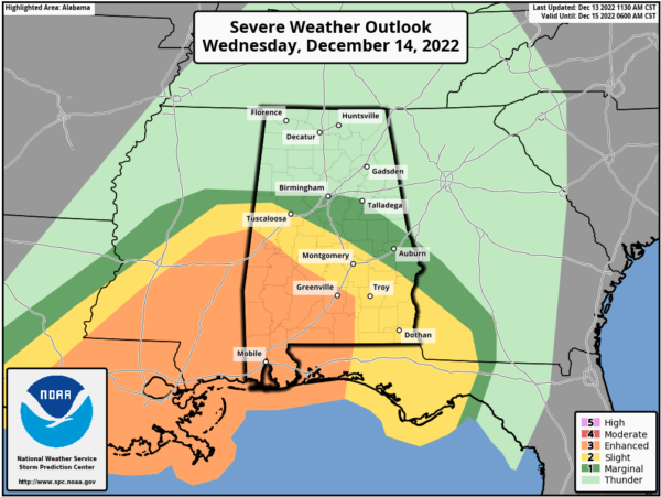
Thunderstorms over the southern portions of the state tomorrow will likely produce damaging wind gusts, and there is some tornado potential as veering/increasing flow with height anticipated across the area will be favorable for supporting evolution of rotating updrafts/supercells. A few strong tornadoes are possible as well, especially over Southwest Alabama in the “enhanced risk”. As of now, the limited surface based instability means that storms over the northern half of Alabama will likely remain below severe limits, but heavy rain is possible statewide, with amounts of 2-3 inches very possible. Some flooding issues could develop. We note, Flood Watches have been issued for the Tennessee Valley as well as much of Mississippi. We could see these extended into Central Alabama.
Most of tomorrow will be wet and stormy day for the state, but the core threat for severe storms over southern portions of the state will come from about noon tomorrow until midnight.
The associated cold front will swing through the state late tomorrow night, bringing an end to the rain and storm threat, and delivering a colder, drier air mass for Thursday with highs in the upper 50s for most locations.
FRIDAY AND THE WEEKEND: Friday and Saturday will be dry and much colder. The high Friday will be 50s, and only in the mid and upper 40s Saturday. Temperatures go below freezing Saturday morning Most of the state will stay dry Sunday, but a feature will work along the Gulf Coast this weekend will bring clouds and some rain along the Gulf Coast. Highs Sunday will be in the 40s over North Alabama, with 50s for the southern counties of the state.
NEXT WEEK AND BEYOND: Some light rain is possible Monday or Tuesday, otherwise the week looks dry with highs in the 40s and 50s, and lows mostly in the 20s and 30s. We continue to see strong signals in global models of very cold air moving into the Deep South around Christmas. But December 25 is still 12 days away and there is no skill in a specific forecast for now.
BEACH FORECAST CENTER: Get the latest weather and rip current forecasts for the beaches from Fort Morgan to Panama City on our Beach Forecast Center page. There, you can select the forecast of the region that you are interested in visiting.
WORLD TEMPERATURE EXTREMES: Over the last 24 hours, the highest observation outside the U.S. was 107.8F at Richmond Airport, Australia. The lowest observation was -76.0F at Ojmjakon, Russia.
CONTIGUOUS TEMPERATURE EXTREMES: Over the last 24 hours, the highest observation was 88F at Rio Grande Village, TX. The lowest observation was -13F at Bryce Canyon, UT.
Category: Alabama's Weather, ALL POSTS, Severe Weather
About the Author (Author Profile)
Macon, Georgia Television Chief Meteorologist, Birmingham native, and long time Contributor on AlabamaWX. Stormchaser. I did not choose Weather, it chose Me. College Football Fanatic. @Ryan_StinnetSubscribe
If you enjoyed this article, subscribe to receive more just like it.


