Dry Through The Weekend; Arctic Blast A Week Away
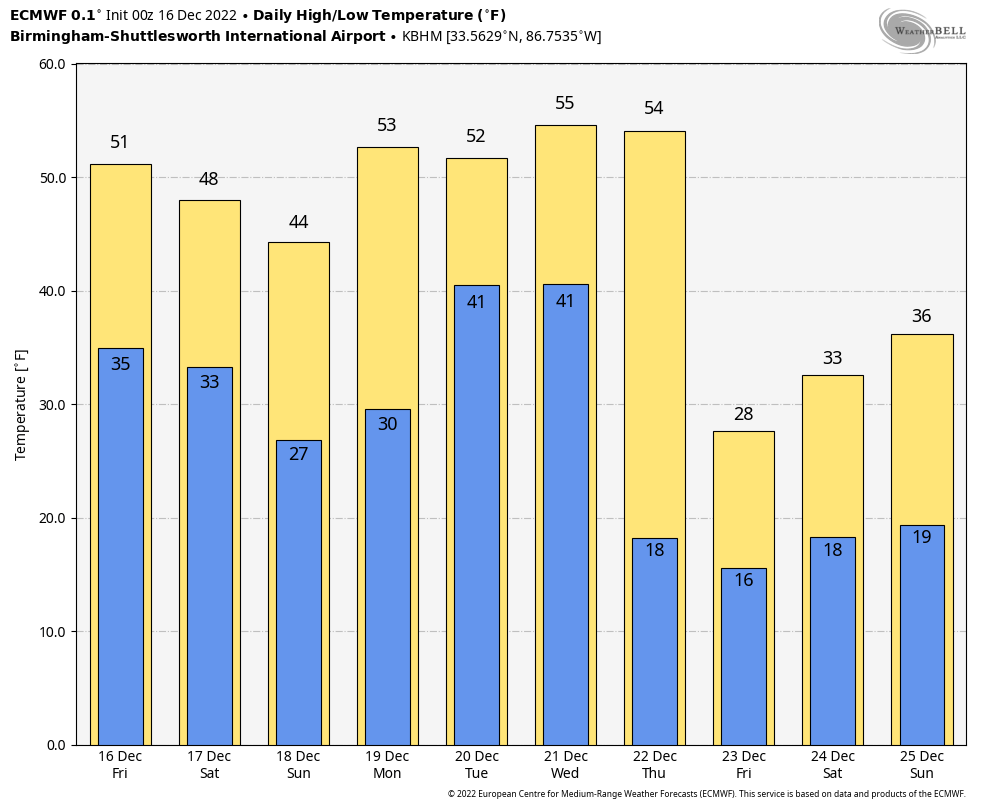
DRY WEEKEND AHEAD: Alabama’s weather will remain generally dry through the weekend with mostly sunny days, fair nights, and seasonal temperatures. Look for afternoon temperatures mostly in the 50s today and tomorrow, followed by a high in the 45-55 degree range Sunday. Morning lows will be somewhere between 25 and 35 degrees for most communities.
The exception is near the Gulf Coast; a disturbance in the southern branch of the jet stream could bring a bit of light rain tomorrow afternoon/evening, but even there is the air is dry and most places won’t see anything more than few sprinkles.
NEXT WEEK: Another wave has potential to bring some light rain to the state Monday night and Tuesday, mainly over the southern counties. Wednesday looks dry… highs will be in the upper 40s and low 50s during the first half of the week.
An Arctic front will bring potential for a little light rain to North Alabama Thursday afternoon, and as cold air rushes into the state, a few snow flurries are possible Thursday night. But, for now, this doesn’t look a setup for any accumulating snow. The big story is the coldest air so far this season that will rush into the state Friday.
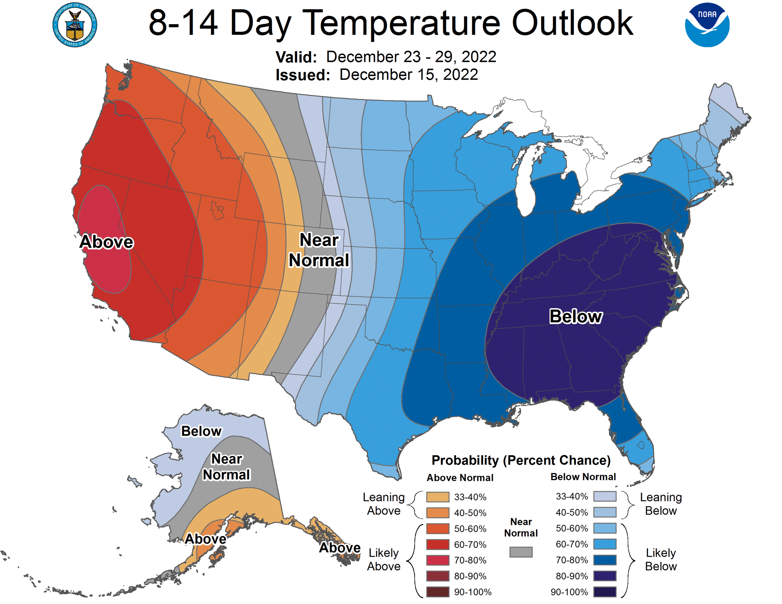
ARCTIC BLAST: Here are few notes on the Christmas cold wave…
*Temperatures will likely remain below freezing across North Alabama all day Friday and Saturday (December 23-24). Temperatures should rise into the mid to upper 30s by Christmas (Sunday December 24).
*Early morning lows will be mostly in the teens Friday and Saturday morning (December 23-24), but colder spots over North Alabama could dip into the single digits.
*The wind chill index Friday (December 23) will be below zero at times over North Alabama thanks to a brisk north wind.
*The American global model (the GFS) occasionally has hinted at a chance of snow on Christmas Day across parts of Alabama, but they idea has little support for now from the reliable European model (the ECMWF), or ensembles. For now we are forecasting a a cold, dry Christmas, but understand that could change since December 25 is 9 days away. You will see the deterministic GFS snow maps plastered all over social media from those needing shares and followers, but don’t be suckered into it.
See the daily Weather Briefing video for maps, graphics, and more details.
ON THIS DATE IN 2000: An F4 tornado tore through the southern part of Tuscaloosa, killing eleven people and injuring over 100. Nine of the fatalities occurred in mobile homes, one in a vehicle, and one in a commercial building converted to residential use. Six of those killed were females and five were males. Ages ranged from 16 months to 83 years old. The tornado was on the ground for a total of 18 miles, all within Tuscaloosa county. The tornado path was estimated to be 750 yards wide at it’s maximum intensity.
There was an excellent warning for the tornado; a warning was issued at 12:40 p.m. on that deadly Saturday, 14 minutes before the twister first touched down in a rural area southwest of Tuscaloosa near the Black Warrior River. The tornado crossed Alabama 69 near Shelton State Community College and Hillcrest High School; destroying a shopping center and many homes. The Bear Creek Trailer Park was hit, where many of the deaths occurred. The tornado moved to the east/northeast, south of Skyland Boulevard, and finally crossed I-59/20 near the Cottondale exit.
Later in the day, the same parent storm dropped an F3 tornado which stuck the Coats Bend region of Etowah County, near Gadsden, damaging 250 homes and injuring 14 people. Like the Tuscaloosa tornado, excellent warnings were issued by the National Weather Service long before the damage occurred. Just another reminder we can have some very violent weather this time of the year.
BEACH FORECAST: Click here to see the AlabamaWx Beach Forecast Center page.
Look for the next Weather Briefing here by 3:00 this afternoon… enjoy the day!
Category: Alabama's Weather, ALL POSTS, Weather Xtreme Videos
About the Author (Author Profile)
James Spann is one of the most recognized and trusted television meteorologists in the industry. He holds the AMS CCM designation and television seals from the AMS and NWA. He is a past winner of the Broadcast Meteorologist of the Year from both professional organizations.Subscribe
If you enjoyed this article, subscribe to receive more just like it.


