Rain At Times Through Tomorrow; Frigid, Arctic Air Arrives Friday
RADAR CHECK: Light rain is moving into Alabama this afternoon; some sleet was mixed with the rain as it started to fall over parts of West Alabama earlier this afternoon. Expect periods of rain through tomorrow; the most widespread rain will be over the southern half of the state… amounts should be generally under 1/2 inch. Otherwise, it will be cloudy and cold through tomorrow.
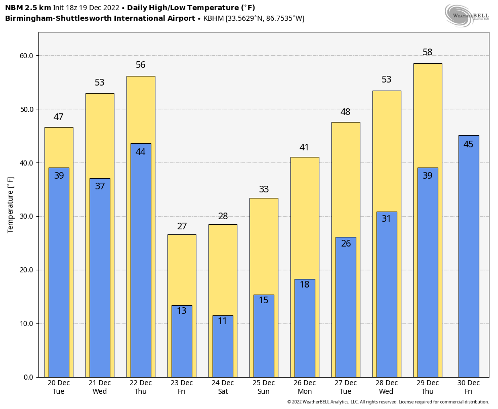
Wednesday will be a dry day with a mix of sun and clouds; temperatures reach the mid 50s, not far from average values for late December. Clouds return on Thursday, and some rain will develop during the day.
CHRISTMAS COLD WAVE: A bitterly cold, Arctic airmass will invade the Deep South Thursday night, and will persist through the Christmas weekend. Here are some important points…
*There is a chance rain could briefly change to snow over North Alabama before ending late Thursday night and early Friday morning. This is a “cold air chasing the moisture” setup, which rarely produces meaningful snow accumulation here. So, yes, we will probably see a few snow flakes over the northern half of the state, but with no accumulation. Major travel impact is not expected, but if there is any standing water left from the rain Friday morning there could be a few icy spots. So, use caution if you drive Friday morning, but strong north winds will help dry the roads very quickly.
*The focus needs to be on the cold air. The wind chill index will drop into the -5 to -15 degree range Friday morning over the northern half of Alabama, with single digit wind chills down to the coast. In terms of air temperature, the coldest morning will come early Saturday with a low in the 6-12 degree range. Hard Freeze Warnings and Wind Chill Warnings will likely be needed.
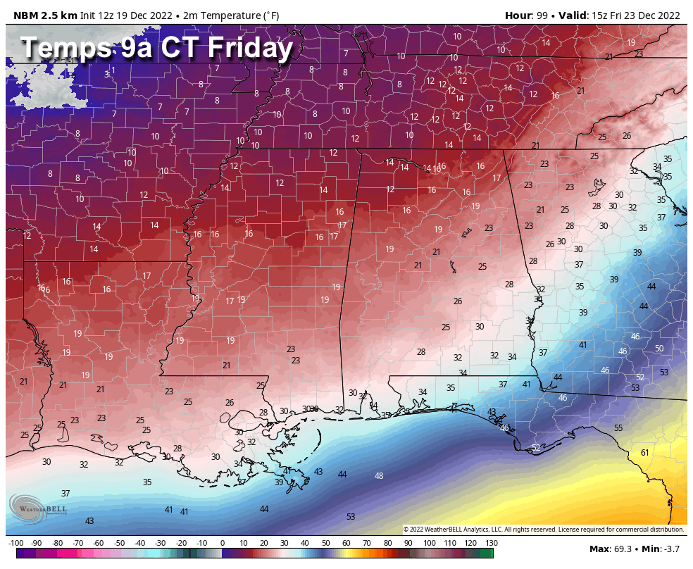
*Much of North/Central Alabama will go around 75 consecutive hours with sub-freezing temperatures… from early Friday morning until late morning, Monday December 26.
*The Arctic airmass Saturday and Sunday will be very dry; the sky will be mostly sunny over the weekend.
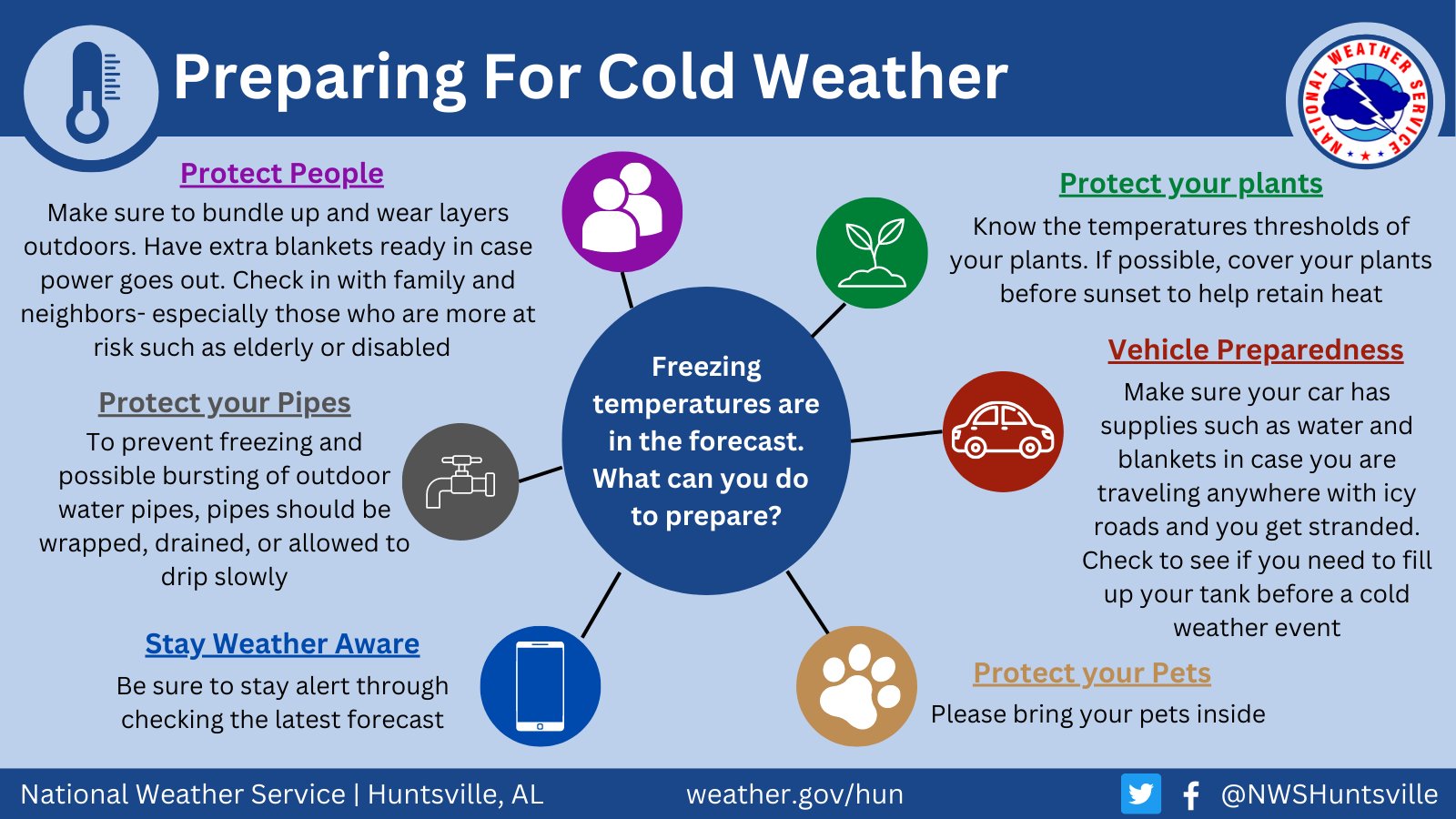
*Cold waves like this are a serious threat to people with no adequate heating source. Check on the elderly. Be very, very careful with space heaters. Plan on bringing your pets indoors. Exposed pipes will need to be wrapped with insulation. Learn how to shut off water valves for potential pipe bursts.
*From a historical perspective, the last time temperatures reached the single digits in Birmingham during the month of December was in 1989… we dropped to 1 degree on December 23 during the peak of the cold wave. We have achieved single lows during the month of December in eight years since 1900; in 1901, 1917, 1925, 1926, 1962, 1981, 1983, and 1989. We might not reach the single digits this year, but it will be a very close call.
*This will be the coldest air in Alabama since January 2, 2018; Birmingham dropped to 11 degrees during that cold wave.
NEXT WEEK: The week looks generally dry with a warming trend… See the daily Weather Briefing video for maps, graphics, and more details.
ON THIS DATE IN 2009: Snowfall totals from 1 to 2 feet were commonplace in what will go down as one of the biggest snowstorms in history on the East Coast and the first of four snowstorms for the Mid-Atlantic during the winter of 2009-10. The 15 inches of snow measured at Reagan International Airport on Dec. 19th was the third-highest daily snowfall on any calendar day at Washington, DC, since snowfall records began in 1884. The total storm snowfall of 16.4 inches on Dec 18-19 2009 marks the 6th highest two-day snowfall record for Washington, DC putting it just below the second President’s Day storm in 2003 and ahead of the Jan 1996 storm.
BEACH FORECAST: Click here to see the AlabamaWx Beach Forecast Center page.
Look for the next Weather Briefing video here by 6:00 a.m tomorrow…
Category: Alabama's Weather, ALL POSTS, Weather Xtreme Videos
About the Author (Author Profile)
James Spann is one of the most recognized and trusted television meteorologists in the industry. He holds the AMS CCM designation and television seals from the AMS and NWA. He is a past winner of the Broadcast Meteorologist of the Year from both professional organizations.Subscribe
If you enjoyed this article, subscribe to receive more just like it.


