Windy Day Ahead With Strong To Severe Storms Possible
RADAR CHECK: Showers and thunderstorms are forming across Mississippi just before daybreak ahead of a cold front. Storms will enter West Alabama shortly, then progressing through the rest of the state during the day.
SPC has defined an “enhanced risk” (level 3/5) of severe thunderstorms for parts of Central and East Alabama, including places like Birmingham, Gadsden, Anniston, Montgomery, Clanton, Alexander City, Opelika, and Troy. A “slight risk” (level 2/5) covers much of the rest of the state.
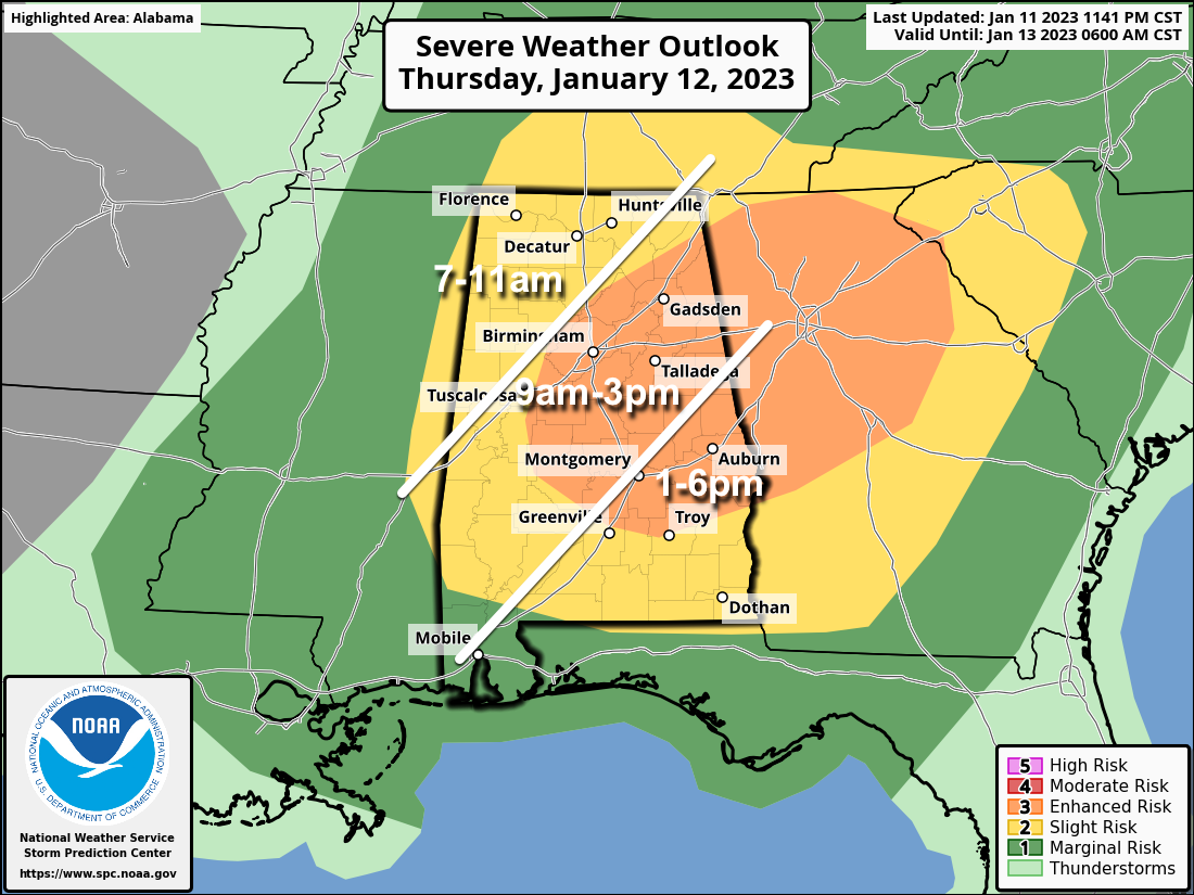
THREATS: The primary threat will come from strong, potentially damaging straight line winds. Heavier thunderstorms could also produce hail, and a couple of brief, isolated tornadoes can’t be ruled out.
GRADIENT WIND: Today will be a windy day, and a wind advisory has been issued for all 67 Alabama counties. Gradient winds (not related to thunderstorms) could gust to 40 mph in spots.
RAIN: Rain amounts will be generally around 1/2 inch, with isolated amounts to one inch. Flooding is not expected.
Be sure you can hear severe weather warnings today if they are needed (never rely on a siren!!!), and be ready to take action if you are in a polygon.
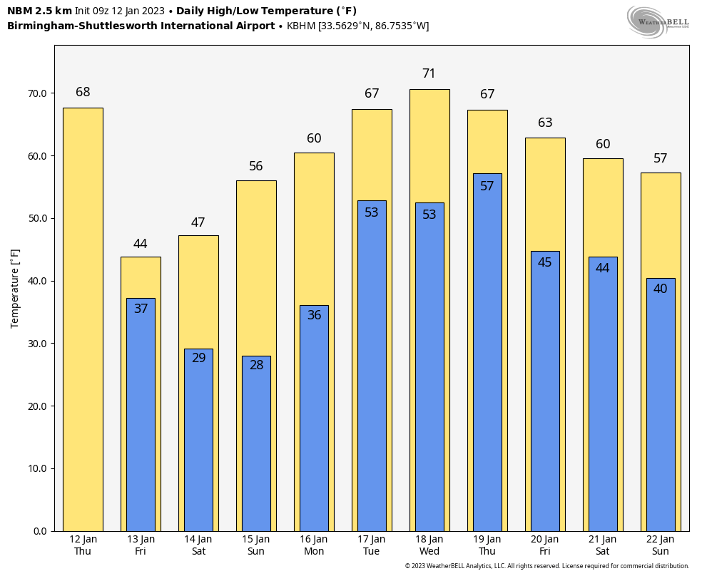
SNOW FLAKES? Much colder air will roll into the state tonight, and as an upper trough passes overhead we could see a few snow flurries tomorrow over the northern half of the state. If we do see any snow flakes, there won’t be any impact or accumulation. Otherwise, tomorrow will feature a mix of sun and clouds with a high in the 40s over North Alabama, with 50s to the south.
THE ALABAMA WEEKEND: Look for sunny cool days and clear cold nights. Morning lows will be in the 20s over the northern half of the state… highs will be in the 46-54 degree range Saturday, followed by 50s and 60s Saturday.
NEXT WEEK: The weather will be active; the first round of showers and storms will come Monday night into Tuesday morning. More rain is likely Wednesday night into Thursday; a few strong storms could be involved with that system. Highs will be in the 60s through most of the week; some places could reach the low 70s by mid-week. See the daily Weather Briefing video for maps, graphics, and more details.
ON THIS DATE IN 1888: Children’s or Schoolhouse Blizzard occurred on this day. The blizzard killed 235 people, many of whom were children on their way home from school, across the Northern Plains.
ON THIS DATE IN 1985: A record snowstorm struck portions of western and south-central Texas. All snowfall records dating back to 1885 were easily broken. Austin measured 3.6 inches, and Del Rio received 8.6 inches. San Antonio saw a record-setting 13.5 inches from this event.
BEACH FORECAST: Click here to see the AlabamaWx Beach Forecast Center page.
Look for the next Weather Briefing video here by 3:00 this afternoon… enjoy the day!
Category: Alabama's Weather, ALL POSTS, Weather Xtreme Videos
About the Author (Author Profile)
James Spann is one of the most recognized and trusted television meteorologists in the industry. He holds the AMS CCM designation and television seals from the AMS and NWA. He is a past winner of the Broadcast Meteorologist of the Year from both professional organizations.Subscribe
If you enjoyed this article, subscribe to receive more just like it.


