Dry Through Saturday; Chilly Nights
DRY THROUGH SATURDAY: Nothing on radar this afternoon; the sky is partly sunny over the northern half of the state, with sunshine in full supply over the southern counties. Temperatures are in the 40s across North Alabama, about ten degrees below average for January 26. Tonight will be clear and cold with sub-freezing temperatures in most places. Colder spots will dip into the low to mid 20s by daybreak tomorrow.
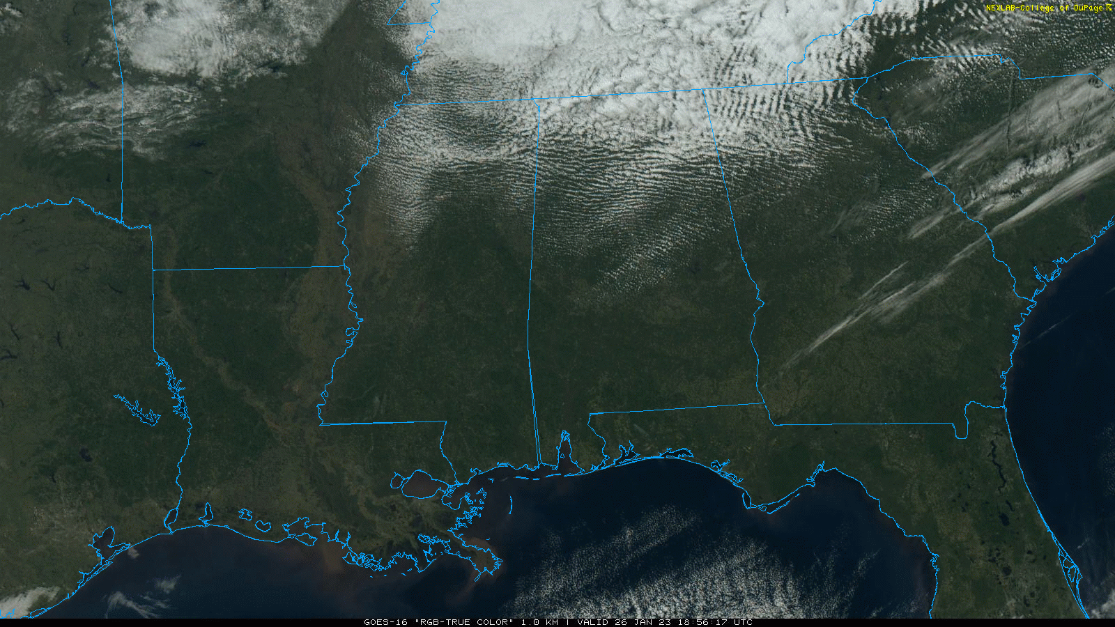
Expect a sunny sky tomorrow with highs in the 50s and 60s.
THE ALABAMA WEEKEND: The weather stays dry Saturday with a partly to mostly sunny sky. The high across North Alabama will be somewhere between 55 and 60 degree, with low to mid 60s for the southern counties. Clouds increase Saturday night, and wet weather returns to the state Sunday with periods of rain. Some thunder is possible, but there is no risk of severe storms with highs in the 50s.
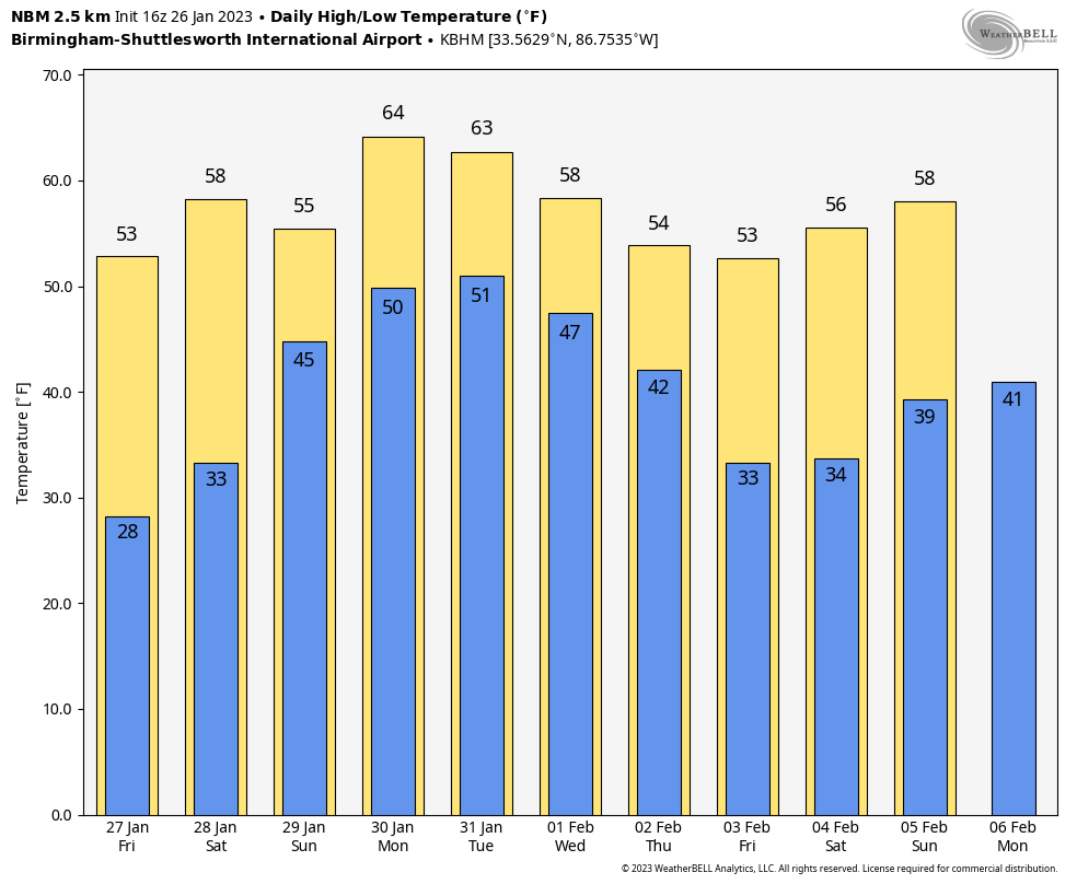
NEXT WEEK: We catch a break in the rain Monday, but a surface front will settle into the state Tuesday and become stationary, brining unsettled, wet weather through mid-week. We expect occasional rain Tuesday through Thursday… rain amounts of 1-3 inches are likely statewide. A few thunderstorms are possible along the way, but at this point we aren’t expecting anything severe. Colder, drier air arrives Friday. Highs through the week will be seasonal… mostly in the 50s and 60s. See the daily Weather Briefing video for maps, graphics, and more details.
HOLE PUNCH CLOUDS: Fallstreak holes (also known as “hole punch clouds”) were spotted across South Alabama this morning…
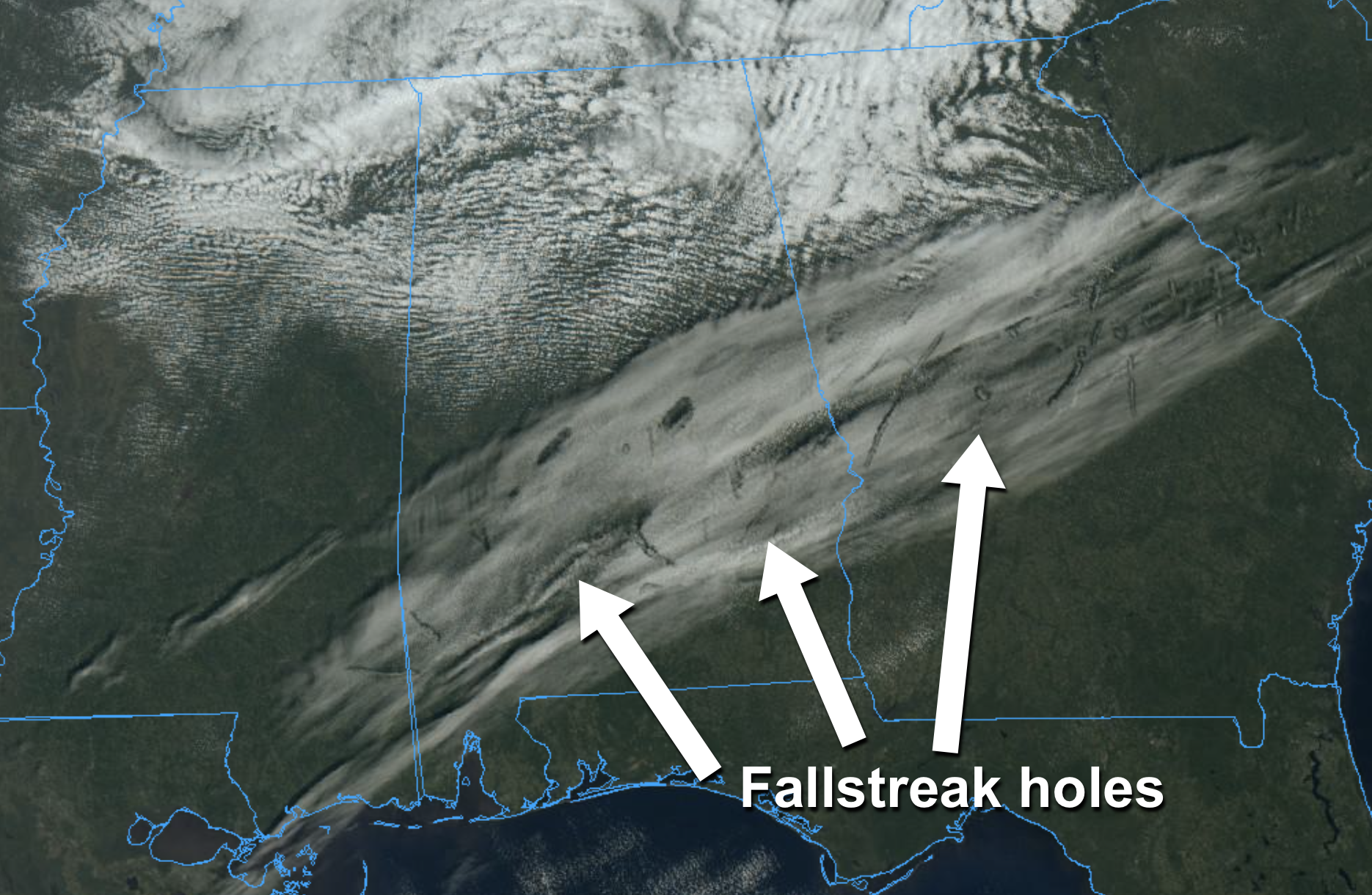
These are generally caused by a passing aircraft. When an aircraft passes through these types of clouds, the air around its wings and body expands and cools, a process known as adiabatic cooling. This can trigger the droplets to turn into tiny ice crystals. As they quickly grow and absorb nearby water droplets, they become heavier and begin to fall, leaving a hole behind, which will start to expand outward as surrounding droplets start to freeze as well.
ON THIS DATE IN 1772: Possibly the greatest snowfall ever recorded in the Washington DC area started on this day. When the storm began, Thomas Jefferson was returning home from his honeymoon with his new bride, Martha Wayles Skelton. The newlyweds made it to within eight miles of Monticello before having to abandon their carriage in the deep snow. Both finished the ride on horseback in the blinding snow. The newlyweds arrived home late on the night of January 26th. In Jefferson’s “Garden Book,” he wrote, “the deepest snow we have ever seen. In Albermarle, it was about 3 feet deep.”
ON THIS DATE IN 1940: Skaters were actually able to skate on the frozen surface of the Black Warrior River west of Birmingham, where ice was six inches thick near the banks after a week of some of the coldest weather the Magic City has ever seen. The official low at Birmingham on January 26, 1940 was 1.
BEACH FORECAST: Click here to see the AlabamaWx Beach Forecast Center page.
Look for the next Weather Briefing video here by 6:00 a.m. tomorrow…
Category: Alabama's Weather, ALL POSTS, Weather Xtreme Videos
About the Author (Author Profile)
James Spann is one of the most recognized and trusted television meteorologists in the industry. He holds the AMS CCM designation and television seals from the AMS and NWA. He is a past winner of the Broadcast Meteorologist of the Year from both professional organizations.Subscribe
If you enjoyed this article, subscribe to receive more just like it.


