Midday Nowcast: 30s North, 70s South
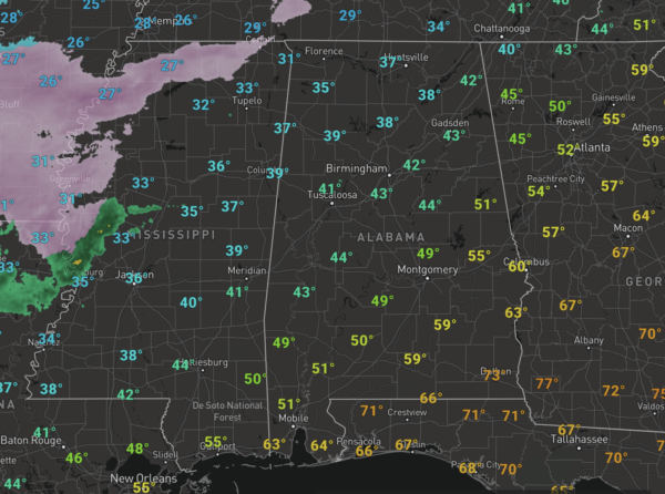
It remains cloudy with quite the temperature range across the state as a cold front bisects the state. Temperatures in the Tennessee Valley are in the 30s, while we have 40s in Central Alabama, and 70s across South Alabama. A few showers remain possible at about anytime, but many locations stay dry today. We are watching a mess to our west as Winter Storm and Ice Storm Warnings are in effect from the Mexican border to Central Tennessee. Thankfully all that remains to the west of the state.
WET TOMORROW: The main system lifts through the area tomorrow and will bring a widespread, soaking rain to the state. Rain amounts of 1-2 inches are likely across North/Central Alabama. The air will be stable with temperatures in the 50s so no severe storms for most of the state, however, the SPC maintains a “marginal risk” (level 1/5) of severe thunderstorms for locations across South Alabama and the Gulf Coast… a few storms there could produce gusty winds, and there is a low end threat of a brief tornado or two as the air will be more unstable due to temperatures in the 70s.
FRIDAY AND THE WEEKEND: Dry air returns Friday with a clearing sky, and Saturday will feature sunshine in full supply. A disturbance will bring some clouds Sunday along with the chance of some light rain, but noting too heavy or widespread at this time. Temperatures over the weekend will be seasonable with highs in the 50s and lows in the 30s and 40s.
NEXT WEEK: Monday and Tuesday look rain-free, but rain and maybe some storms will return on Wednesday with a cold front. Drier air follows by Thursday and Friday. Seasonable temperatures next week with highs in the 50s and 60s, and lows mainly in the 40s.
BEACH FORECAST CENTER: Get the latest weather and rip current forecasts for the beaches from Fort Morgan to Panama City on our Beach Forecast Center page. There, you can select the forecast of the region that you are interested in visiting.
WORLD TEMPERATURE EXTREMES: Over the last 24 hours, the highest observation outside the U.S. was 108.3F at Augrabies Falls, South Africa.The lowest observation was -57.1F at Amga, Russia.
CONTIGUOUS TEMPERATURE EXTREMES: Over the last 24 hours, the highest observation was 90F at Immokalee, FL. The lowest observation was -33F at Estcourt Station, ME.
Category: Alabama's Weather, ALL POSTS
About the Author (Author Profile)
Macon, Georgia Television Chief Meteorologist, Birmingham native, and long time Contributor on AlabamaWX. Stormchaser. I did not choose Weather, it chose Me. College Football Fanatic. @Ryan_StinnetSubscribe
If you enjoyed this article, subscribe to receive more just like it.


